A strong winter storm will bring the potential for mixed precipitation to the Cincinnati area Saturday, transitioning to snow Saturday night.

This Hazardous Weather Outlook is for Southeast Indiana, Central Ohio, South Central Ohio and Southwest Ohio.

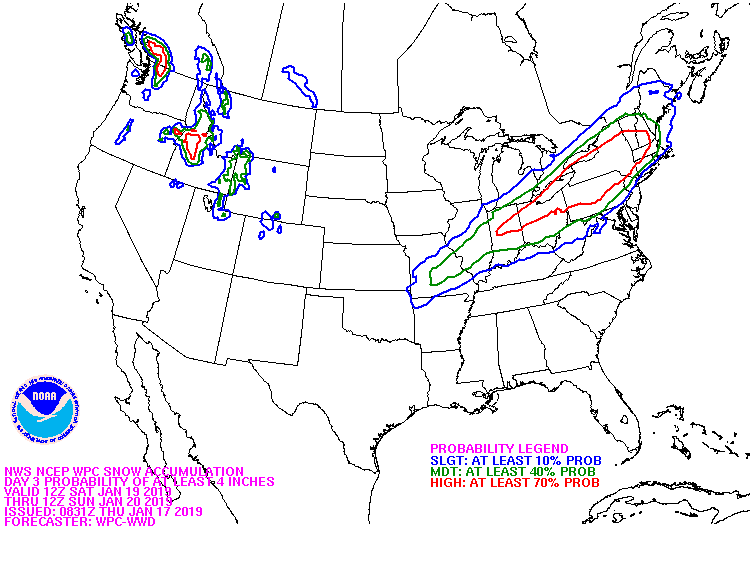
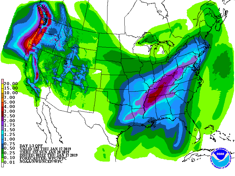
A strong winter storm will bring the potential for mixed precipitation to the area Saturday, transitioning to snow Saturday night. Current forecasts of this mixed precipitation favors the potential for significant snow, depending on the track of low pressure moving through the Tennessee and Ohio River Valleys. In addition, some ice accumulations will be possible. There are flooding concerns as well, especially south of the Ohio River.

An Arctic air mass will bring gusty winds Saturday night into Sunday
with bitterly cold subzero wind chills possible Sunday night into
Monday. Some blowing and drifting of snow will be possible as well
Saturday night into Sunday.

Earth’s magnetic field is acting up and geologists don’t know why

Erratic motion of north magnetic pole forces experts to update model that aids global navigation.

Something strange is going on at the top of the world. Earth’s north magnetic pole has been skittering away from Canada and towards Siberia, driven by liquid iron sloshing within the planet’s core. The magnetic pole is moving so quickly that it has forced the world’s geomagnetism experts into a rare move. Read more here>>>

Soil Moisture Condition Monitoring Weekly Report: Severely Wet

Station Number: OH-HM-24
Station Name: Cheviot 3.4 W
Report Date: 1/6/2019
Submitted: 1/06/2019 7:53 AM
Scale Bar: Severely Wet
Description:

1.85 inches of rain over the past week. Soil is wet. Ground is completely saturated with water. Standing water is severe and abundant. Water bodies are very elevated.

Categories:

General Awareness
Agriculture
Plants & Wildlife

This report is specifically for the Arbor Doctor’s location 3.4 miles west of Cheviot, OH, in the western suburbs of Cincinnati in southwest Ohio. This location is also an official cooperative observation site for the National Weather Service listed as Cheviot 3W.

What is the Condition Monitoring Report? See these links for more information:

Explanation of scale bar>>>

Search condition monitoring reports for the entire US>>>