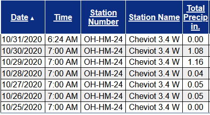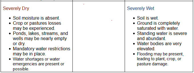
Soil Moisture Condition Monitoring Weekly Report: Moderately Wet

United States Drought Monitor

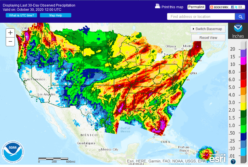
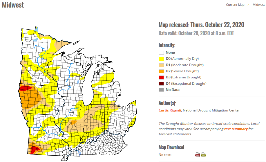
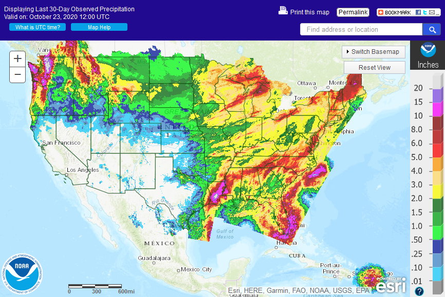
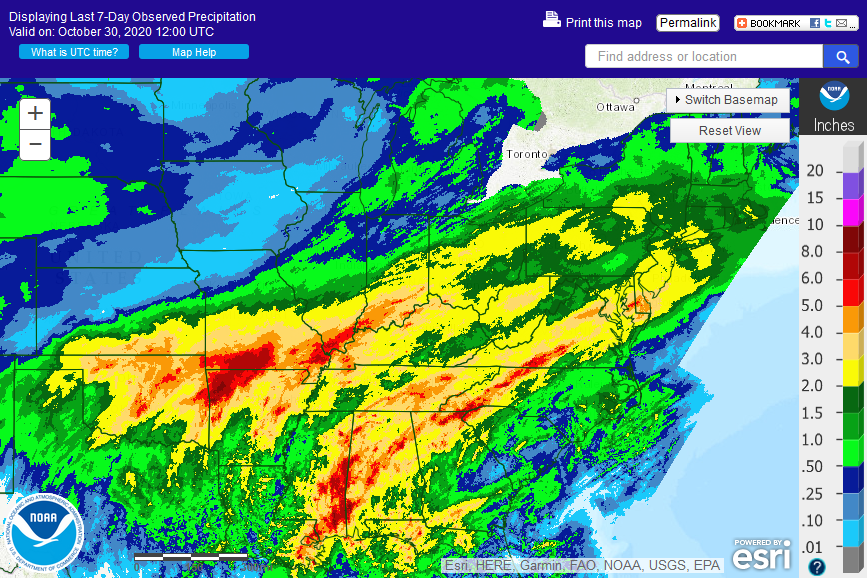
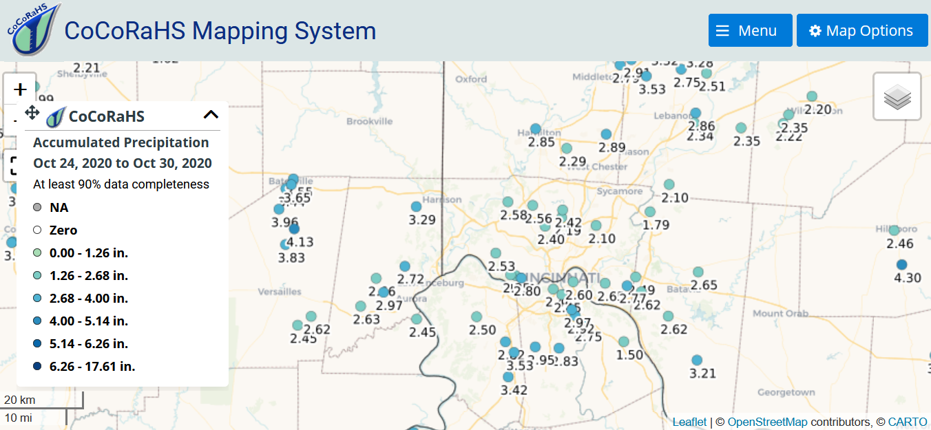
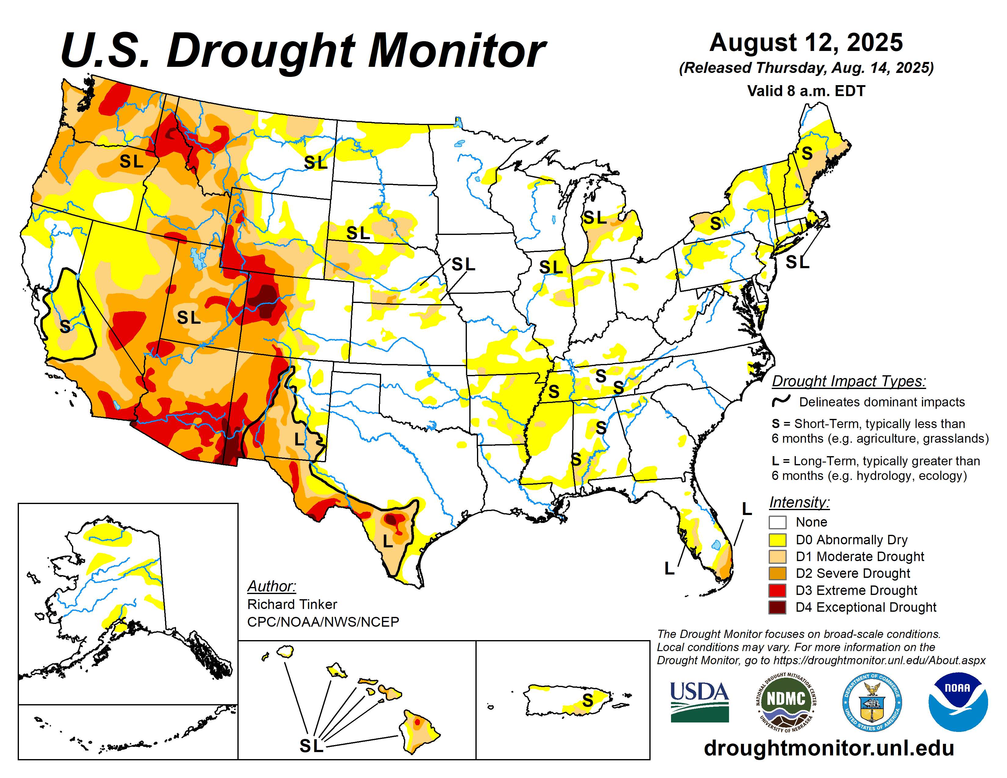
The latest drought monitor shows wide areas of drought in the western US, spreading eastward and encompassing parts of the midwest. Serious drought remains in parts of New England. Generous rains of 2-4 inches this week in the Ohio valley all but eliminated drought conditions and brought saturated soils to most.
National drought summary>>>

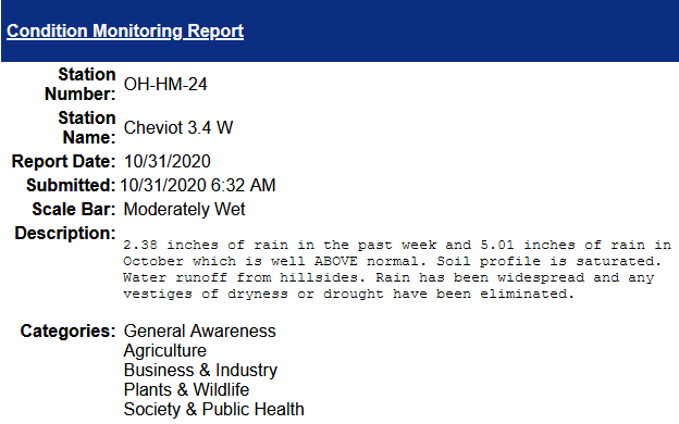
This report is specifically for the Arbor Doctor’s location 3.4 miles west of Cheviot, OH, in the western suburbs of Cincinnati in southwest Ohio. This location is also an official cooperative observation site for the National Weather Service listed as Cheviot 3W.

What is the Condition Monitoring Report? See these links for more information:

Explanation of scale bar>>>

Search condition monitoring reports for the entire US>>>  

Interactive

Condition Monitoring

Static

Watershed Maps


Please remember to water…correctly!

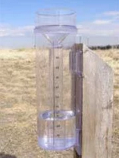
Water once per week, one inch per week, under the entire branch spread, in the absence of rain, May through November. Either rainfall or your watering should equal the one inch per week. Put out a sprinkler and a straight sided soup can or rain gauge and measure one inch per week.


Drought:                                                                                                                     >>>


1-inch capacity rain gauge  >>>

Taylor rain gauge   >>>

Watering: How and when>>>

Watering Trees and Shrubs>>>


Soil Moisture Index:

Meteorological Versus Astronomical Seasons

Spring: March 1-May 31; Summer: June 1-August 31; Fall: September 1-November 30; Winter: December 1-February 28 (29)


You may have noticed that Arbor Doctor, meteorologists and climatologists define seasons differently from “regular” or astronomical spring, summer, fall, and winter. So, why do  meteorological and astronomical seasons begin and end at different times? Climatologically, the period July 14-21, the mid-point of meteorological summer, is the hottest week of the year and the period January 14-21, the mid-point of meteorological winter, is the coldest week of the year over much of the continental US including the Ohio valley.

Read more here>>>

Another hurricane, a winter storm, an ice storm, flooding rains, and a nice Halloween weekend.

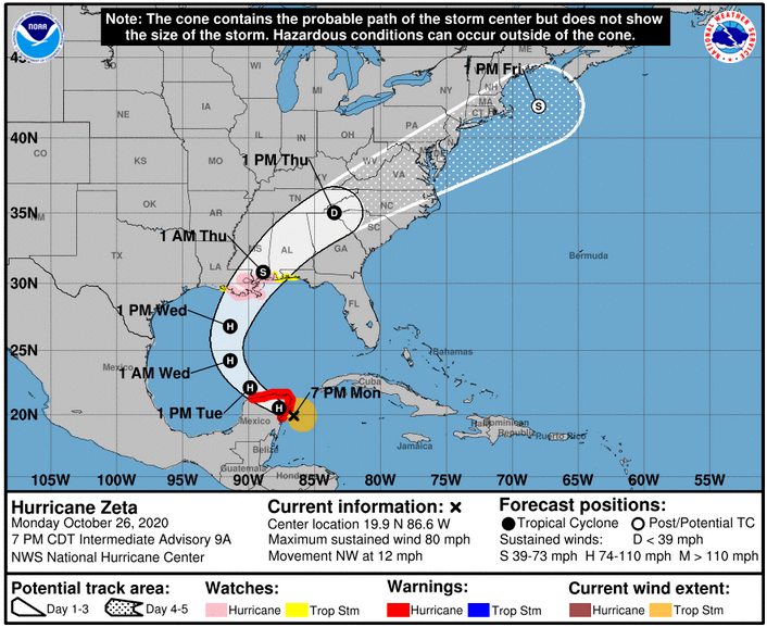
Two weeks ago computer models began hinting at an east coast storm or hurricane which would strike near Halloween then pull down cold air. Hurricane Zeta has formed but it will move a bit farther west than first thought.

Hurricane conditions and dangerous storm surge are expected in portions of the northern Yucatan Peninsula of Mexico through early Tuesday. Through  Tuesday, heavy rainfall is expected across the Yucatan Peninsula, the Cayman Islands, and central to western Cuba, which could lead to flash flooding in urban areas.

Hurricane conditions and life-threatening storm surge are possible along portions of the northern Gulf Coast on Wednesday, and Storm Surge and Hurricane Watches are in effect. Residents in the watch areas should follow any advice given by local officials.

Meanwhile, a winter storm has settled into New Mexico, west Texas, and Oklahoma with winter storm and ice storm warnings, as well as winter weather advisories all the way south to the US-Mexico border.

After Zeta makes landfall, it will be shunted northeastward through the Tennessee valley and off the east coast while the southern plains low pivots eastward. The combination of Zeta moving in from the south and the southern plains low moving east will produce two swaths of very heavy rains, one from Louisiana into the Blue Ridge mountains and the other from Oklahoma and Kansas eastward into the Ohio valley, the mid-Atlantic and southern New England.

5 day Rainfall (melted snow) Forecast:p120i.gif (750×562)

Rain and possibly a few thunderstorms will be in the offing for Thursday in the Ohio valley with significant rainfall amounts of 2-3″ expected, locally higher. The forecast is too far out to hone in on the specifics, but a steady moderate to heavy rainfall with some stronger showery elements will get wrung out along a warm front that will stall between the I-70 corridor and the Ohio River.

Between Tuesday night and Thursday, heavy rainfall is expected from portions of the central Gulf Coast into the southern Appalachians and Mid-Atlantic States near and in advance of Zeta. This rainfall will lead to flash, urban, small stream, and minor river flooding.

The good news is two fold. First, the more east to west trajectory will not drag down as much cold air. Second, all this will progress off the coast bringing a beautiful Halloween weekend to much of the country.

As we look ahead to early November, it is looking like a warming trend for much of the country as well as a return to dry weather.

8-14 Day Outlook:

Temperature Probability8 to 14 Day Outlook - Temperature Probability
Precipitation Probability8 to 14 Day Outlook - Precipitation Probability


Soil Moisture Condition Monitoring Weekly Report: Near Normal. A major dent in the Ohio valley drought and more rain is on the way. Ultimately, it will turn cold toward Halloween.

United States Drought Monitor


The latest drought monitor shows wide areas of drought in the western US, spreading eastward and encompassing parts of the midwest. There is serious drought in parts of New England. In Ohio, northwest Ohio has been in moderate drought and parts of southwest Ohio are now in moderate drought.

National drought summary>>>

A major dent in the Ohio valley drought and more rain is on the way. Ultimately, it will turn cold toward Halloween>>>

Station Number: OH-HM-24
Station Name: Cheviot 3.4 W
Report Date: 10/24/2020
Submitted: 10/24/2020 6:24 AM
Scale Bar: Near Normal
Description:

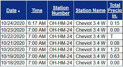
2.09 inches of rain in the past week put a major dent in the developing drought. Soil is moist although entire soil profile has not been saturated. Lawns have mostly recovered and are green. Stream flow increased some this week during the rains but is still somewhat low. Pretty close to normal for fall in Cincinnati.

Categories:
General Awareness
Agriculture
Business & Industry
Plants & Wildlife
Society & Public Health

This report is specifically for the Arbor Doctor’s location 3.4 miles west of Cheviot, OH, in the western suburbs of Cincinnati in southwest Ohio. This location is also an official cooperative observation site for the National Weather Service listed as Cheviot 3W.

What is the Condition Monitoring Report? See these links for more information:

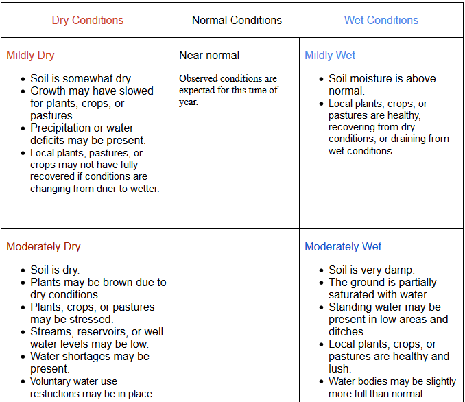
Explanation of scale bar>>>
Search condition monitoring reports for the entire US>>>  

Interactive

Condition Monitoring

Static

Watershed Maps


Please remember to water…correctly!

Water once per week, one inch per week, under the entire branch spread, in the absence of rain, May through November. Either rainfall or your watering should equal the one inch per week. Put out a sprinkler and a straight sided soup can or rain gauge and measure one inch per week.


Drought:                                                                                                                     >>>


1-inch capacity rain gauge  >>>

Taylor rain gauge   >>>

Watering: How and when>>>

Watering Trees and Shrubs>>>


Soil Moisture Index:

Meteorological Versus Astronomical Seasons

Spring: March 1-May 31; Summer: June 1-August 31; Fall: September 1-November 30; Winter: December 1-February 28 (29)


You may have noticed that Arbor Doctor, meteorologists and climatologists define seasons differently from “regular” or astronomical spring, summer, fall, and winter. So, why do  meteorological and astronomical seasons begin and end at different times? Climatologically, the period July 14-21, the mid-point of meteorological summer, is the hottest week of the year and the period January 14-21, the mid-point of meteorological winter, is the coldest week of the year over much of the continental US including the Ohio valley.

Read more here>>>