Severe weather will be possible Sunday afternoon and evening. Damaging winds will be the primary threat, however isolated large hail, flash flooding, and a few tornadoes will also be possible.

Severe weather will be possible Sunday afternoon and evening. Damaging winds will be the primary threat, however isolated large hail, flash flooding, and a few tornadoes will also be possible.


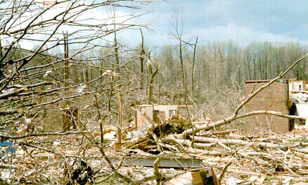
Although damage occurred at multiple locations throughout the Tri-State area, the most severe damage occurred in the vicinity of Blue Ash and Symmes Townships in northeastern Hamilton County, OH. At various points within the survey, it was concluded that the tornado temporarily reached F4 status, which at that time indicated wind speeds approached or even exceeded 200 MPH. Unfortunately, the storm claimed 4 lives that morning.
Station Number: OH-HM-24
Station Name: Cheviot 3.4 W
Report Date: 4/6/2019
Submitted: 4/06/2019 7:04 AM
Scale Bar: Moderately Wet
Description:
1.86 inches of rain over the past week, most falling 6 and 7 days ago. Soil is very damp. The ground is partially saturated with water. Standing water is present in low areas and ditches. Lawns are healthy and lush. Water bodies are slightly more full than normal.
Categories:
General Awareness
Agriculture
Plants & Wildlife
This report is specifically for the Arbor Doctor’s location 3.4 miles west of Cheviot, OH, in the western suburbs of Cincinnati in southwest Ohio. This location is also an official cooperative observation site for the National Weather Service listed as Cheviot 3W.
What is the Condition Monitoring Report? See these links for more information: