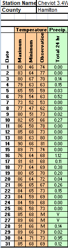
Station Number: OH-HM-24
Station Name: Cheviot 3.4 W
Report Date: 5/25/2019
Submitted: 5/25/2019 6:35 AM
Scale Bar: Mildly Wet
Description:
1.19 inches of rain during the past week with above normal temperatures and drying rates. Soil moisture is above normal. Local plants, crops, or pastures are healthy and lush.
Categories: General Awareness
Agriculture
Plants & Wildlife
–
This report is specifically for the Arbor Doctor’s location 3.4 miles west of Cheviot, OH, in the western suburbs of Cincinnati in southwest Ohio. This location is also an official cooperative observation site for the National Weather Service listed as Cheviot 3W.
What is the Condition Monitoring Report? See these links for more information:
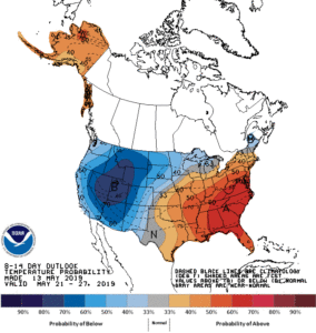 The Bermuda high will force a bit of a traffic jam in the atmosphere. While there will be occasional rain chances in Cincinnati, it looks like a much drier pattern is developing in the east. A very cold and wintery pattern is setting up in the west with frequent, flooding rains and storms in the nation’s mid-section.