
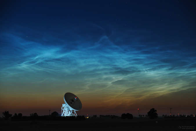
June 19, 2019: The 2019 season for noctilucent clouds (NLCs) has been remarkable, maybe the best ever, with NLCs appearing as far south as Los Angeles CA and Albuquerque NM. What’s going on?
Potential for more flash flooding, isolated severe storms, severe wind gusts, and an isolated tornado Sunday afternoon and evening with an isolated flash flood threat and severe storm threat again Monday

Hazardous Weather Outlook
National Weather Service Wilmington OH
435 AM EDT Sun Jun 23 2019
Wayne-Fayette IN-Union IN-Franklin IN-Ripley-Dearborn-Hardin-Mercer-
Auglaize-Darke-Shelby-Logan-Miami-Preble-Montgomery-Butler-Hamilton-
435 AM EDT Sun Jun 23 2019
This Hazardous Weather Outlook is for East Central Indiana,
Southeast Indiana, Southwest Ohio and West Central Ohio.
.DAY ONE…Today and tonight.
Thunderstorms will move into the area late this afternoon into this
evening. There will be the potential for flash flooding due to
rainfall falling on already saturated ground. In addition to a
renewed flooding threat, storms will have the potential to produce
damaging winds. An isolated tornado will also be possible late this
afternoon into the evening hours.
1-3 Day Rainfall (melted snow) Forecast:

.DAYS TWO THROUGH SEVEN…Monday through Saturday.
Thunderstorms will move across the region on Monday in advance of a
cold front. Soils will still be extremely moist from recent rains,
thus any storms moving continually over the same area will pose a
flash flood threat. In addition to the renewed flooding threat,
storms could produce damaging winds.
Soil Moisture Condition Monitoring Weekly Report: Severely Wet
Station Number: OH-HM-24
Station Name: Cheviot 3.4 W
Report Date: 6/16/2019
Submitted: 6/16/2019 7:22 AM
Scale Bar: Severely Wet
Description:
4.63 inches of rain in the past 7 days. 3.71 inches of rain in the past 24 hours. Widespread high water. Fields and yards are flooded.
Categories:
General Awareness
Agriculture
Plants & Wildlife
–
This report is specifically for the Arbor Doctor’s location 3.4 miles west of Cheviot, OH, in the western suburbs of Cincinnati in southwest Ohio. This location is also an official cooperative observation site for the National Weather Service listed as Cheviot 3W.
What is the Condition Monitoring Report? See these links for more information: