Extended period of wet weather and potential excessive rainfall in the Ohio valley over the next week or two.

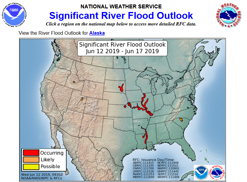
Rainfall of 2-4 inches is possible over the next week in the Ohio and mid-Mississippi valley with above normal rainfall forecast over the next 14 days.

7 day rainfall outlook:

Day 9 image not available
6-10 day rainfall outlook:

6 to 10 Day Outlook - Precipitation Probability

8-14 day rainfall outlook:

8 to 14 Day Outlook - Precipitation Probability

Widespread flooding over the Mississippi valley will only be aggravated by this heavy rainfall pattern.

Today’s Convective (Severe Weather) Outlooks:

Updated: Tue Mar 24 16:31:57 UTC 2015
Current Convective Outlooks
Current Day 1 Outlook1630 UTC Day 1 Outlook Forecaster: BUNTING/MEAD/COHEN Issued: 24/1627Z Valid: 24/1630Z – 25/1200Z Forecast Risk of Severe Storms: Enhanced Risk
Current Day 2 Outlook0600 UTC Day 2 Outlook Forecaster: DARROW Issued: 24/0440Z Valid: 25/1200Z – 26/1200Z Forecast Risk of Severe Storms: Enhanced Risk
Current Day 3 Outlook0600 UTC Day 3 Outlook Forecaster: DARROW Issued: 24/0702Z Valid: 26/1200Z – 27/1200Z Forecast Risk of Severe Storms: No Svr Tstms
Current Day 4-8 Outlook
Day 4-8 Convective Outlook
Forecaster: Jewell
Issued: 15/0842Z
Valid: Sat 05/18 1200Z – Wed 05/22 1200Z
Note: A severe weather area depicted in the Day 4-8 period indicates a 15%, 30% or higher probability for severe thunderstorms (e.g. a 15%, 30% chance that a severe

Soil Moisture Condition Monitoring Weekly Report: Near Normal

Station Number: OH-HM-24
Station Name: Cheviot 3.4 W
Report Date: 6/8/2019
Submitted: 6/08/2019 6:46 AM
Scale Bar: Near Normal
Description:

0.90 inch of rain in the past week in a single thunderstorm. Local plants, crops, are healthy.

Categories: General Awareness
Agriculture
Plants & Wildlife

This report is specifically for the Arbor Doctor’s location 3.4 miles west of Cheviot, OH, in the western suburbs of Cincinnati in southwest Ohio. This location is also an official cooperative observation site for the National Weather Service listed as Cheviot 3W.

What is the Condition Monitoring Report? See these links for more information:

Explanation of scale bar>>>

Search condition monitoring reports for the entire US>>>

May 2019. Above normal temperatures, no frost or freeze, normal rainfall, and The Tornado Outbreak.

May 2019 will largely be remembered for the tornado outbreak that occurred on May 27th-28th. In addition to the tornado outbreak, severe weather occurred on several other days throughout the month as well. Although some below normal temperature days occurred, two-thirds of the month was above normal. In addition, this year had an early end to frost and freezing temperatures. Temperatures at Dayton, Columbus, and Cincinnati had their lowest temperatures only dropping into the 40s. View the summary report here>>>