Soil Moisture Condition Monitoring Weekly Report: Severely Dry

Station Number: OH-HM-24
Station Name: Cheviot 3.4 W
Report Date: 9/28/2019
Submitted: 9/28/2019 6:21 AM
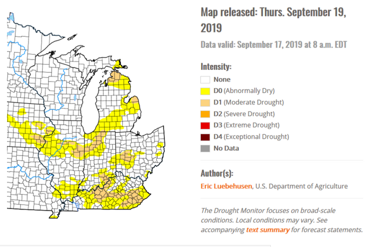
Scale Bar: Severely Dry
Description:

0.12 inches of rain in the past 7 days and in the past 26 days. September rainfall 0.79. Mid-summer and record heat, high drying rates. Soil moisture is absent in many areas. Lawns are increasingly drought stressed. Drought stress showing up in trees, shrubs, landscape plants. Enhanced fire danger at times this week.

Categories:
General Awareness
Agriculture
Fire
Plants & Wildlife
Society & Public Health
Water Supply & Quality

This report is specifically for the Arbor Doctor’s location 3.4 miles west of Cheviot, OH, in the western suburbs of Cincinnati in southwest Ohio. This location is also an official cooperative observation site for the National Weather Service listed as Cheviot 3W.

What is the Condition Monitoring Report? See these links for more information:

Explanation of scale bar>>>

Search condition monitoring reports for the entire US>>>

Please remember to water…correctly!


A September to remember (or forget). Abnormally dry and warm weather this month, challenging all time records.

Well, it’s shaping up to be a September to remember for the local area with abnormally dry and warm conditions thus far. In fact, the heat will only expand thru the final part of September as we roll into October next week. Daily and even monthly record highs may be in jeopardy early next week (for the start of October!)

After Friday morning’s fall-like start, temps trend very warm across the area into the weekend and early Oct. Daily lows are forecast to be only a few degrees away from normal high temps. But wait, there’s more! All-time monthly high records for Oct. may also be tied or broken!

The drought monitor update Thursday morning shows Moderate Drought increasing in size. Over the next week, high pressure favors dry weather as heavier precipitation occurs north and west of our local area. Please follow local burn restrictions as we await more substantial rainfall.

Please remember to water…correctly!


Yes, we know it’s fall, but near record heat wave is on the way, again, and drought is developing and expanding

Subtropical high pressure will build into the Ohio Valley late this weekend into next week. This feature will offer hot weather to the region. Here is a table containing the forecast high temperatures and records.

Station Number: OH-HM-24
Station Name: Cheviot 3.4 W
Report Date: 9/21/2019
Submitted: 9/21/2019 6:35 AM
Scale Bar: Moderately Dry
Description:

No measurable rain for almost 3 weeks. Hot weather over the past 2 weeks with temperatures much above normal and high drying rates. Ground is very dry. Lawn drought stress is worsening. Trees and shrubs are showing drought stress. Streams are very low or drying up.

Categories:
General Awareness
Agriculture
Plants & Wildlife
Water Supply & Quality

This report is specifically for the Arbor Doctor’s location 3.4 miles west of Cheviot, OH, in the western suburbs of Cincinnati in southwest Ohio. This location is also an official cooperative observation site for the National Weather Service listed as Cheviot 3W.

What is the Condition Monitoring Report? See these links for more information:

Explanation of scale bar>>>

Search condition monitoring reports for the entire US>>>

Please remember to water…correctly!