
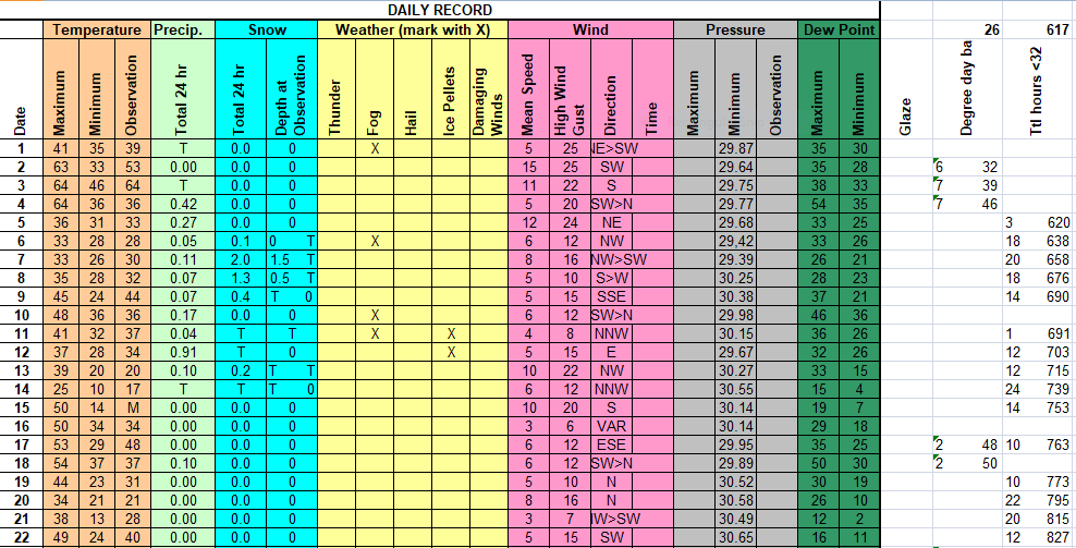
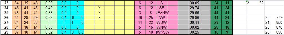
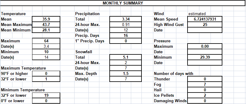
February 2020 was the wintriest month of the 2019-2020 meteorological winter. While the temperature departure was +1.4 degrees F, this paled in comparison to the December departure of +6.0 degrees F and the January departure of +7.0 degrees F. February snowfall of 5.1 inches was slightly above normal and at month’s end seasonal snowfall was near normal with a departure of +0.1 inch. February was the only month in meteorological winter with above normal snowfall but the season total was boosted by above normal snowfall in November. Liquid and melted precipitation was 3.34 inches which is about a third of an inch above normal. The month’s snows came in spurts with most morning snow being melted by each day’s end. Only one day saw snow cover of 1 inch or greater, the 7th, and even that didn’t stick around until evening.
1: Cloudy. Morning fog and intermittent drizzle. Cloudy PM with a little drizzle. Gusty shower 1630. Cloudy evening.
2:Clear at AM obs. Sunny, very warm, windy.
3: High clouds thickening and lowering. Sprinkles 2030-2100. 4: -RA at AM obs. Intermittent light rain. Period of moderate rain 1730. Very warm, then windy and sharply colder after dark. Drizzle at evening obs.
5: Rain ending overnight. Cloudy, light drizzle, much cooler at AM obs. Cloudy, cool, breezy day. Rain 1700 to 2000, then drizzle, cold, breezy.
6: Drizzle ending overnight. Cloudy at AM obs. Cloudy with light fog and occasional light drizzle and freezing drizzle. Mixing with ice pellets late then periods of -SN and FZ -DZ. 7: Light snow overnight and at morning obs. Snow tapering by 0900 and ending by 1100 then partly cloudy, chilly. Considerable snow melt due to warm ground.
8: -SN developing overnight with -SN and graupel at AM obs. -SN ending by 0800. SN 0900-1130, then some clearing, followed by more clouds. Light snow and flurries 1530-evening obs.
9: Cloudy at AM obs. Cloudy, breezy, chilly. Heavy snow 1335-1400. Turning warmer. Light rain 1830 to evening obs.
10: Intermittent light rain overnight and at AM obs. Breezy, warm. Drizzle and light fog through PM obs. Turning sharply colder in AM and remaining chilly. 11: Ice pellets overnight then cold, light rain. Mix of Drizzle and snow grains, and a little snow, ending by 1100, then slow clearing. Light fog and haze.
12: Cloudy, frosty at AM obs. Rain after 1230, mixed with a few ice pellets at the outset. Rain gradually increasing in intensity with moderate to heavy rain 1730 to 1930 13: Intermittent light rain overnight changing to light snow with snow at AM obs. Snow ending by 0800. A few morning flurries then becoming partly cloudy. Cloudy PM. Flurries 1500, Snow shower 1550. -SN rest of PM and at evening obs, windy and sharply colder.
14: Flurries overnight and at AM obs. Flurries ending by 1100. Mostly sunny with fair weather Cu. Very cold.
15: Clear, frosty at AM obs. Mostly sunny, breezy, turning milder. 16: Cloudy, with clearing late. Warm. 17: Increasing and thickening clouds. Warm. 18: -RA at AM obs. -RA ending by 0930 then cloudy, warm AM with slowly falling temperatures in PM.
19: Clear and frosty at AM obs. Mostly sunny. Cool AM, milder PM. 20: Becoming sunny, cold, breezy. 21: Frosty start, sunny, cold.
22: Cold start, then sunny, breezy, warmer. 23: Considerable clouds, warm.
24: -RA 0730-1130, then cloudy with occasional sprinkles and -DZ. RA 1530-2000, then DZ FG.
25: -RA -FG overnight. Cloudy at AM obs. Continual drizzle and light fog. Fog, mist at PM obs.
26: Light fog, mist at AM obs. AM DZ FG, then RA changing to wet SN by midday. Period of moderate wet SN, then light wet SN the rest of the day. Evening windy with light SN. No daytime accumulation, dusting after dark. 27: Flurries overnight and at AM obs. Considerable clouds with flurries gradually ending. Cold.
28: Snow overnight, melting on pavement then re-freezing. Mostly cloudy at AM obs and very icy. Partly sunny day. Flurries 1550 to 1630, then a period of snow.
29: Sunny, cold.