A wet weather roller coaster as we say good riddance to 2020 and hello to 2021.

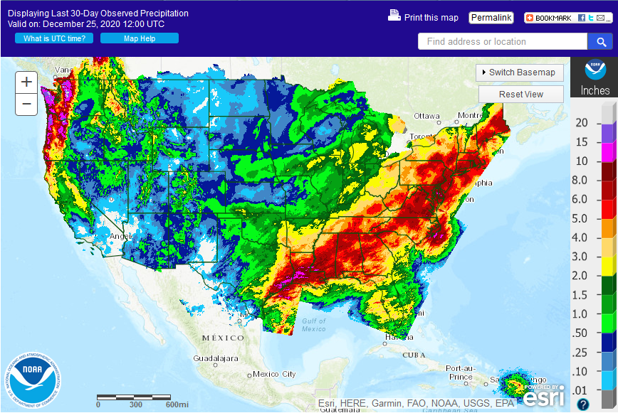
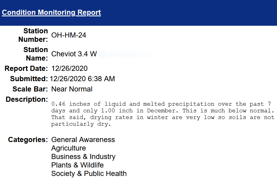
In Cincinnati, we will be on a weather roller coaster with cool rain Wednesday afternoon, a rain-snow mix Thursday morning, and much warmer rain Thursday night into New Year Day, then turning cooler again. Minor snow accumulations cannot be ruled out Thursday morning, mainly on grassy surfaces. Overall rainfall amounts by week’s end could approach 2 inches. Flooding concerns should be fairly minimal since only 1 inch of rain has fallen in December which is well below normal.


Soil Moisture, Drought, and Condition Monitoring. Western drought, drought in central Illinois and northwest Indiana, improving in much of the east. Near normal in Cincinnati.

Soil Moisture Condition Monitoring Weekly Report for Cheviot OH 3.4W:  Near Normal

This report is specifically for the Arbor Doctor’s location 3.4 miles west of Cheviot, OH, in the western suburbs of Cincinnati in southwest Ohio. This location is also an official cooperative observation site for the National Weather Service listed as Cheviot 3W.

What is the Condition Monitoring Report? See these links for more information:

Explanation of scale bar>>>

Search condition monitoring reports for the entire US>>>  

Interactive

Condition Monitoring

Static

Watershed Maps

Please remember to water…correctly!

Water once per week, one inch per week, under the entire branch spread, in the absence of rain, May through November. Either rainfall or your watering should equal the one inch per week. Put out a sprinkler and a straight sided soup can or rain gauge and measure one inch per week.

To the extent possible recycle falling leaves back into the soil around the trees and maintain mulch around the trees to a radius of at least 3-5 feet. Keep mulch off trunks. Use a coarse textured mulch. Avoid triple shredded mulch.

Drought: How Dry Seasons Affect Woody Plants                                                                                                                     >>>


1-inch capacity rain gauge  >>>

Taylor rain gauge   >>>

Watering: How and when>>>

Watering Trees and Shrubs>>>


Soil Moisture Index:

National drought summary>>>

Last Week Drought Change
U.S. Drought Monitor Percent Area in Continental U.S. - Weekly Change Map
 

Last Month Drought Change

U.S. Drought Monitor Percent Area in Continental U.S. - Monthly Change Map

Meteorological Versus Astronomical Seasons

Spring: March 1-May 31; Summer: June 1-August 31; Fall: September 1-November 30; Winter: December 1-February 28 (29)


You may have noticed that Arbor Doctor, meteorologists and climatologists define seasons differently from “regular” or astronomical spring, summer, fall, and winter. So, why do  meteorological and astronomical seasons begin and end at different times? Climatologically, the period July 14-21, the mid-point of meteorological summer, is the hottest week of the year and the period January 14-21, the mid-point of meteorological winter, is the coldest week of the year over much of the continental US including the Ohio valley.

Read more here>>>

Nearly half the country has had its coldest day by the first day of calendar winter. That is why meteorological winter makes the most sense.

White Christmas can be found on the Arbor Doctor Weather Links, Resources and Webcams Page even if it cannot be found in your own back yard.

Here are white Christmases on several of the websites on our Weather Links, Resources and Webcams webpage:

https://youtu.be/kLEEotv2Oaw

Crater Lake, OR>>>

Glacier National Park >>>

Mount Rainier National Park>>>

Perfect North Slopes>>>

Seven Springs Ski Resort Pennsylvania>>>

Snowshoe, West Virginia Ski Resort webcams >>>

South Pole Live Camera>>>

Covered Bridge Webcam from Vermont’s Mad River Valley>>>

Vermont, Live view of the Warren Store>>>

May your days be merry and bright, and may all your Christmases be white!