
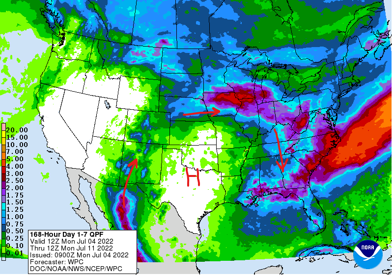
The 2022 “Ring Of Fire” pattern can clearly be seen in this recent precipitation outlook map.
Recently a colleague asked me why Cincinnati has gotten such wild storms this spring and summer. Like many arborists, he has been slammed with tree storm damage calls and was wondering if this is global warming induced.
The global warming question is always a tough one since it involves long term climate trends. What I was able to share with him was that there is really nothing particularly odd about the weather pattern this year.
Every season, and every year, is different. Weather patterns are governed by infinitely complex influences including ocean temperature fluxuations and jet stream anomalies. What happens in the middle east and Pacific Ocean can and often does ultimately affect the weather in North America.
This year, a strong high pressure ridge developed over Texas and has remained in place for much of the summer thus far. Low pressure troughs to its west and east have actually fed this high pressure ridge which produces hot, dry air at its core.
Around the periphery of this high pressure ridge moisture is fed up and over the ridge. This effect is nothing new and is often referred to by meteorologists as the “Ring Of Fire” since thunderstorm complexes develop in this moisture transport. As thunderstorm complexes top the ridge and begin moving southeastward into the extremely hot, humid environments, they sometimes grow into long loved thunderstorm complexes called Mesoscale Convective Systems, defined as “a complex of thunderstorms which becomes organized on a scale larger than the individual thunderstorms, and normally persists for several hours or more. MCSs may be round or linear in shape, and include systems such as tropical cyclones, squall lines, and Mesoscale Convective Complexes (MCCs) (among others). ”
When thunderstorms intensify and rapidly cool the air in a very hot, humid environment, these MCS thunderstorms can sometimes develop into long lived derechos. A derecho is defined as “a widespread and usually fast-moving windstorm associated with convection. Derechos include any family of downburst clusters produced by an extratropical MCS, and can produce damaging straight-line winds over areas hundreds of miles long and more than 100 miles across.” One of the most intense derechos in recent memory produced major devestation in Iowa on August 10, 2020.
While not technically a hurricane, derechos have been referred to as “inland hurricanes” as is clearly demonstrated by this video of the August 10, 2020, derecho in Cedar Rapids, Iowa, which was exceptionally powerful with peak wind gusts estimated by the National Weather Service of 110-140 mph.
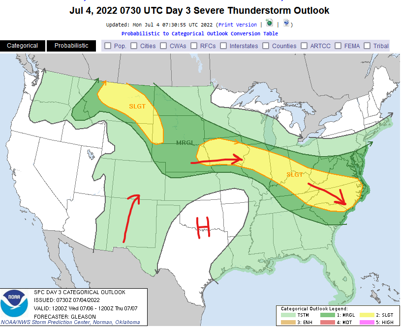
As we move through July, this “Ring Of Fire” pattern is forecast to continue. In fact, the July 4 severe weather outlook clearly shows the potential for severe thunderstorm complexes riding down the northeast side of the “Ring Of Fire”.
For more in depth information on Mesoscale Convective Systems: