Severe storm potential Friday night, next week and beyond in favorable weather pattern for severe storms and tornadoes.

A robust system will move across the region Friday into Saturday. This will bring the potential for some strong to severe thunderstorms Friday night. Strong non-thunderstorms winds can be expected on Saturday.

Hatched Area: 10% or greater probability of EF2 – EF5 tornadoes within 25 miles of a point.

Another widespread severe weather outbreak may occur next week.

The overall weather pattern this spring favors severe storms and tornadoes from the Great Plains through the Mississippi, Tennessee, and Ohio River valleys and the southeast US. We have already seen numerous destructive tornadoes this year in this weather pattern. With cold air to the northwest and a jet stream guiding storms northward in the plains, pulling up juicy warm air from the Gulf of Mexico, a near ideal pattern is in place for a series of storms with severe storm and tornado potential.


March 26, 2023 Soil Moisture, Drought, and Condition Monitoring Report. Severely Wet conditions at Cheviot OH 3W. Drought conditions continue to diminish over much of the country except Florida and parts of the Gulf coast. Exceptional drought in the central plains and central Oregon.

.

This report is specifically for the Arbor Doctor’s location 3.4 miles west of Cheviot, OH, in the western suburbs of Cincinnati in southwest Ohio. This location is also an official cooperative observation site for the National Weather Service listed as Cheviot 3W.

What is the Condition Monitoring Report? See these links for more information:

Explanation of scale bar>>>

30 Day Precipitation:

.

Ohio 30-Day Precipitation

.

Search condition monitoring reports for the entire US>>>  

Interactive

Condition Monitoring

Static

Watershed Maps


United States Weekly Drought Monitor

Click on the title or the graphic (above) to access the
U.S. Weekly Drought MonitorPDF Version of Graphic Adobe PDF Reader

United States Monthly Drought Outlook

Click on the title or the graphic (above) to access the
U.S. Monthly Drought OutlookPDF Version of Graphic Adobe PDF Reader

United States Seasonal Drought Outlook

Click on the title or the graphic (above) to access the
U.S. Seasonal Drought OutlookPDF Version of Graphic

Adobe PDF Reader

Other Drought links:


Please remember to water…correctly!

Water once per week, one inch per week, under the entire branch spread, in the absence of rain, May through November. Either rainfall or your watering should equal the one inch per week. Do not water if the soil is already moist. Put out a sprinkler and a straight sided soup can or rain gauge and measure one inch per week. Measure the rainfall which falls in your yard. Your trees don’t care what fell at the airport!

If burlap was left on new trees, it will repel water and the tree or shrub may die. Be sure burlap and twine are removed from the top of all root balls. If your landscaper disagrees, refer him or her to the American National Standards Institute (ANSI) industry standard for installation of landscape plants.

To the extent possible recycle fallen leaves back into the soil around the trees and maintain mulch around the trees to a radius of at least 3-5 feet. Keep mulch off trunks. Use a coarse textured mulch. Avoid triple shredded mulch. Aged arborist wood chips, mulched and composted leaves, pine bark, and pine straw are all good. Very finely ground mulches such as triple ground hardwood mulch are not beneficial and may inhibit moisture and oxygen exchange.

Drought: How Dry Seasons Affect Woody Plants                                                                                                                     >>>


1-inch capacity rain gauge  >>>

Taylor rain gauge   >>>

Watering: How and when>>>

Watering Trees and Shrubs>>>


Meteorological Versus Astronomical Seasons

Spring: March 1-May 31; Summer: June 1-August 31; Fall: September 1-November 30; Winter: December 1-February 28 (29)


You may have noticed that Arbor Doctor, meteorologists and climatologists define seasons differently from “regular” or astronomical spring, summer, fall, and winter. So, why do  meteorological and astronomical seasons begin and end at different times? Climatologically, the period July 14-21, the mid-point of meteorological summer, is the hottest week of the year and the period January 14-21, the mid-point of meteorological winter, is the coldest week of the year over much of the continental US including the Ohio valley.

Read more here>>>

Nearly half the country has had its coldest day by the first day of calendar winter. That is why meteorological winter makes the most sense.

 –

Heavy rain and flooding forecast. Flood watch in effect

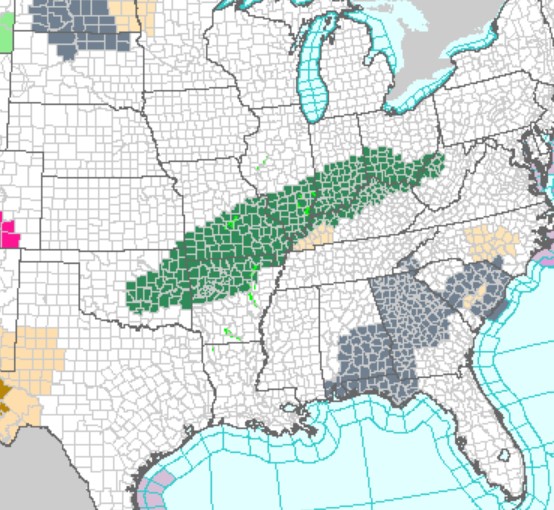
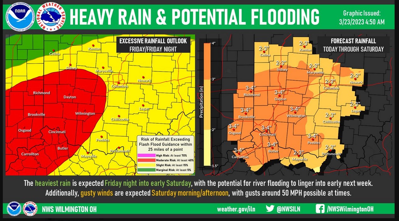
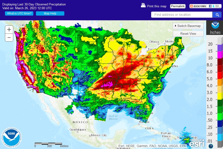
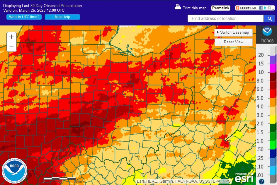
Flood watches are now in effect for an expansive area from eastern Oklahoma through most of the Ohio River valley including the entire Cincinnati tristate area.

….FLOOD WATCH REMAINS IN EFFECT FROM THIS EVENING THROUGH SATURDAY
AFTERNOON…

* WHAT…Flash flooding caused by excessive rainfall continues to be
possible.

* WHERE…For the following counties, in Indiana, Dearborn, Fayette
IN, Franklin IN, Ohio, Ripley, Switzerland, Union IN and Wayne. In
Northern Kentucky, Boone, Bracken, Campbell, Carroll, Gallatin,
Grant, Kenton, Owen, Pendleton and Robertson. In Ohio, Butler,
Clermont, Clinton, Greene, Hamilton, Montgomery, Preble and Warren.

* WHEN…From this evening through Saturday afternoon.

* IMPACTS…Excessive runoff may result in flooding of rivers,
creeks, streams, and other low-lying and flood-prone locations.

PRECAUTIONARY/PREPAREDNESS ACTIONS…

People in the watch area should keep an eye on the weather and be
prepared for immediate action should heavy rains and flooding occur
or a Flash Flood Warning be issued. Avoid low-lying areas and be
careful when approaching highway dips and underpasses.

.

Detailed Forecast
Today
Showers and thunderstorms likely before noon, then a chance of showers between noon and 3pm, then a chance of showers and thunderstorms after 3pm. Cloudy, with a high near 71. Breezy, with a southwest wind 18 to 21 mph, with gusts as high as 33 mph. Chance of precipitation is 60%. New rainfall amounts of less than a tenth of an inch, except higher amounts possible in thunderstorms.
Tonight
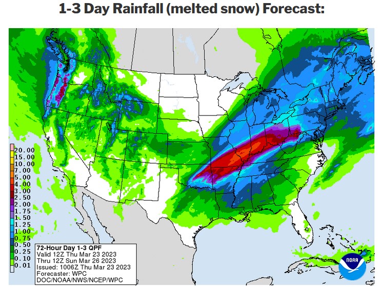
Showers and possibly a thunderstorm. Some of the storms could produce heavy rainfall. Low around 49. West wind 7 to 14 mph becoming northeast after midnight. Chance of precipitation is 100%. New rainfall amounts between three quarters and one inch possible.
Friday
Showers and possibly a thunderstorm before 7am, then showers between 7am and 9am, then showers and possibly a thunderstorm after 9am. Some of the storms could produce heavy rainfall. High near 53. Northeast wind 6 to 8 mph. Chance of precipitation is 100%. New rainfall amounts between three quarters and one inch possible.
Friday Night
Showers and possibly a thunderstorm. Some of the storms could produce heavy rain. Low around 50. East wind 10 to 17 mph becoming southeast after midnight. Chance of precipitation is 100%. New rainfall amounts between 1 and 2 inches possible.
Saturday
Showers likely and possibly a thunderstorm before 2pm, then a chance of showers and thunderstorms after 2pm. Some of the storms could produce heavy rain. Partly sunny, with a high near 65. Windy, with a southwest wind 18 to 23 mph increasing to 28 to 33 mph in the afternoon. Winds could gust as high as 49 mph. Chance of precipitation is 70%. New rainfall amounts between a tenth and quarter of an inch, except higher amounts possible in thunderstorms.

.