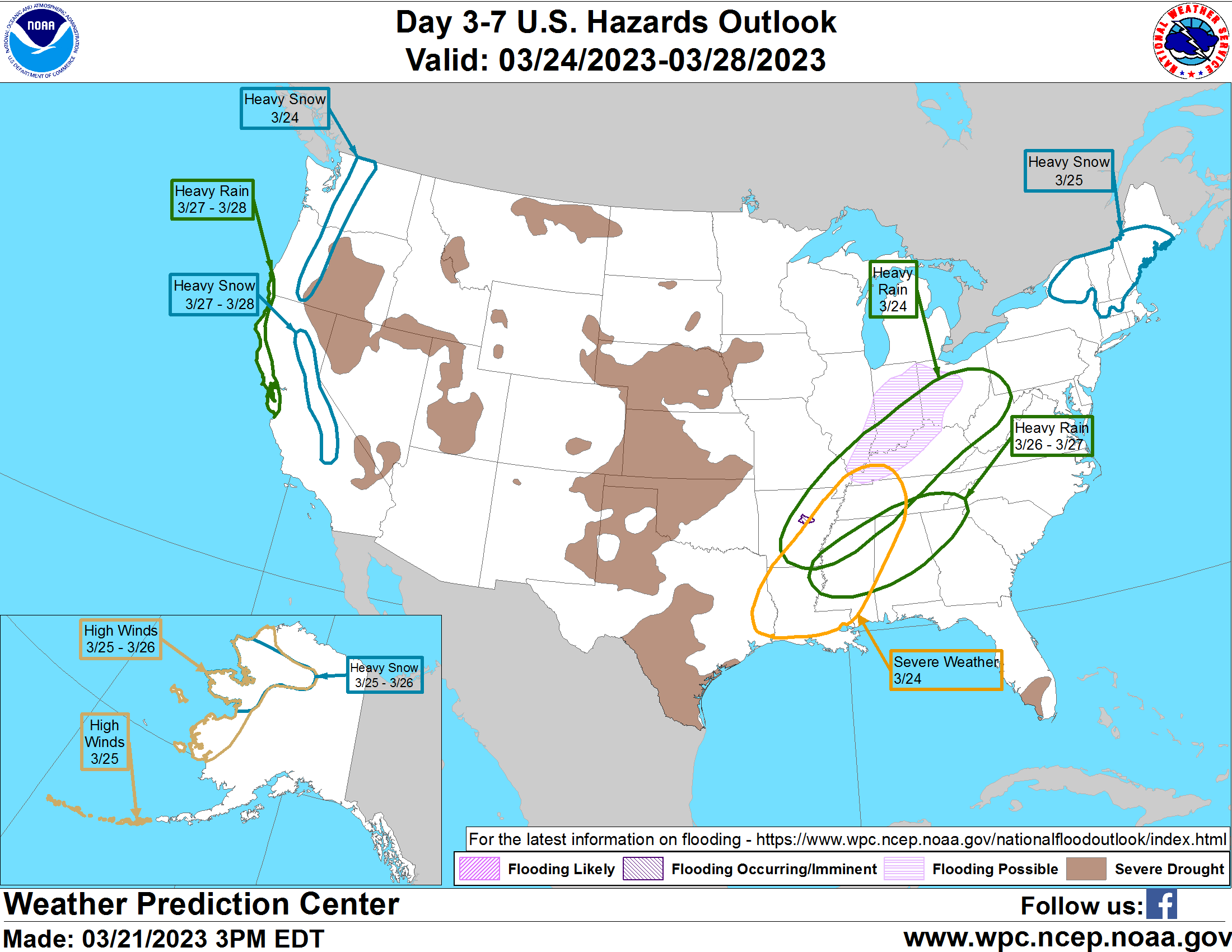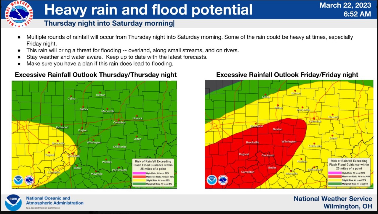
We continue to watch for the potential for heavy rain and flooding later this week. Rain Thursday night into Friday could result in some minor flooding. But it will also make the ground saturated for possibly heavier rain Friday night.
Risk of 1 to 6 hour rainfall exceeding flash flood guidance at a point
Updated: 0830 UTC Wed Mar 22, 2023
Valid: 12 UTC Mar 24, 2023 – 12 UTC Mar 25, 2023

Forecast Discussion
Excessive Rainfall Discussion
NWS Weather Prediction Center College Park MD
428 AM EDT Wed Mar 22 2023
Day 3
Valid 12Z Thu Mar 23 2023 – 12Z Fri Mar 24 2023
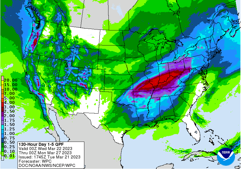
…THERE IS A MODERATE RISK FOR EXCESSIVE RAINFALL FROM THE OZARKS TO THE OHIO VALLEY…
Showers and thunderstorms will persist from the day 2 period in
proximity to the sprawling frontal boundary. Moisture convergence
will increase across parts of the Mississippi Valley and into the
Ohio Valley as a surface low pressure with trailing cold front
moves east across the Southern Plains. PW values will surge up to
1.5 inches (+2 to +2.5 Std dev) into the
Mississippi/Tennessee/Ohio Valleys. Repeating storms will track
across areas soaked from recent rains and will likely surpass
local FFGs early into the D3 period. The latest guidance depicts
several inches of rain to fall in a SW to Northeast orientation
with above average confidence. The EC ensemble means are showing a
sizable area from Arkansas to Ohio with a 20% probability of
exceeding 3 inches with a few speckles that have a 5% probability
of 5 or more inches of rain in a 24 hour period. This part of the
nation will be sensitive to additional rainfall, let alone a large
area with several inches of new accumulations. A Moderate Risk
area for excessive rainfall and flooding is now in effect from
northeast Arkansas to western Ohio. A Slight Risk stretches from
the Arkansas/Louisiana border to western Pennsylvania. A Marginal
Risk area covers eastern Texas to western Maryland.
Campbell