6 more weeks of winter? Yes, no, and maybe. The wild pattern continues for the rest of February.

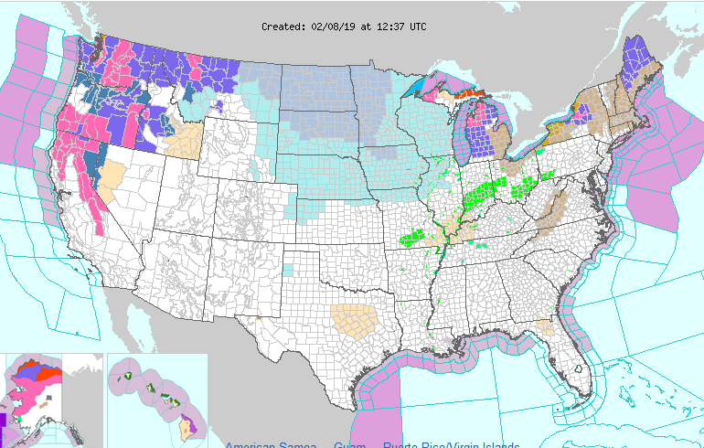
Yesterday it was 65 in Cincinnati, this morning it is 20. The promised return to winter is dominating the upper midwest, Great Lakes, and west as shown on this map. Winter storm warnings are up for the western mountains for a continual parade of winter storms while the blue shades in the upper midwest are wind chill advisories and warnings. The green in the Ohio valley is residual flooding concerns.

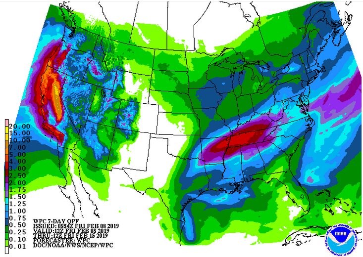
The 7 day liquid precipitation outlook shows storminess out west with an additional 10+ feet of snow possible in the Sierra Nevadas and more storminess in the southeast. Cincinnati will have a couple really cold, wintry days followed by several days of unsettled weather and precipitation. While no big snow is currently forecast, some accumulation cannot be ruled out from Sunday into next week.

The 6-10 day outlook shows real winter continuing in the northwest half of the country, spring-like weather in the southeast, and Cincinnati on the battleground border.

The battle between winter and spring will produce abundant storminess and precipitation where the two seasons meet. This means there is no end in sight to the precipitation train from the west coast into the Ohio valley and into New England. Precipitation type will depend on exactly where that battle line sits when any given storm goes through.

So, keep the snow shovel handy and the sump pump engaged. The wild February ride continues.


Strong to severe storms with damaging winds are possible late this afternoon through evening hours. We cannot rule out an isolated tornado as well. In addition, localized flooding continues to pose a threat today.

This Hazardous Weather Outlook is for East Central Indiana,
Southeast Indiana, Northeast Kentucky, Northern Kentucky, Central
Ohio, South Central Ohio, Southwest Ohio and West Central Ohio.

Patchy dense fog will dissipate this morning as rain spreads in. A
few strong to severe thunderstorms are possible this afternoon into
early this evening. Damaging wind gusts, either from straight line
winds or brief tornadoes is possible. After the precipitation ends,
strong gusty winds will occur overnight. Wind gusts of 35 to 45 mph
are possible.


Copious precipitation and possible flooding are becoming a concern, and possibly snow and ice eventually

As


As we move into February, a battleground is setting up between a strong, Bermuda-type, high pressure system over the southeast US and very cold, wintry air to the northwest.

The battle lines appear to be lining up along the Ohio and mid-Mississippi valleys. This will result in a quasi-stationary frontal system dividing the very warm air (it was 66 degrees Sunday in Cincinnati) from the arctic air to the northwest. Snowstorms will likely develop well to the north of this boundary while very heavy rains repeatedly move up the Ohio River valley.

With soils already saturated, flooding could become a concern. The five day liquid precipitation map above shows up to 4 inches of rain from near Cincinnati southwestward, and there will be more storminess after that. At some point, if the front slips a little further south, the parade of rain storms could turn into ice or snow storms, but that would be a couple weeks down the line if it occurs.

In the meantime, start building an ark. You’re going to need it.