Severe storms, damaging wind, and tornadoes expected Monday evening into the overnight from the lower Mississippi Valley into the Tennessee and Ohio Valleys.

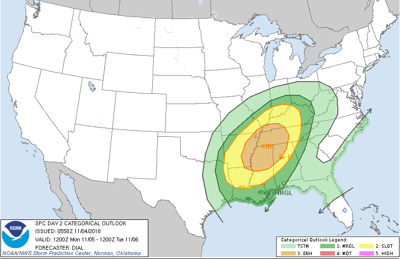
Day 2 Convective Outlook
NWS Storm Prediction Center Norman OK
1258 AM CDT Sun Nov 04 2018

Valid 051200Z – 061200Z

…THERE IS AN ENHANCED RISK OF SEVERE THUNDERSTORMS FROM THE LOWER MISSISSIPPI VALLEY INTO A PORTION OF THE TENNESSEE VALLEY…

…SUMMARY…
Numerous severe storms with potential for damaging wind and
tornadoes are expected Monday evening into the overnight from a
portion of the lower Mississippi Valley into the Tennessee and Ohio
Valleys.

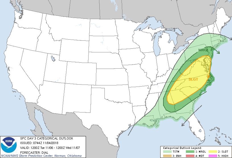
Day 3 Convective Outlook
NWS Storm Prediction Center Norman OK
0144 AM CST Sun Nov 04 2018

Valid 061200Z – 071200Z

…THERE IS A SLIGHT RISK OF SEVERE THUNDERSTORMS FROM A PORTION OF
THE SOUTHEAST STATES TO THE MIDDLE ATLANTIC REGION…

…SUMMARY…
A few strong to severe storms with locally strong wind gusts and
perhaps a couple of tornadoes will be possible from a portion of the
Southeast States to the Middle Atlantic region.

Soil Moisture Condition Monitoring Weekly Report: Moderately Wet

Station Number: OH-HM-24
Station Name: Cheviot 3.4 W
Report Date: 11/3/2018
Submitted: 11/03/2018 6:31 AM
Scale Bar: Moderately Wet
Description:

3.11 inches of rain in the past 7 days on top of dry soils. Soil is now wet. Ground is completely saturated with water. Standing water in low areas and ditches. Local plants, crops, and pastures are healthy and lush. Water bodies are more full than normal.

Categories:

General Awareness
Agriculture
Plants & Wildlife

This report is specifically for the Arbor Doctor’s location 3.4 miles west of Cheviot, OH, in the western suburbs of Cincinnati in southwest Ohio. This location is also an official cooperative observation site for the National Weather Service listed as Cheviot 3W.

What is the Condition Monitoring Report? See these links for more information:

Explanation of scale bar>>>

Search condition monitoring reports for the entire US>>>

New: Snow Squall Warnings to be issued by National Weather Service this season


Ever since driving in a sudden snow squall  in Columbus, OH while in college, I have contended that these sudden snow squalls, some of which produce only a quarter to half inch of accumulation but reduce visibility to zero and can glaze over roads in half the county in minutes, are the most dangerous winter weather hazard. I am thrilled to see the National Weather Service finally recognize this and take action on this. All I can add is this: if a snow squall warning is issued, take it seriously. It could be a matter of life or death if on the road.

WHAT

This is a new warning issued by the National Weather
Service. It is a polygon warning, generally
30-60 minutes in
duration, that is issued similar to severe thunderstorm and
tornado warnings.

WHEN

Begins November 1st.

WHY

A snow squall is an intense
short-lived burst of heavy snowfall
that leads to a quick reduction in visibilities and is often
accompanied by gusty winds. Sudden whiteout conditions and
slick roadways can lead to high speed accidents with large
pileups that result in injuries and fatalities. This new warning
aims to bring better situational awareness to drivers and
mitigate impacts related to these squalls.