
Station Number: OH-HM-24
Station Name: Cheviot 3.4 W
Report Date: 9/8/2018
Submitted: 9/08/2018 7:43 AM
Scale Bar: Severely Wet
Description:
5.49 inches of rain in the first 8 days of September, 12.96 inches of rain since August 1. Ground is completely saturated with water. Standing water is severe and abundant. Water bodies are very elevated. Significant flash flooding over the past week in the area. Heavy rains are ongoing. Wettest I have ever seen in late summer/early meteorological fall. Flooding may be leading to plant, crop, or pasture damage.
Categories: General Awareness
Agriculture
Plants & Wildlife
–
This report is specifically for the Arbor Doctor’s location 3.4 miles west of Cheviot, OH, in the western suburbs of Cincinnati in southwest Ohio. This location is also an official cooperative observation site for the National Weather Service listed as Cheviot 3W.
What is the Condition Monitoring Report? See these links for more information:
 Hazardous Weather Outlook
National Weather Service Wilmington OH
459 AM EDT Thu Sep 6 2018
Wayne-Fayette IN-Union IN-Franklin IN-Ripley-Dearborn-Ohio-
Switzerland-Carroll-Gallatin-Boone-Kenton-Campbell-Owen-Grant-
Pendleton-Bracken-Robertson-Mason-Lewis-Hardin-Mercer-Auglaize-Darke-
Shelby-Logan-Union OH-Delaware-Miami-Champaign-Clark-Madison-
Franklin OH-Licking-Preble-Montgomery-Greene-Fayette OH-Pickaway-
Fairfield-Butler-Warren-Clinton-Ross-Hocking-Hamilton-Clermont-Brown-
Highland-Adams-Pike-Scioto-
459 AM EDT Thu Sep 6 2018
This Hazardous Weather Outlook is for East Central Indiana,
Southeast Indiana, Northeast Kentucky, Northern Kentucky, Central
Ohio, South Central Ohio, Southwest Ohio and West Central Ohio.
.DAY ONE...Today and Tonight.
Scattered storms will develop today into this evening. Some of the
storms will contain very heavy rainfall with localized flooding
possible. A few of the stronger storms may produce strong wind gusts.
.DAYS TWO THROUGH SEVEN...Friday through Wednesday.
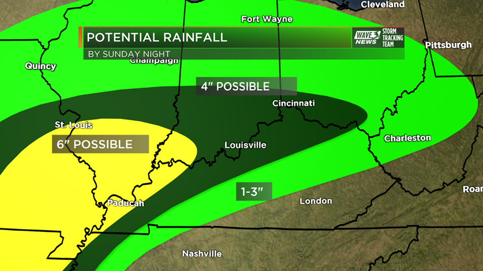
As remnants of tropical storm Gordon move into the Ohio Valley, the
potential for heavy rain will exist this weekend. At this time the
best threat for heavy rain looks to be Saturday night and Sunday.
Hazardous Weather Outlook
National Weather Service Wilmington OH
459 AM EDT Thu Sep 6 2018

Wayne-Fayette IN-Union IN-Franklin IN-Ripley-Dearborn-Ohio-
Switzerland-Carroll-Gallatin-Boone-Kenton-Campbell-Owen-Grant-
Pendleton-Bracken-Robertson-Mason-Lewis-Hardin-Mercer-Auglaize-Darke-
Shelby-Logan-Union OH-Delaware-Miami-Champaign-Clark-Madison-
Franklin OH-Licking-Preble-Montgomery-Greene-Fayette OH-Pickaway-
Fairfield-Butler-Warren-Clinton-Ross-Hocking-Hamilton-Clermont-Brown-
Highland-Adams-Pike-Scioto-
459 AM EDT Thu Sep 6 2018

This Hazardous Weather Outlook is for East Central Indiana,
Southeast Indiana, Northeast Kentucky, Northern Kentucky, Central
Ohio, South Central Ohio, Southwest Ohio and West Central Ohio.

.DAY ONE...Today and Tonight.
Scattered storms will develop today into this evening. Some of the
storms will contain very heavy rainfall with localized flooding
possible. A few of the stronger storms may produce strong wind gusts.

.DAYS TWO THROUGH SEVEN...Friday through Wednesday.
As remnants of tropical storm Gordon move into the Ohio Valley, the
potential for heavy rain will exist this weekend. At this time the
best threat for heavy rain looks to be Saturday night and Sunday.