SIGNIFICANT SEVERE STORM AND TORNADO RISK THIS AFTERNOON. WET WEEKEND ON TAP. PAY ATTENTION. SAME SYSTEM THAT RAKED IOWA YESTERDAY AND IT IS NOT CALMING DOWN

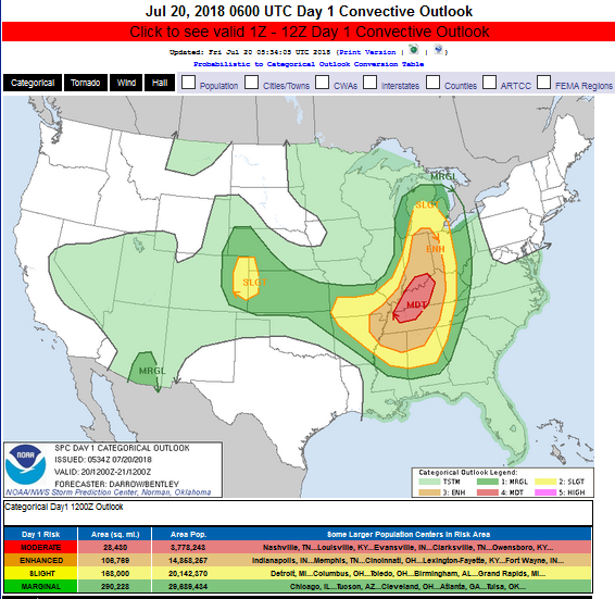
Day 1 Convective Outlook
NWS Storm Prediction Center Norman OK
1234 AM CDT Fri Jul 20 2018

Valid 201200Z – 211200Z

…THERE IS A MODERATE RISK OF SEVERE THUNDERSTORMS FROM WESTERN TN TO SOUTHERN IN…

…THERE IS A SLIGHT RISK OF SEVERE THUNDERSTORMS FROM LOWER MI TO MS AND AL…
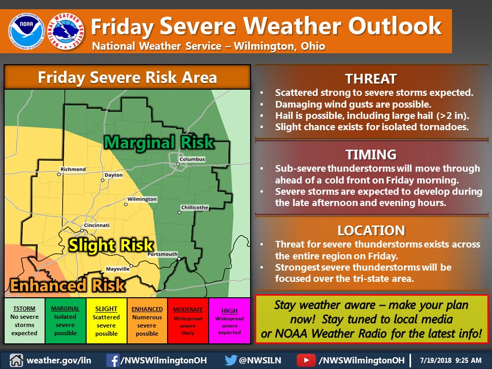
…SUMMARY…
Severe thunderstorms will develop across the Ohio and Tennessee
Valley region into the Mid-South Friday. Very large hail, damaging
winds, and a few tornadoes can be expected. Isolated severe storms
are possible across the central High Plains.

Hazardous Weather Outlook National Weather Service Wilmington OH 404 AM EDT Fri Jul 20 2018

Wayne-Fayette IN-Union IN-Franklin IN-Ripley-Dearborn-Ohio- Switzerland-Carroll-Gallatin-Boone-Kenton-Campbell-Owen-Grant- Pendleton-Bracken-Robertson-Mason-Lewis-Hardin-Mercer-Auglaize-Darke- Shelby-Logan-Union OH-Miami-Champaign-Clark-Madison-Preble- Montgomery-Greene-Fayette OH-Butler-Warren-Clinton-Hamilton-Clermont- Brown-Highland-Adams- 404 AM EDT Fri Jul 20 2018

This Hazardous Weather Outlook is for East Central Indiana, Southeast Indiana, Northeast Kentucky, Northern Kentucky, Central Ohio, South Central Ohio, Southwest Ohio and West Central Ohio. .

DAY ONE…Today and Tonight. Showers and thunderstorms are expected to develop today, with the greatest potential for storms during the afternoon and evening. Some severe storms are expected, with a threat for large hail, damaging winds, tornadoes, and heavy rainfall.

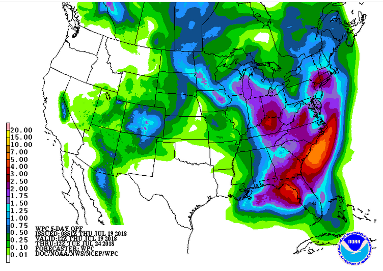
The good news is that a very wet few days are still on tap.

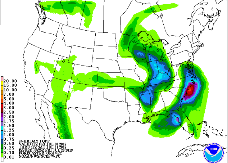
.Friday 24 hour rainfall projection.

Click for latest Base Reflectivity radar image from the Wilmington, OH radar and current weather warnings

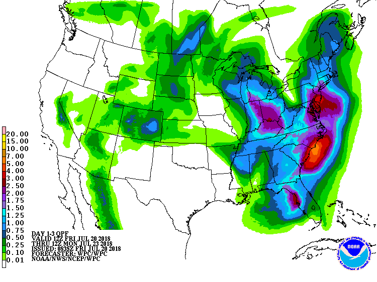
3 day rainfall projection.

Full resolution version loop (3400×1700 pixels – 2.2mb)
Central Great Lakes sector loop


Parched, Dry, Hot Conditions. Meteorological Hope And Change Appear To Be On The Horizon…I Hope!

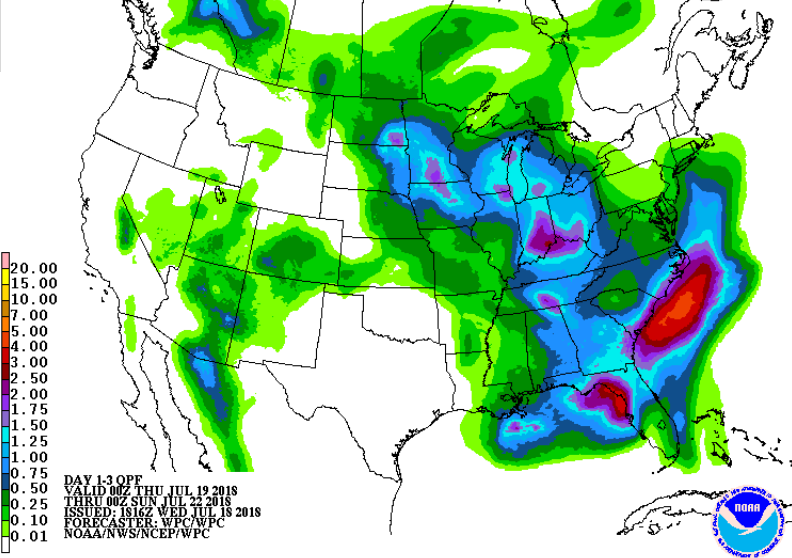
Rainfall forecast through Sunday evening

Well, I’m kind of scared to say anything given how the last few weather systems pretty well fizzled over Cincinnati and left us parched and dry but it is looking increasingly likely that Cincinnati will see widespread, substantial rainfall this weekend. I hope so.

It is getting very dry out there. I have not gotten measurable rain at my official National Weather Service Cooperative Observer site for two weeks and I have only gotten 0.59 inches in July!  I saw 5 foot tall, established oakleaf hydrangeas today, in the shade, completely wilted down. Forecast models have been consistent now for days showing a low pressure system moving into the Ohio valley Friday and then stalling for the weekend. This would result in periods of showers and thunderstorms Friday afternoon through early Monday, with chances possibly lingering into Tuesday.

Additional rainfall forecast Sunday evening through Tuesday evening

Given upper level dynamics with the stalled upper level low there will be a marginal to slight severe weather threat over Friday and over the weekend and I can’t rule out a tornado or two, especially southwest of Cincinnati.

Saturday Day 3 Severe Weather Outlook

There are also no 90’s foreseen in the 7 day forecast with below normal temperatures forecast for the next 14 days. It’s about time. For those of you who like torrid weather, the party’s over. For those of you who yearn for cooler, wetter weather, things are looking promising. Still, I am watering. I will believe it when it’s in my rain gauge.

Current 7 day rainfall projection shows 3-4 inch totals from Indianapolis southeast through Cincinnati to Maysville, KY. We’ll see…

After 3 months of brutal heat, can this be true? The 8-14 day outlook.