2 Snow Chances This Week, And Then There Were None (More Or Less)

I don’t like posting what computer models are saying a week out, especially in winter. Too little data goes into these early models so you end up with garbage in, garbage out. It leads to a lot of false hope and the impression that the weatherman doesn’t know what he is talking about. Actually, the weatherman does know what he is talking about and that is why responsible weathermen neither post early model projections without a lot of explanation nor jump on them as gospel.

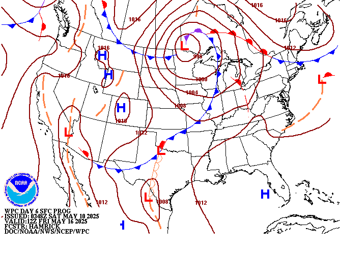
Case in point is the projection from a few days ago for a late week snowstorm. Models were pretty bullish, and they generally agreed. Several young and foolish weather guys even posted this early map of model projections.

I am posting this map here not because it is the forecast, it isn’t, but because it was an early projection by a computer and it was put out there on some weather sites. Not this one. It illustrates my point.

Newer model data for late week shows this isn’t going to happen. In fact, very little may happen. This map wasn’t a forecast. It never was. It was an early model projection drawn from insufficient data input. While forecasters did add a good chance of snow to forecasts due to model agreement, they didn’t fully bite on this. Certainly not the amounts. As new data has come in, it is apparent very little will likely happen. I can’t rule out something, but it doesn’t look real likely right now.

Another weak system was projected to bring Cincinnati a little snow today. That one looks like a dud too although a dusting can’t be ruled out.

So, two potential snows. Now, very little if any. Another chance looms for late next weekend. I’m sure if a computer model can be found projecting 20 inches some gullible teenager who is desperate for website clicks will post it. For now, just be aware we may see snow on super bowl Sunday. Maybe. Very little chance it will be 20 inches. Stay tuned.

Hurricanes Getting Stronger, Or Are They?

The in collaboration with NHC has updated the listing of the costliest tropical cyclones to strike the U.S. with a new methodology through the 2017 season. For more details see: &

At first glance, it certainly appears that hurricanes are getting more destructive and costly in recent years. However, things are not always as they seem. Let’s look at it.

50 years ago, a hurricane making landfall had a pretty good shot at coming ashore on pretty undeveloped land. As the years have progressed, explosive development has occurred on our shorelines, and cities near the coasts have also blossomed and grown into huge metropolises. Therefore, the same hurricane, hitting the same desolate coastline 50 years ago, may very well be hitting a densely populated area today. It stands to reason that damage would be much higher today, and more costly with inflation.

Additionally, many poor decisions have been made by planners. Large areas of Houston which were always meant to flood in heavy rain were opened up to development. Not all of Houston flooded during this summer’s Harvey, but those developed flood areas sure did. The same goes for New Orleans. It is below sea level, and the dysfunctional government in that city did not take care of the infrastructure. The Weather Channel broadcast a what-if scenario several years before Katrina which pretty well simulated what happened.

None of this is to say that hurricanes absolutely are not getting stronger. They may be. They may not be. It is complicated. The only thing for sure is that those who claim it is settled science cannot be trusted.

Two Snow Chances This Week In Ohio Valley

There are two chances for snow this week in Cincinnati.

A weak system could bring some bursts of snow Monday afternoon and evening with less than an inch on warm pavement and minimal impact.

A more substantial system will move in later this week with indications that more significant, even plowable, snow could occur. This early, there are many details to be worked out. Any accumulation forecasts would be foolish. The top map is the approximate location of the weather systems late wek while the bottom map is the 7 day liquid precipitation forecast. Most of the 7 day precipitation would fall in the late week storm but, as you can probably see, there is a sharp cutoff near Cincinnati. Translation: a lot could go wrong with any fanciful major snowfall forecasts.

For now, stay tuned and be advised that late week could get interesting. Maybe, No guarantees but definitely worth our attention.


Day 11 image not available

Day 9 image not available