Wednesday Evening Winter Storm Update

[7:54 PM] On Friday, we expect rain to change to a mix of freezing rain and sleet, before changing to snow. This changeover will happen at different times depending on your location. Everyone should be prepared for ice and snow accumulations Friday into Friday night.

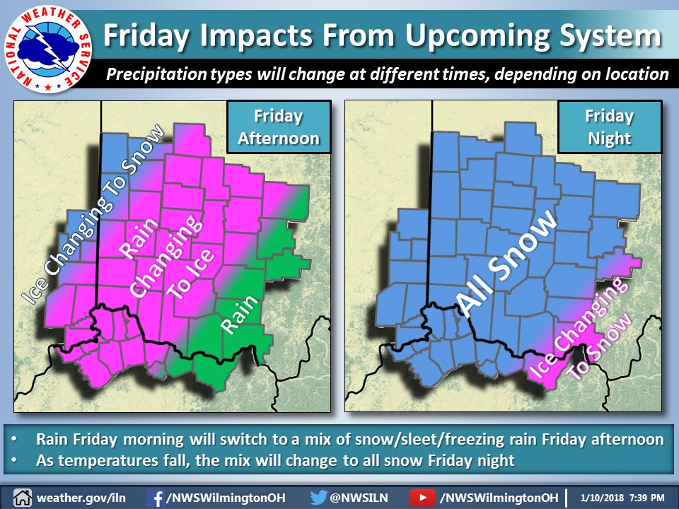
[7:55 PM] Depending on the actual track and strength of the system, some areas will see heavier accumulations than others by Friday night. Stay tuned for further updates.

——————————————

This Hazardous Weather Outlook is for East Central Indiana,
Southeast Indiana, Northern Kentucky, Central Ohio, Southwest Ohio
and West Central Ohio.

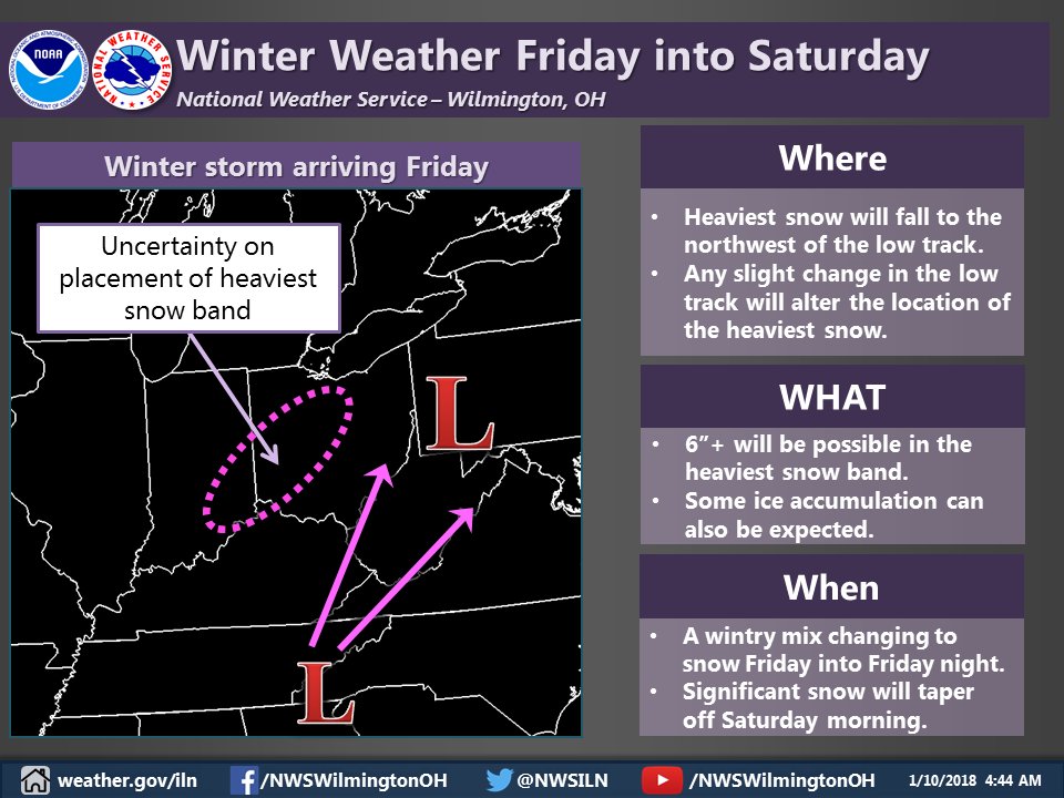
.A low pressure system is forecast to move northeast from the
Tennessee Valley to the eastern Great Lakes Friday into Saturday.
Rain is expected to transition over to a wintry mix Friday afternoon
and then gradually change over to snow Friday night. Accumulating
snow will be likely along with some ice accumulation. Any slight
track differences with this system will have large implications on
the potential weather types and impacts. This weather event will have
to be watched carefully as the week progresses.

Point Forecast:
Mack North OH
39.16°N 84.69°W (Elev. 801 ft)
Friday
Rain before 4pm, then freezing rain and sleet. High near 39. North wind 11 to 16 mph. Chance of precipitation is 100%. New ice accumulation of less than a 0.1 of an inch possible. New sleet accumulation of less than one inch possible.
Friday Night
Snow, mainly before 4am. Low around 19. North wind 13 to 17 mph, with gusts as high as 28 mph. Chance of precipitation is 100%. New snow accumulation of 2 to 4 inches possible.
Saturday
A chance of snow, mainly before noon. Cloudy, with a high near 24. Chance of precipitation is 40%. New snow accumulation of less than a half inch possible.
Saturday Night
Mostly cloudy, with a low around 9.
Sunday
Mostly sunny, with a high near 23.

Day 7 image not available

Check back to the Arbor Doctor Weather Blog for future updates.

Winter Storm Update for Cincinnati

Winter Storm Watches have been issued to the west and southwest of Cincinnati. NWS Wilmington’s confidence is not yet high enough for their forecast area. Still significant questions about snowfall rates and sleet cutting down snow amounts.

Major Storm Late Week, Impacts In Any One Place Uncertain

A major weather system is headed toward the Ohio valley for the end of the week. After a brief January thaw, heavy rain will transition to a wintry mix then snow. Many are asking how much snow. At this point, it is impossible to say. It is worth noting that it is likely this storm will be crippling for someone in the heaviest snow area. It is just impossible to say who, although Cincinnati is in play at this point. Prepare for a major winter event but remain aware that it is too early to say exactly where. Be aware that travel may become difficult or impossible in the heaviest snow area and recovery may be slow. Areas just southeast of the heaviest snow could have significant sleet or ice while areas northwest of the heaviest snow will have lighter snow and wind. Heavy rain and flooding may also be possible before the snow with over 2 inches of liquid possible. What do we currently know? See below:

Day 3 image not available


Day 8 image not available

Here is our latest thinking on the potential for winter weather Friday into Saturday.