High Impact Storm Late This Week

Details To Be Worked Out…

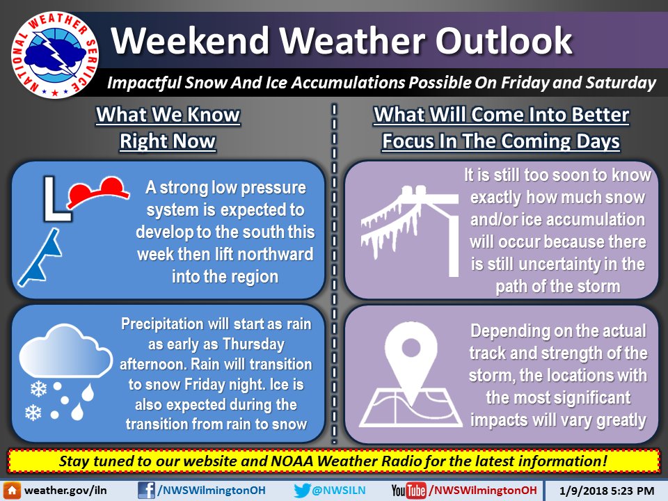
[4:38 PM] Impactful snow and ice accumulations are possible for Friday and Saturday as a strong low pressure system will move through the Ohio Valley. Here is what we know right now and what we are keeping a close eye on:

Hazardous Weather Outlook
National Weather Service Wilmington OH
259 PM EST Tue Jan 9 2018

INZ066-073>075-080-KYZ089>100-OHZ045-046-052>056-062>065-070>074-
077>082-088-101200-
Franklin IN-Ripley-Dearborn-Ohio-Switzerland-Carroll-Gallatin-Boone-
Kenton-Campbell-Owen-Grant-Pendleton-Bracken-Robertson-Mason-Lewis-
Union OH-Delaware-Champaign-Clark-Madison-Franklin OH-Licking-Greene-
Fayette OH-Pickaway-Fairfield-Butler-Warren-Clinton-Ross-Hocking-
Hamilton-Clermont-Brown-Highland-Adams-Pike-Scioto-
259 PM EST Tue Jan 9 2018

This Hazardous Weather Outlook is for Southeast Indiana, Northeast
Kentucky, Northern Kentucky, Central Ohio, Southwest Ohio and West
Central Ohio.


A low pressure system is forecast to move northeast from the
Tennessee Valley to the eastern Great Lakes Friday into Saturday.
Rain is expected to transition over to a wintry mix Friday afternoon
and then gradually changeover to snow Friday night. Accumulating
snow and ice will be possible with this system. Any slight track
differences with this system will have large implications on the
potential weather types and impacts. This weather event will have to
be watched carefully as the week progresses.

Day 1 image not available

Day 2 image not available

Day 8 image not available


Cold then warm then…

As we look forward to warmer temps this week, Dayton (4.1 Fahrenheit) and Cincinnati (8.5F) had their coldest Jan 1-6 on record while Columbus (7.9) had its 2nd coldest Jan 1-6 on record.

Temperatures could peak near 60 by the middle of this week but don’t get too used to it.

A strong storm system will organize for late in the week then move east. It will begin

Day 3 image not availableas rain in Cincinnati on Friday and then things get interesting. It looks likely that this storm will turn into a big and nasty winter storm with severe storms over the south and heavy snow or even a blizzard to the northwest of the center. The $64,000 question is where will the storm track? It is too early to tell. However, significant impacts are possible in Cincinnati at this point.

Day 4 image not available

Stay tuned.

After a few days of more bitter cold next weekend, it should again turn warmer for a week or two before winter sets in again for February. Winter is in gear. It may go away for a bit but there is lot more winter to come and this weekend could be one installment.

8 to 14 Day Outlooks
Valid: January 15 2018 to January 21 2018
Updated: 07 Jan 2018
Click below for information about how to read 8-14 day outlook maps
Temperature        Precipitation

Temperature

8 to 14 Day Outlook - Temperature Probability

Precipitation

8 to 14 Day Outlook - Precipitation Probability

WINTER WEATHER ADVISORY IN EFFECT FROM MIDNIGHT TONIGHT TO 2 PM EST MONDAY FOR CINCINNATI TRI-STATE

A big concern is the very cold pavement temperatures after 2 weeks below freezing and several mornings below zero. Rain may freeze on cold pavement even if air temperature is a couple degrees above freezing. The pavement surface sensor below at I-275 and Kilby is currently 12.2 degrees F.


  • Avg Wind Speed: 0.6 mph
  • Max Wind Speed: 1.9 mph
  • Wind Direction: South
  • Precip Rate: 0 iph


  • Surface Sensor: IR275 NB Driving (0)
  • Last Updated: 1/7/2018 7:10:00 AM
  • Surface Status: Dry
  • Surface Temp: 12.2 °F


  • Surface Sensor: IR275 SB Driving (1)
  • Last Updated: 1/7/2018 7:10:00 AM
  • Surface Status: Dry


Day 1 image not available

URGENT - WINTER WEATHER MESSAGE
National Weather Service Wilmington OH
357 AM EST Sun Jan 7 2018

INZ073>075-080-KYZ089>100-OHZ073-074-077>082-088-071700-
/O.NEW.KILN.WW.Y.0001.180108T0500Z-180108T1900Z/
Ripley-Dearborn-Ohio-Switzerland-Carroll-Gallatin-Boone-Kenton-
Campbell-Owen-Grant-Pendleton-Bracken-Robertson-Mason-Lewis-Ross-
Hocking-Hamilton-Clermont-Brown-Highland-Adams-Pike-Scioto-
Including the cities of Batesville, Milan, Versailles,
Lawrenceburg, Aurora, Rising Sun, Vevay, Carrollton, Warsaw,
Florence, Burlington, Oakbrook, Covington, Erlanger,
Independence, Newport, Alexandria, Owenton, Williamstown,
Crittenden, Dry Ridge, Falmouth, Butler, Augusta, Brooksville,
Mount Olivet, Maysville, Vanceburg, Tollesboro, Chillicothe,
Logan, Cincinnati, Milford, Georgetown, Mount Orab, Hillsboro,
Greenfield, West Union, Peebles, Waverly, Piketon, Portsmouth,
and Wheelersburg
357 AM EST Sun Jan 7 2018

...WINTER WEATHER ADVISORY IN EFFECT FROM MIDNIGHT TONIGHT TO
2 PM EST MONDAY...

* WHAT...Mixed precipitation expected. The ice will result in
  difficult travel conditions, including during the morning
  commute on Monday. Total ice accumulations of around one tenth
  of an inch are expected. Little if any snow accumulation is
  expected.

* WHERE...Portions of Southeast Indiana, Northeast and Northern
  Kentucky and Central and Southwest Ohio.

* WHEN...From midnight tonight to 2 PM EST Monday.

PRECAUTIONARY/PREPAREDNESS ACTIONS...

A Winter Weather Advisory means that periods of snow, sleet or
freezing rain will cause travel difficulties. Be prepared for
slippery roads and limited visibilities, and use caution while
driving. Additional information can be found at
www.weather.gov/iln as well as on our Facebook and Twitter pages.