[4:05 PM] We may have sunny skies right now, but a mix of rain and freezing rain will overspread the area late tonight. Greatest threat for ice accumulation will be in parts of Miami Valley and central Ohio. Little to no ice south of OH River. Exercise caution late tonight!
URGENT - WINTER WEATHER MESSAGE
National Weather Service Wilmington OH
235 PM EDT Fri Mar 16 2018

INZ050-058-059-066-OHZ026-060-070>072-077>082-088-170245-
/O.EXB.KILN.WW.Y.0013.180317T0400Z-180317T1600Z/
Wayne-Fayette IN-Union IN-Franklin IN-Hardin-Preble-Butler-Warren-
Clinton-Hamilton-Clermont-Brown-Highland-Adams-Pike-Scioto-
Including the cities of Richmond, Connersville, Liberty,
West College Corner, Brookville, Kenton, Ada, Eaton, Camden,
Hamilton, Middletown, Fairfield, Oxford, Mason, Lebanon,
Springboro, Wilmington, Blanchester, Cincinnati, Milford,
Georgetown, Mount Orab, Hillsboro, Greenfield, West Union,
Peebles, Waverly, Piketon, Portsmouth, and Wheelersburg
235 PM EDT Fri Mar 16 2018

...WINTER WEATHER ADVISORY IN EFFECT FROM MIDNIGHT TONIGHT TO
NOON EDT SATURDAY...

* WHAT...Mixed precipitation expected. Total ice accumulations of
  up to a tenth of an inch are expected.

* WHERE...Portions of East Central and Southeast Indiana and
  South Central, Southwest and West Central Ohio.

* WHEN...From midnight tonight to noon EDT Saturday.

* ADDITIONAL DETAILS...The ice will result in difficult travel
  conditions. Be prepared for slippery roads early Saturday
  morning.

PRECAUTIONARY/PREPAREDNESS ACTIONS...

A Winter Weather Advisory means that periods of snow, sleet or
freezing rain will cause travel difficulties. Be prepared for
slippery roads and limited visibilities, and use caution while
driving. Additional information can be found at
www.weather.gov/iln as well as on our Facebook and Twitter pages.
Station Number: OH-HM-24
Station Name: Cheviot 3.4 W
Report Date: 2/25/2018
Submitted: 2/25/2018 7:33 AM
Scale Bar: Severely Wet
Description:
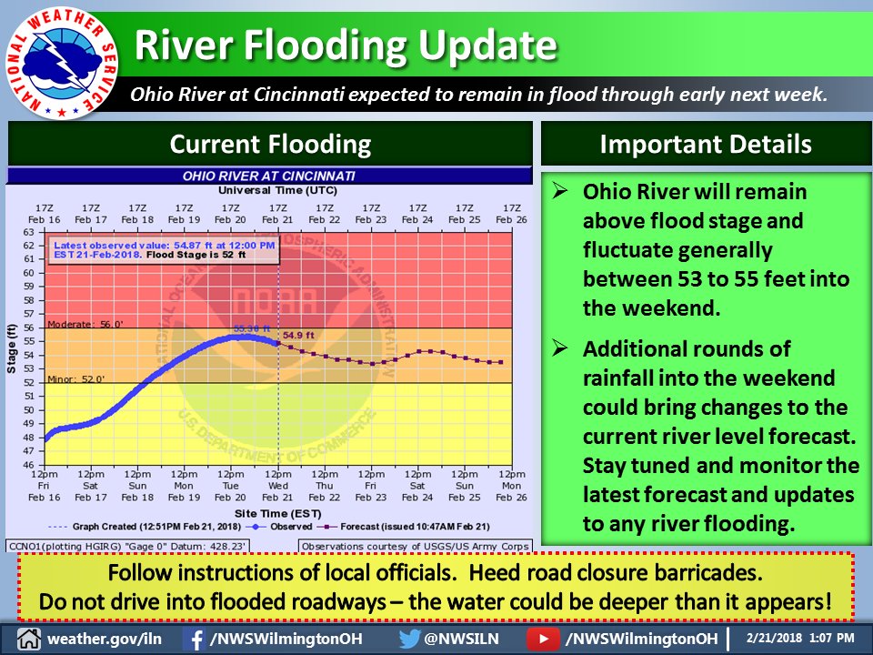
3 day storm total ending this morning 4.16 inches. 7 day rainfall 5.54 inches. February total to date: 8.24. Most area rivers and streams in flood. Widespread flooding and flash flooding last night and this morning. Water rescues reported. Worst Ohio River flooding since 1997. Many agricultural fields are under water. Businesses and homes are flooded near rivers and streams. Many roads closed. Disaster declarations from the Ohio governor for a number of counties.
Categories: General Awareness
Agriculture
Business & Industry
Plants & Wildlife
Relief, Response & Restrictions
Society & Public Health
Water Supply & Quality
What is the Condition Monitoring Report? Click here for more information:
The National Weather Service in Wilmington has issued a
* Flood Watch for portions of Southeast Indiana, Northern
Kentucky, and Southwest Ohio, including the following areas,
in Southeast Indiana, Dearborn, Franklin IN, Ohio, Ripley, and
Switzerland. In Northern Kentucky, Boone, Bracken, Campbell,
Carroll, Gallatin, Grant, Kenton, Owen, Pendleton, and
Robertson. In Southwest Ohio, Butler, Clermont, Hamilton, and
Warren.
* From 7 PM EST this evening through Sunday morning.
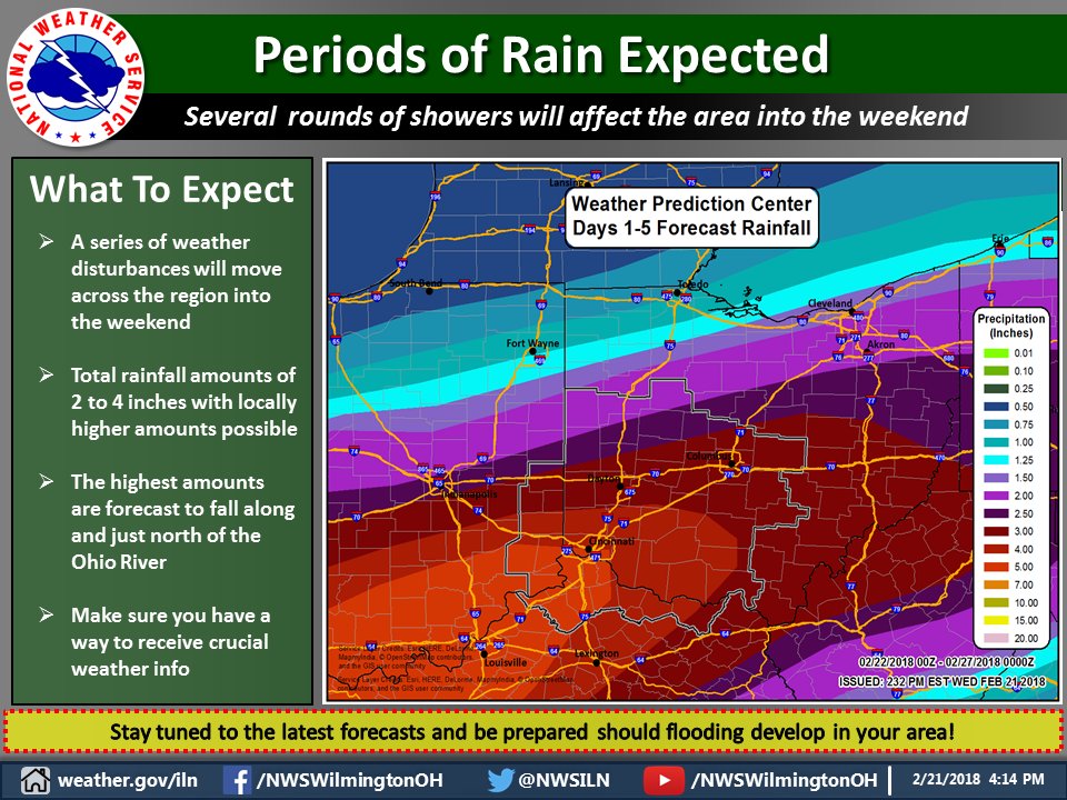
* Precipitation will move across the area starting this evening
and then taper off Thursday afternoon. Additional rounds of
precipitation will then move across the region through Sunday
morning. Total rainfall amounts through Sunday morning are
expected to be in the two to four inch range.
* Excessive rainfall will cause local rivers, creeks, and streams
to rise. Those near streams and rivers should be especially
cautious as streams and rivers can rise quickly.
PRECAUTIONARY/PREPAREDNESS ACTIONS...
People in the watch area, especially those living in areas prone
to flooding, should be prepared to take action should flooding
develop. Monitor the latest forecasts and be alert for possible
flood warnings.
Flood Watch
National Weather Service Wilmington OH
249 PM EST Wed Feb 21 2018

...MULTIPLE ROUNDS OF HEAVY RAINFALL EXPECTED THROUGH THE FIRST
HALF OF THE WEEKEND...

INZ066-073>075-080-KYZ089>098-OHZ070-071-077-078-221200-
/O.NEW.KILN.FA.A.0003.180222T0000Z-180225T1500Z/
/00000.0.ER.000000T0000Z.000000T0000Z.000000T0000Z.OO/
Franklin IN-Ripley-Dearborn-Ohio-Switzerland-Carroll-Gallatin-
Boone-Kenton-Campbell-Owen-Grant-Pendleton-Bracken-Robertson-
Butler-Warren-Hamilton-Clermont-
Including the cities of Brookville, Batesville, Milan,
Versailles, Lawrenceburg, Aurora, Rising Sun, Vevay, Carrollton,
Warsaw, Florence, Burlington, Oakbrook, Covington, Erlanger,
Independence, Newport, Alexandria, Owenton, Williamstown,
Crittenden, Dry Ridge, Falmouth, Butler, Augusta, Brooksville,
Mount Olivet, Hamilton, Middletown, Fairfield, Oxford, Mason,
Lebanon, Springboro, Cincinnati, and Milford
249 PM EST Wed Feb 21 2018

...FLOOD WATCH IN EFFECT FROM 7 PM EST THIS EVENING THROUGH
SUNDAY MORNING...

The National Weather Service in Wilmington has issued a

* Flood Watch for portions of Southeast Indiana, Northern
  Kentucky, and Southwest Ohio, including the following areas,
  in Southeast Indiana, Dearborn, Franklin IN, Ohio, Ripley, and
  Switzerland. In Northern Kentucky, Boone, Bracken, Campbell,
  Carroll, Gallatin, Grant, Kenton, Owen, Pendleton, and
  Robertson. In Southwest Ohio, Butler, Clermont, Hamilton, and
  Warren.

* From 7 PM EST this evening through Sunday morning.

* Precipitation will move across the area starting this evening
  and then taper off Thursday afternoon. Additional rounds of
  precipitation will then move across the region through Sunday
  morning. Total rainfall amounts through Sunday morning are
  expected to be in the two to four inch range.

* Excessive rainfall will cause local rivers, creeks, and streams
  to rise. Those near streams and rivers should be especially
  cautious as streams and rivers can rise quickly.

PRECAUTIONARY/PREPAREDNESS ACTIONS...

People in the watch area, especially those living in areas prone
to flooding, should be prepared to take action should flooding
develop. Monitor the latest forecasts and be alert for possible
flood warnings.
URGENT - WINTER WEATHER MESSAGE
National Weather Service Wilmington OH
252 PM EST Wed Feb 21 2018

OHZ026-034-035-042>046-052-221200-
/O.NEW.KILN.WW.Y.0010.180222T0600Z-180222T1600Z/
Hardin-Mercer-Auglaize-Darke-Shelby-Logan-Union OH-Delaware-
Champaign-
Including the cities of Kenton, Ada, Celina, Coldwater,
Wapakoneta, St. Marys, Greenville, Sidney, Bellefontaine,
Marysville, Delaware, and Urbana
252 PM EST Wed Feb 21 2018

...WINTER WEATHER ADVISORY IN EFFECT FROM 1 AM TO 11 AM EST
THURSDAY...

* WHAT...Freezing rain expected. Total ice accumulations of up
  to one tenth of an inch are expected.

* WHERE...Portions of Central and West Central Ohio.

* WHEN...From 1 AM to 11 AM EST Thursday.

* ADDITIONAL DETAILS...Plan on slippery road conditions. Be
  prepared for reduced visibilities at times.

PRECAUTIONARY/PREPAREDNESS ACTIONS...

A Winter Weather Advisory means that periods of freezing rain
will cause travel difficulties. Be prepared for slippery roads.
Slow down and use caution while driving. Additional information
can be found at www.weather.gov/iln as well as on our Facebook
and Twitter pages.


 The National Weather Service in Wilmington has issued a
* Flood Watch for portions of Southeast Indiana, Northern
Kentucky, and Southwest Ohio, including the following areas,
in Southeast Indiana, Dearborn, Franklin IN, Ohio, Ripley, and
Switzerland. In Northern Kentucky, Boone, Bracken, Campbell,
Carroll, Gallatin, Grant, Kenton, Owen, Pendleton, and
Robertson. In Southwest Ohio, Butler, Clermont, Hamilton, and
Warren.
* From 7 PM EST this evening through Sunday morning.
* Precipitation will move across the area starting this evening
and then taper off Thursday afternoon. Additional rounds of
precipitation will then move across the region through Sunday
morning. Total rainfall amounts through Sunday morning are
expected to be in the two to four inch range.
* Excessive rainfall will cause local rivers, creeks, and streams
to rise. Those near streams and rivers should be especially
cautious as streams and rivers can rise quickly.
PRECAUTIONARY/PREPAREDNESS ACTIONS...
People in the watch area, especially those living in areas prone
to flooding, should be prepared to take action should flooding
develop. Monitor the latest forecasts and be alert for possible
flood warnings.
The National Weather Service in Wilmington has issued a
* Flood Watch for portions of Southeast Indiana, Northern
Kentucky, and Southwest Ohio, including the following areas,
in Southeast Indiana, Dearborn, Franklin IN, Ohio, Ripley, and
Switzerland. In Northern Kentucky, Boone, Bracken, Campbell,
Carroll, Gallatin, Grant, Kenton, Owen, Pendleton, and
Robertson. In Southwest Ohio, Butler, Clermont, Hamilton, and
Warren.
* From 7 PM EST this evening through Sunday morning.
* Precipitation will move across the area starting this evening
and then taper off Thursday afternoon. Additional rounds of
precipitation will then move across the region through Sunday
morning. Total rainfall amounts through Sunday morning are
expected to be in the two to four inch range.
* Excessive rainfall will cause local rivers, creeks, and streams
to rise. Those near streams and rivers should be especially
cautious as streams and rivers can rise quickly.
PRECAUTIONARY/PREPAREDNESS ACTIONS...
People in the watch area, especially those living in areas prone
to flooding, should be prepared to take action should flooding
develop. Monitor the latest forecasts and be alert for possible
flood warnings.