A summer heat wave is expanding over the central US and will be spreading eastward:

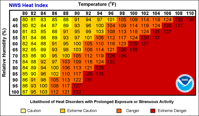
Heat indices in excess of 100, and in some cases 115, will be becoming increasingly prevalent:
It doesn’t look like a significant break in the heat is likely anytime soon. The 8-14 day outlook calls for above normal temperatures over a wide area, and July is the hottest month of the year anyway, the peak of meteorological summer:

The week 3 and 4 outlook shows the heat may shift west some, and relax a bit in the east:

However, the overall July outlook is hot:

With all the heat, rainfall may be a bit sparse in many areas:


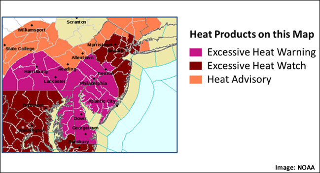
Each National Weather Service Forecast Office issues some or all of the following heat-related products as conditions warrant. NWS local offices often collaborate with local partners to determine when an alert should be issued for a local area. For instance, residents of Florida are much more prepared for 90°F+ weather than residents in Alaska.
- Excessive Heat Warning—Take Action! An Excessive Heat Warning is issued within 12 hours of the onset of extremely dangerous heat conditions. The general rule of thumb for this Warning is when the maximum heat index temperature is expected to be 105° or higher for at least 2 days and night time air temperatures will not drop below 75°; however, these criteria vary across the country, especially for areas not used to extreme heat conditions. If you don’t take precautions immediately when conditions are extreme, you may become seriously ill or even die.
- Excessive Heat Watches—Be Prepared! Heat watches are issued when conditions are favorable for an excessive heat event in the next 24 to 72 hours. A Watch is used when the risk of a heat wave has increased but its occurrence and timing is still uncertain.
- Heat Advisory—Take Action! A Heat Advisory is issued within 12 hours of the onset of extremely dangerous heat conditions. The general rule of thumb for this Advisory is when the maximum heat index temperature is expected to be 100° or higher for at least 2 days, and night time air temperatures will not drop below 75°; however, these criteria vary across the country, especially for areas that are not used to dangerous heat conditions. Take precautions to avoid heat illness. If you don’t take precautions, you may become seriously ill or even die.
- Excessive Heat Outlooks are issued when the potential exists for an excessive heat event in the next 3-7 days. An Outlook provides information to those who need considerable lead-time to prepare for the event.
Stay Informed: Monitor local radio and television (including NOAA Weather Radio), internet and social media for information and updates.