Soil Moisture Condition Monitoring Weekly Report: Mildly Dry

Station Number: OH-HM-24
Station Name: Cheviot 3.4 W
Report Date: 7/28/2018
Submitted: 7/28/2018 6:24 AM
Scale Bar: Mildly Dry
Description:
 
0.39 inches of rain in the past week and 2.07 inches for July. Most of that total has fallen in the past 2 weeks so while some mild drought stress is still evident in lawns and landscapes most plants are green and doing pretty good. Ground is dry and we could definitely use more rain.
 
Categories: General Awareness
Agriculture
Plants & Wildlife

This report is specifically for the Arbor Doctor’s location 3.4 miles west of Cheviot, OH, in the western suburbs of Cincinnati in southwest Ohio. This location is also an official cooperative observation site for the National Weather Service listed as Cheviot 3W.

What is the Condition Monitoring Report? See these links for more information:

Explanation of scale bar>>>

Search condition monitoring reports for the entire US>>>

Soil Moisture Condition Monitoring Weekly Report: Mildly Dry

Station Number: OH-HM-24
Station Name: Cheviot 3.4 W
Report Date: 7/21/2018
Submitted: 7/21/2018 6:39 AM
Scale Bar: Mildly Dry
Description:
 
Only 0.59 inches of rain in the first 19 days of July. Significant drought stress was developing and we had moved into the Moderately Dry category by the 19th. 1.09 inches in the past 36 hours in multiple rounds of showers and thunderstorms allowing for good percolation. Temperatures much cooler with all the rain. Grass and plants re-greening remarkably. More rain on the way.
 
Categories: General Awareness
Agriculture
Plants & Wildlife

This report is specifically for the Arbor Doctor’s location 3.4 miles west of Cheviot, OH, in the western suburbs of Cincinnati in southwest Ohio. This location is also an official cooperative observation site for the National Weather Service listed as Cheviot 3W.

What is the Condition Monitoring Report? See these links for more information:

Explanation of scale bar>>>

Search condition monitoring reports for the entire US>>>

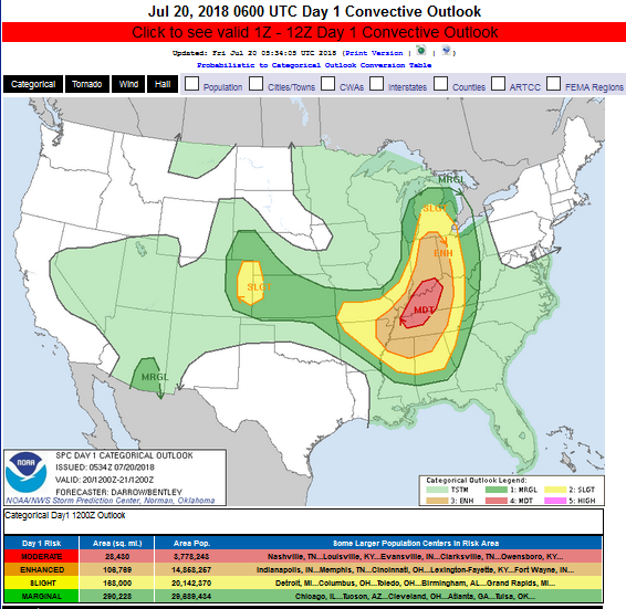
SIGNIFICANT SEVERE STORM AND TORNADO RISK THIS AFTERNOON. WET WEEKEND ON TAP. PAY ATTENTION. SAME SYSTEM THAT RAKED IOWA YESTERDAY AND IT IS NOT CALMING DOWN

Day 1 Convective Outlook
NWS Storm Prediction Center Norman OK
1234 AM CDT Fri Jul 20 2018

Valid 201200Z – 211200Z

…THERE IS A MODERATE RISK OF SEVERE THUNDERSTORMS FROM WESTERN TN TO SOUTHERN IN…

…THERE IS A SLIGHT RISK OF SEVERE THUNDERSTORMS FROM LOWER MI TO MS AND AL…

…SUMMARY…
Severe thunderstorms will develop across the Ohio and Tennessee
Valley region into the Mid-South Friday. Very large hail, damaging
winds, and a few tornadoes can be expected. Isolated severe storms
are possible across the central High Plains.

Hazardous Weather Outlook National Weather Service Wilmington OH 404 AM EDT Fri Jul 20 2018

Wayne-Fayette IN-Union IN-Franklin IN-Ripley-Dearborn-Ohio- Switzerland-Carroll-Gallatin-Boone-Kenton-Campbell-Owen-Grant- Pendleton-Bracken-Robertson-Mason-Lewis-Hardin-Mercer-Auglaize-Darke- Shelby-Logan-Union OH-Miami-Champaign-Clark-Madison-Preble- Montgomery-Greene-Fayette OH-Butler-Warren-Clinton-Hamilton-Clermont- Brown-Highland-Adams- 404 AM EDT Fri Jul 20 2018

This Hazardous Weather Outlook is for East Central Indiana, Southeast Indiana, Northeast Kentucky, Northern Kentucky, Central Ohio, South Central Ohio, Southwest Ohio and West Central Ohio. .

DAY ONE…Today and Tonight. Showers and thunderstorms are expected to develop today, with the greatest potential for storms during the afternoon and evening. Some severe storms are expected, with a threat for large hail, damaging winds, tornadoes, and heavy rainfall.

The good news is that a very wet few days are still on tap.
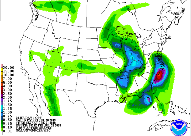
.Friday 24 hour rainfall projection.
Click for latest Base Reflectivity radar image from the Wilmington, OH radar and current weather warnings

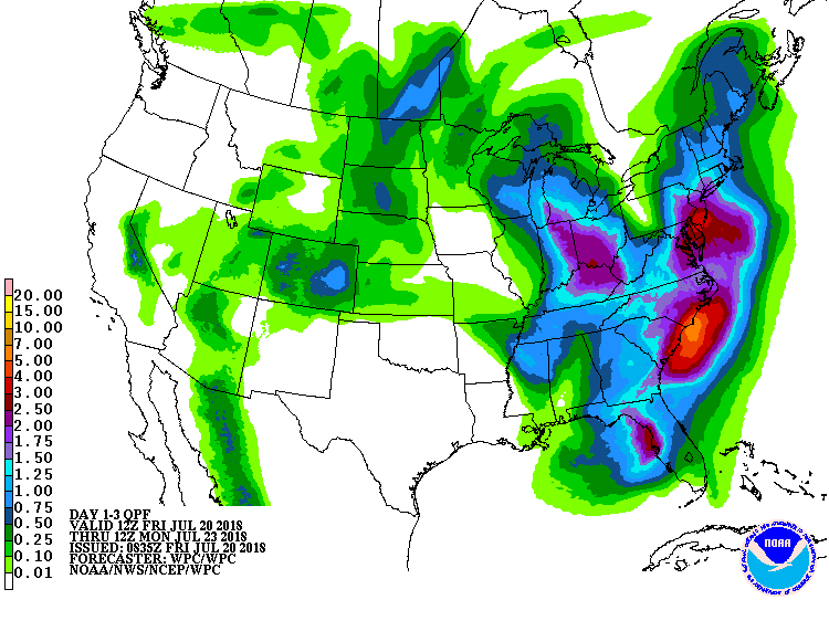
3 day rainfall projection.

Full resolution version loop (3400×1700 pixels – 2.2mb)
Central Great Lakes sector loop