Soil Moisture Condition Monitoring Weekly Report: Severely Wet

Station Number: OH-HM-24
Station Name: Cheviot 3.4 W
Report Date: 3/9/2019
Submitted: 3/09/2019 6:43 AM
Scale Bar: Severely Wet

Description:
0.29 of rain and melted snow in the past week. Ground is completely saturated with water. Standing water remains in low areas and ditches and in recently flooded fields.


Categories:
General Awareness
Agriculture
Plants & Wildlife

This report is specifically for the Arbor Doctor’s location 3.4 miles west of Cheviot, OH, in the western suburbs of Cincinnati in southwest Ohio. This location is also an official cooperative observation site for the National Weather Service listed as Cheviot 3W.

What is the Condition Monitoring Report? See these links for more information:

Explanation of scale bar>>>

Search condition monitoring reports for the entire US>>>

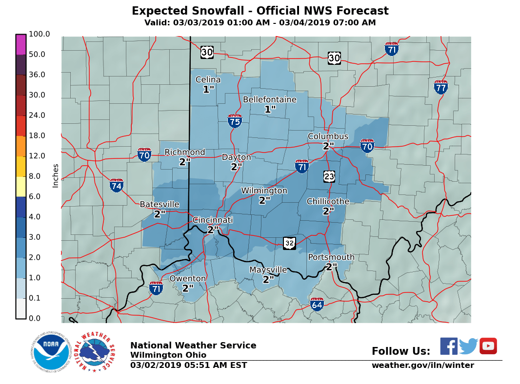
Sunday’s snow is looking much less impressive in Cincinnati. Cold still on the way.

The Sunday storm system is much less impressive than it appeared a few days ago.

When I was presented with the rumors earlier in the week that Sunday’s snow would amount to 4-8 inches, I expressed great skepticism. The storm was still out over the Pacific Ocean and was poorly sampled at that point. However, all computer models seemed to agree on a potent winter storm targeting the Ohio valley and even the National Weather Service was headlining the storm.

Once the storm came ashore and was better sampled, the storm intensity in computer projections began to decline.  That trend has continued through this morning. 1-3 inches is still expected, but even that is still a tad sketchy. Why?

Pavement temperatures are very warm and the METRo road model is  suggesting road surface temps will make it into the low to mid 40s Sunday afternoon. The sun is very warm this time of year. Even on a cloudy day, some of the sun’s radiation still makes it to the ground.  Accumulation of snow tends to be inefficient during daylight hours with a high sun angle.

Sunday’s system has trended well to the south with the best moisture well south of the Ohio River. This decreases the chances of rain mixing in but temperatures will still be marginal. Snow may accumulate better on grass than on pavement, and there is still a chance some spots could get more than 3 inches of snow, but at this point it looks like most of the area will see a relatively low impact snow event.

For churchgoers, Sunday morning snow appears light with fairly minimal accumulations on pavement. Stay tuned to updates. Things could still change a bit, but right now Sunday’s storm just does not look like a major storm. It will get much colder for a few days, starting Sunday night.

Soil Moisture Condition Monitoring Weekly Report: Severely Wet

Station Number: OH-HM-24
Station Name: Cheviot 3.4 W
Report Date: 3/2/2019
Submitted: 3/02/2019 6:30 AM
Scale Bar: Severely Wet
Description:
 
Only 0.38 inches of rain in the past week but nearly 8 inches of liquid precipitation in February and over 13 inches of liquid in 2019, over 6 inches above normal. Ground is completely saturated with water. Standing water is severe and abundant. Water bodies are very elevated.
 
Categories:
General Awareness
Agriculture
Plants & Wildlife

This report is specifically for the Arbor Doctor’s location 3.4 miles west of Cheviot, OH, in the western suburbs of Cincinnati in southwest Ohio. This location is also an official cooperative observation site for the National Weather Service listed as Cheviot 3W.

What is the Condition Monitoring Report? See these links for more information:

Explanation of scale bar>>>

Search condition monitoring reports for the entire US>>>