Summertime, and the living is hot! Meteorological summer, which encompasses June, July, and August, is looking quite hot this year, with an active tropical season. Once again this year, the heat may last into fall.

After a beautiful, cool last weekend of meteorological spring, June 1 marks the first day of meteorological, climatological, and horticultural summer, and the weather will show it this year.

The traditional kickoff to summer is Memorial Day weekend and the traditional ending to summer is Labor Day weekend. This does not match up well with the calendar, but it does match up well with climatology and nature.

Spring: March 1-May 31; Summer: June 1-August 31; Fall: September 1-November 30; Winter: December 1-February 28 (29)

You may have noticed that Arbor Doctor, meteorologists and climatologists define seasons differently from “regular” or astronomical spring, summer, fall, and winter. So, why do  meteorological and astronomical seasons begin and end at different times? Read more here>>>

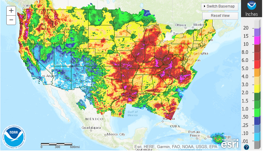
The weather pattern is already looking summer-like. We have had 2 named tropical storms in the Atlantic before the official June 1 start to hurricane season. Another tropical storm appears likely to form in the Gulf of Mexico later this week then turn northward, perhaps stalling near the gulf coast and causing one of those multi-day flooding events down there.

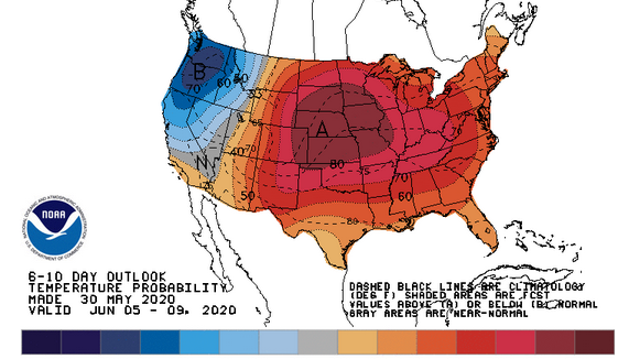
The polar jet stream, which pushed the cool air south this weekend and brought a late frost to parts of the Great Lakes and northern plains, is retreating northward. In its wake, hot air will build this week in the center of the country then build eastward. Cincinnati will move back into a summertime pattern this week with heat, humidity, and daily thunderstorm chances returning by mid-week.

Meteorological summer, which encompasses June, July, and August, is looking quite hot this year, with an active tropical season. Once again this year, the heat may last into fall.


Soil Moisture Condition Monitoring Weekly Report: Severely Wet

30 day rainfall:

United States Drought Monitor

Station Number: OH-HM-24
Station Name: Cheviot 3.4 W
Report Date: 5/30/2020
Submitted: 5/30/2020 6:19 AM
Scale Bar: Severely Wet
Description:

2.14 inches of rain in the past week and 7.45 inches of rain in May. Soil is completely saturated. Standing water in swales and runoff coming off hillsides.

Categories:

General Awareness
Agriculture
Plants & Wildlife

Frozen. What you are seeing is likely the result of 2 severe late freezes which have impacted many of our trees and landscape plants. May 17, 2020

This report is specifically for the Arbor Doctor’s location 3.4 miles west of Cheviot, OH, in the western suburbs of Cincinnati in southwest Ohio. This location is also an official cooperative observation site for the National Weather Service listed as Cheviot 3W.

What is the Condition Monitoring Report? See these links for more information:

Explanation of scale bar>>>

Search condition monitoring reports for the entire US>>>  

CoCoRaHS Condition Monitoring Report Map>>> 

Please remember to water…correctly!

Water once per week, one inch per week, under the entire branch spread, in the absence of rain, May through November. Either rainfall or your watering should equal the one inch per week. Put out a sprinkler and a straight sided soup can or rain gauge and measure one inch per week.

11-inch capacity rain gauge  

Taylor rain gauge   

Watering: How and when>>>

Watering Trees and Shrubs>>>


Soil Moisture Index:

Meteorological Versus Astronomical Seasons. Spring is here!

Spring: March 1-May 31; Summer: June 1-August 31; Fall: September 1-November 30; Winter: December 1-February 28 (29)

You may have noticed that Arbor Doctor, meteorologists and climatologists define seasons differently from “regular” or astronomical spring, summer, fall, and winter. So, why do  meteorological and astronomical seasons begin and end at different times? Read more here>>>

Spring leaf out (click on map to enlarge):

Comparison of 2020 spring leaf out to average from 1981-2010

Spring bloom index (Click on map to enlarge):

Comparison of 2020 spring bloom to average from 1981-2010

Soil Moisture Condition Monitoring Weekly Report: Severely Wet

United States Drought Monitor

Station Number: OH-HM-24
Station Name: Cheviot 3.4 W
Report Date: 5/23/2020
Submitted: 5/23/2020 6:31 AM
Scale Bar: Severely Wet
Description:

3.37 inches of rain in the past week here but totals of 3-6 inches in the metro area over the past week. Soil is completely saturated with standing water in swale areas. Area waterways are beginning to recede but many flooded or rose into the action stage.

Categories: General Awareness
Agriculture
Business & Industry
Plants & Wildlife

Frozen. What you are seeing is likely the result of 2 severe late freezes which have impacted many of our trees and landscape plants. May 17, 2020

This report is specifically for the Arbor Doctor’s location 3.4 miles west of Cheviot, OH, in the western suburbs of Cincinnati in southwest Ohio. This location is also an official cooperative observation site for the National Weather Service listed as Cheviot 3W.

What is the Condition Monitoring Report? See these links for more information:

Explanation of scale bar>>>

Search condition monitoring reports for the entire US>>>  

CoCoRaHS Condition Monitoring Report Map>>> 


Soil Moisture Index:

Meteorological Versus Astronomical Seasons. Spring is here!

Spring: March 1-May 31; Summer: June 1-August 31; Fall: September 1-November 30; Winter: December 1-February 28 (29)

You may have noticed that Arbor Doctor, meteorologists and climatologists define seasons differently from “regular” or astronomical spring, summer, fall, and winter. So, why do  meteorological and astronomical seasons begin and end at different times? Read more here>>>

 Spring leaf out (click on map to enlarge):

Comparison of 2020 spring leaf out to average from 1981-2010

Spring bloom index (Click on map to enlarge):

Comparison of 2020 spring bloom to average from 1981-2010