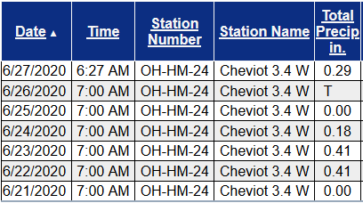
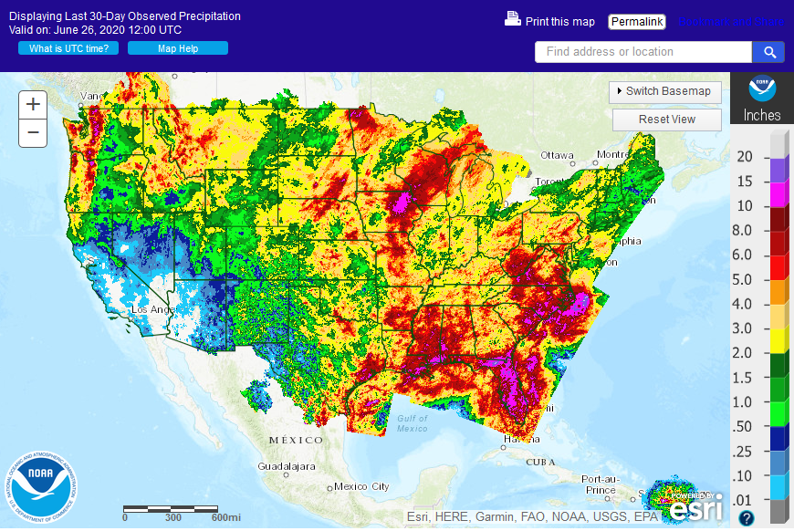
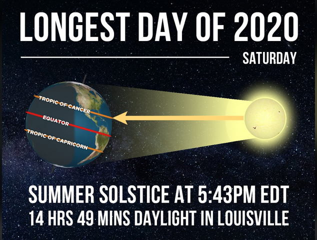
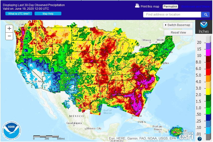
Hot weather will be moving eastward toward the end of the week, bringing a toasty end of the week and weekend to the Ohio valley as we move deeper into meteorological summer and near the beginning of astronomical summer. Conditions have also become quite dry in the Cincinnati area.
Please remember to water…correctly!
Water once per week, one inch per week, under the entire branch spread, in the absence of rain, May through November. Either rainfall or your watering should equal the one inch per week. Put out a sprinkler and a straight sided soup can or rain gauge and measure one inch per week.
11-inch capacity rain gauge 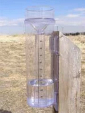
Taylor rain gauge 
Meanwhile, winter storm watches are in effect for the northern Rockies of Montana and Idaho.

Winter Storm Watch
URGENT – WINTER WEATHER MESSAGE
National Weather Service Great Falls MT
304 AM MDT Tue Jun 16 2020
MTZ008-015-052-055-162200-
/O.CON.KTFX.WS.A.0007.200617T0000Z-200617T1800Z/
Beaverhead-Madison-Jefferson-Gallatin-
Including Big Hole Pass, Wisdom, Monida Pass, Raynolds Pass,
Virginia City, Elk Park Pass, Homestake Pass, West Yellowstone,
Battle Ridge Pass, and Targhee Pass
304 AM MDT Tue Jun 16 2020
…WINTER STORM WATCH REMAINS IN EFFECT FROM THIS EVENING THROUGH
WEDNESDAY MORNING ABOVE 6000 FEET…
* WHAT…Heavy snow possible above 6000 feet. Total snow
accumulations of up to 8 inches. Locally higher amounts
exceeding 12 inches are possible above 7500 feet.
* WHERE…Elevations above 6000 feet in Beaverhead, Madison,
Jefferson, and Gallatin Counties.
* WHEN…From Tuesday evening through Wednesday morning.
* IMPACTS…Travel could be difficult along roads entering
mountain areas. Hazardous backcountry conditions. The weight of
the snow on branches with foliage could cause them to break and
produce isolated power outages.
* Note…This Winter Storm Watch does not include the cities of
Bozeman, Ennis, or Dillon.
PRECAUTIONARY/PREPAREDNESS ACTIONS…
Monitor the latest forecasts for updates on this situation.
&&
$$
http://www.weather.gov/greatfalls
URGENT – WINTER WEATHER MESSAGE
National Weather Service Missoula MT
633 PM MDT Mon Jun 15 2020
IDZ009-010-170045-
/O.CON.KMSO.WS.A.0007.200617T0000Z-200617T1800Z/
Western Lemhi County-Eastern Lemhi County-
633 PM MDT Mon Jun 15 2020
…WINTER STORM WATCH REMAINS IN EFFECT FROM TUESDAY EVENING
THROUGH WEDNESDAY MORNING…
* WHAT…Heavy wet snow possible. For elevations 5000 feet and
higher: total snow accumulations of up to 6 inches possible.
Locally higher amounts of 10 to 12 inches possible in the
highest terrain.
* WHERE…Bannock Pass, Highway 28 Tendoy to Lone Pine, Highway
93 Lost Trail Pass to Gibbonsville, Lemhi Pass.
* WHEN…From Tuesday evening through Wednesday morning.
* IMPACTS…Travel could be affected. Backcountry conditions
could become difficult, if not dangerous, during this time.
PRECAUTIONARY/PREPAREDNESS ACTIONS…
Monitor the latest forecasts for updates on this situation.
&&
$$
URGENT – WINTER WEATHER MESSAGE
National Weather Service Missoula MT
633 PM MDT Mon Jun 15 2020
MTZ007-170045-
/O.CON.KMSO.WS.A.0007.200617T0000Z-200617T1800Z/
Butte/Blackfoot Region-
633 PM MDT Mon Jun 15 2020
…WINTER STORM WATCH REMAINS IN EFFECT FROM TUESDAY EVENING
THROUGH WEDNESDAY MORNING…
* WHAT…Heavy wet snow possible. For elevations 5000 feet and
higher: total snow accumulations of up to 8 inches possible.
Locally higher amounts of 12 to 15 inches possible in the
highest terrain (above roughly 6500 feet). For elevations below
5000 feet, snow accumulations of up to two inches is possible,
with isolated higher amounts.
* WHERE…Butte, Georgetown Lake, Highway 12 Garrison to
Elliston, Homestake Pass, and MacDonald Pass.
* WHEN…From Tuesday evening through Wednesday morning.
* IMPACTS…Travel could be very difficult. Backcountry conditions
could become difficult, if not dangerous, during this time. Tree
limb damage and power outages may occur.
PRECAUTIONARY/PREPAREDNESS ACTIONS…
Monitor the latest forecasts for updates on this situation.
&&
$$
URGENT – WINTER WEATHER MESSAGE
National Weather Service Missoula MT
633 PM MDT Mon Jun 15 2020
MTZ006-170045-
/O.CON.KMSO.WS.A.0007.200617T0000Z-200617T1800Z/
Bitterroot/Sapphire Mountains-
633 PM MDT Mon Jun 15 2020
…WINTER STORM WATCH REMAINS IN EFFECT FROM TUESDAY EVENING
THROUGH WEDNESDAY MORNING…
* WHAT…Heavy wet snow possible. For elevations 5000 feet and
higher: total snow accumulations of up to 5 inches possible.
Locally higher amounts of 10 to 12 inches possible in the
highest terrain.
* WHERE…Bitterroot/Sapphire Mountains. Skalkaho Pass. Highway
93 over Lost Trail Pass.
* WHEN…From Tuesday evening through Wednesday morning.
* IMPACTS…Travel could be impacted. Backcountry conditions
could become difficult, if not dangerous, during this time.
PRECAUTIONARY/PREPAREDNESS ACTIONS…
Monitor the latest forecasts for updates on this situation.