

Showers and thunderstorms could line up in bands, resulting in some spots getting excessive rainfall and others getting much less. Do not be surprised if there are long periods of dry weather in some spots over the next few days.
Showers and thunderstorms could line up in bands, resulting in some spots getting excessive rainfall and others getting much less. Do not be surprised if there are long periods of dry weather in some spots over the next few days.
This report is specifically for the Arbor Doctor’s location 3.4 miles west of Cheviot, OH, in the western suburbs of Cincinnati in southwest Ohio. This location is also an official cooperative observation site for the National Weather Service listed as Cheviot 3W.
What is the Condition Monitoring Report? See these links for more information:
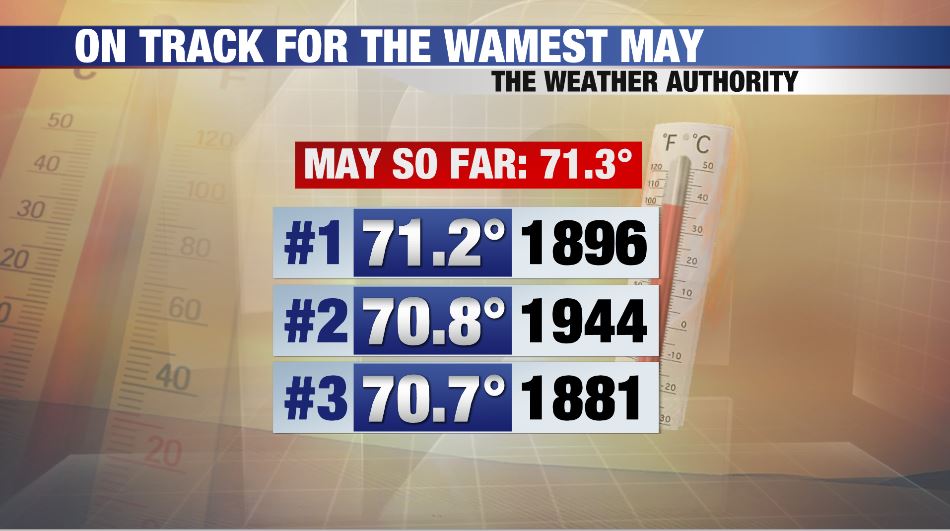
After a snowy, wintry first month of meteorological spring, March, and a chilly, snowy April, we are on track for the warmest May on record.
This summer heat immediately after our cold first two months of meteorological spring has had interesting consequences. We are rapidly making up for lost time as plants and plant pests race through their progressions and degree day accumulations pile up faster than the heaviest lake effect snow squall. It’s become tricky keeping up with the rapid fire pace. Keep in mind that we are experiencing summer conditions, and many plants were not acclimated. It will be interesting to see how things evolve going forward. No cool down is in sight as the summer of 2018 is off to a rip roaring start. Spring? I don’t care what the calendar says. Spring 2018 is over.


