Cover up! Polar Vortex lobe visits the eastern US bringing record challenging cold, hard freezes, and record challenging snow for some.

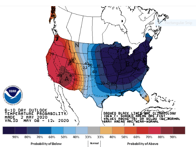
Sunday morning I blogged Polar vortex in May? Looks like it. You may want to hold off planting those tender annuals. Right on schedule, the cold air is arriving with the coldest air scheduled to cross the eastern US Friday into Sunday.

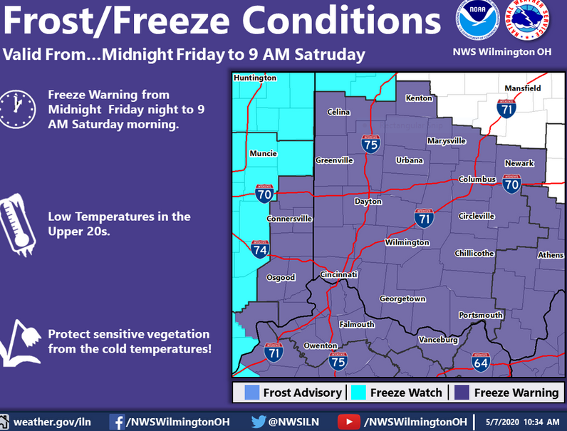
Rain may mix with snow Friday in parts of Ohio and a slushy accumulation can’t be ruled out in spots. A hard freeze is forecast in the Ohio valley Saturday morning. Freeze watches are already out for most of the Ohio valley and as far south as central and eastern Tennessee and even north Georgia.

Click on the map above for detailed alerts.
Southern Florida NE Gulf N of 25N E of 87W Gulf from 22N to 25N E of 87W including Straits of Florida NW Gulf including Stetson Bank N Central Gulf including Flower Garden Banks Marine Sanctuary W Central Gulf from 22N to 26N W of 94W Central Gulf from 22N to 26N between 87W and 94W Atlantic from 27N to 31N W of 77W Atlantic from 27N to 31N between 70W and 77W Atlantic from 27N to 31N between 65W and 70W Bahamas N of 22N including the Cay Sal Bank Atlantic from 22N to 27N E of Bahamas to 70W Tropical N Atlantic from 15N to 19N between 55W and 60W Caribbean N of 18N between 76W and 85W including the Cayman Basin Caribbean N of 18N between 76W and 85W including the Cayman Basin Caribbean approaches to the Windward Passage Atlantic S of 22N W of 70W including approaches to the Windward Passage Newport/Morehead City, NC Brownsville, TX Corpus Christi, TX Houston/Galveston, TX New Orleans, LA Lake Charles, LA Mobile, AL Tallahassee, FL Tampa, FL Miami, FL Key West, FL Florida Keys Miami, FL Melbourne, FL Jacksonville, FL Charleston, SC Wilmington, NC Baltimore/Washington, DC Wakefield, VA Philadelphia/Mt. Holly, PA/NJ New York, NY Boston, MA Gray/Portland, ME Intra Coastal Waters from Schoodic Point ME to Stonington ME Coastal Waters from Schoodic Point ME to Stonington ME out 25 NM Waters from Eastport ME to Stonington ME from 25 to 40 NM Northeast Minnesota and Northern Wisconsin Northern Michigan Northern Michigan Northern Michigan East Central Wisconsin - Green Bay East Central Wisconsin - Green Bay Southern and Southeastern Wisconsin Northeastern Illinois and Northwestern Indiana - Chicago Northern Indiana and Northwestern Ohio Southwestern Michigan Northeast Michigan - Gaylord Northeast Michigan - Gaylord Northeast Michigan - Gaylord Southeastern Michigan - Detroit Southeastern Michigan - Detroit Southeastern Michigan - Detroit Northern Ohio Western New York - Buffalo Western New York - Buffalo Northern Michigan Los Angeles, CA San Diego, CA San Francisco Bay Area/Monterey, CA Eureka, CA Medford, OR Portland, OR Seattle, WA Los Angeles Area Los Angeles Area Los Angeles Area Los Angeles Area Los Angeles Area Los Angeles Area South Central California San Francisco Area Western Nevada North Central California Northwest California Coast Southwest Oregon and Northern California Northeast Oregon and Southeast Washington Northwest Oregon Northwest Washington Eastern Washington and Northern Idaho Southern Nevada, Southeastern California and Northwestern Arizona - Las Vegas Southwestern California - San Diego Central Arizona and California Deserts Southeast Arizona Northern Arizona Utah Northern and Northeastern Nevada Southwestern Idaho and Eastern Oregon Southeastern Idaho Western Montana and Central Idaho Central Montana - Great Falls Northeastern Montana Southeastern Montana Western Wyoming Southeastern Wyoming and Western Nebraska Northeastern Colorado Western Colorado and Eastern Utah Southeastern Colorado Northern and Central New Mexico Southern New Mexico and extreme Western Texas - El Paso Texas and Oklahoma Lubbock and South Plains Texas Western Texas and Southeastern New Mexico Western South Dakota and Northeastern Wyoming Northwestern Kansas and East Central Colorado - Goodland Central Nebraska - North Platte North Central Kansas and South Central Nebraska Southeastern South Dakota, Southwestern Minnesota, and Northwestern Iowa Northern and Northeastern South Dakota Western North Dakota Eastern Nebraska and Southwestern Iowa - Omaha Valley Northeastern Kansas Southeastern Kansas Southwestern Kansas - Dodge City Central Oklahoma Eastern Oklahoma and Northwestern Arkansas Dallas and Fort Worth Central Texas - San Angelo Austin and San Antonio Texas Corpus Christi, Victoria, and Laredo Texas Southern Texas Texas - Houston/Galveston Southeast Texas and Southwest Louisiana Northern Louisiana and Eastern Texas - Shreveport Arkansas Southwestern Missouri Northwestern Missouri Central Iowa Southern Minnesota Northeastern North Dakota and Northwestern Minnesota Northeast Minnesota and Northern Wisconsin Southwestern Wisconsin, Southeastern Minnesota, and Northeast Iowa Eastern Iowa and Northwestern Illinois - Quad Cities Eastern Missouri - West Central Illinois Western Tennessee, Eastern Arkansas and Northern Mississippi - Memphis Central Mississippi Southeastern Louisiana Middle Tennessee Northern Alabama Central Alabama Mobile - Pensacola West Central Florida East Central Florida Panhandle of Florida and Southwestern Georgia Northeast Florida and Southeast Georgia Northern and Central Georgia Low Country of South Carolina and Georgia Northeastern South Carolina and Southeastern North Carolina - Wilmington Central South Carolina and CSRA Western North Carolina and Northwest South Carolina Eastern Tennessee Eastern Kentucky Central Kentucky Southern Illinois and Indiana, Southeastern Missouri and Western Kentucky Central and East Central Illinois Central Indiana Northeastern Illinois and Northwestern Indiana - Chicago Southern and Southeastern Wisconsin East Central Wisconsin - Green Bay Northern Michigan Northeast Michigan - Gaylord Northeast Michigan - Gaylord Southeastern Michigan - Detroit Southwestern Michigan Northern Indiana and Northwestern Ohio Southwestern Ohio Northern Kentucky West Virginia Western Virginia, Southeast West Virginia, and Northwest North Carolina Central North Carolina - Raleigh Eastern North Carolina Eastern Virginia, Southern Maryland and Northeast North Carolina Washington D.C., Central Maryland, Northern Virginia, Eastern West Virginia Western Pennsylvania, East Central Ohio and Extreme Western Maryland Northern Ohio Central Pennsylvania New Jersey, Delaware, and Southeastern Pennsylvania New York City and Surrounding Areas South Central New York and Northeastern Pennsylvania Western New York - Buffalo Eastern New York and Western New England Areas Boston and Surrounding Areas Northern Vermont and New York Southern Maine and New Hampshire Northern Maine Gulf of Maine to the Hague Line Georges Bank between Cape Cod and 68W north of 1000 fathoms South of New England between the Great South Channel and Montauk Point to 1000 fathoms South of Long Island between Montauk Point and Sandy Hook to 1000 fathoms Hudson Canyon to Baltimore Canyon to 1000 fathoms Baltimore Canyon to Cape Charles Light to 100 NM offshore Cape Charles Light to Currituck Beach Light to 100 NM offshore Currituck Beach Light to Cape Hatteras to 100 NM offshore Cape Hatteras to Cape Fear to 100 NM offshore Cape Fear to 31N to 1000 FM Georges Bank between 68W and the Hague Line East of 69W to the Hague Line between 1000 fathoms and 39N East of 69W and south of 39N to 250 NM offshore Between 1000 fathoms and 38.5N west of 69W Baltimore Canyon to 69W east of 1000 fathoms and south of 38.5N to 250 NM offshore Baltimore Canyon to Hatteras Canyon between 100 NM and 250 NM offshore Hatteras Canyon to Cape Fear 100 NM and 250 NM offshore Cape Fear to 31N east of 1000 fathoms to 250 NM offshore Cape Flattery to Cape Shoalwater between 60 NM and 150 NM offshore Cape Shoalwater to Cape Lookout between 60 NM and 150 NM offshore Cape Lookout to Florence, OR between 60 NM and 150 NM offshore Florence, OR to Point St. George between 60 NM and 150 NM offshore Point St. George to Point Arena between 60 NM and 150 NM offshore Point Arena to Pigeon Point between 60 NM and 150 NM offshore Pigeon Point to Point Piedras Blancas between 60 NM and 150 NM offshore Point Piedras Blancas to Santa Cruz Island, CA between 60 NM and 150 NM offshore Santa Cruz Island, CA to San Clemente Island, CA between 60 NM and 150 NM offshore Cape Flattery to Cape Shoalwater between 150 NM and 250 NM offshore Cape Shoalwater to Cape Lookout between 150 NM and 250 NM offshore Cape Lookout to Florence, OR between 150 NM and 250 NM offshore Florence, OR to Point St. George between 150 NM and 250 NM offshore Point St. George to Point Arena between 150 NM and 250 NM offshore Point Arena to Pigeon Point between 150 NM and 250 NM offshore Pigeon Point to Point Piedras Blancas between 150 NM and 250 NM offshore Point Piedras Blancas to Santa Cruz Island, CA between 150 NM and 250 NM offshore Santa Cruz Island, CA to 120W between 150 NM and 250 NM offshore San Clemente Island, CA to Guadalupe Island from 60 NM Offshore west to 120W Juneau, AK Fairbanks, AK Anchorage, AK Western US Arctic Offshore Eastern US Arctic Offshore Bering Sea offshore 171 degrees West to 180 degrees and north of 56 degrees North Bering Sea offshore 171 degrees West to 180 degrees and south of 56 degrees North Pribilof Islands (St. Paul and St. George) Bering Sea offshore east of 171 degrees West Gulf of Alaska offshore north of 57 degrees North and west of 144 degrees West Gulf of Alaska offshore south of 57 degrees North north of 55 degrees North and west of 144 degrees West Gulf of Alaska north of 55 degrees North and east of 144 degrees West Juneau, AK Honolulu, HI Hawaiian Offshore Waters

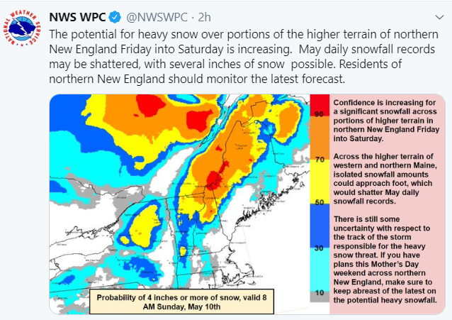
Record snows are possible in northern New England on Mother’s Day!

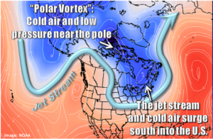
The term “polar vortex” is often misused and abused in the media. The National Weather Service reminds us that the polar vortex is a large area of low pressure and cold air surrounding both of the Earth’s poles. It ALWAYS exists near the poles, but weakens in summer and strengthens in winter. The term “vortex” refers to the counter-clockwise flow of air that helps keep the colder air near the Poles.

Polar Vortex, What is it? 

Forecasts and projections in this post are from NOAA US National Weather Service. Commentary from other meteorologists may also be employed in analysis as well as my 50 years as a weather watcher and horticulturist.


Polar vortex in May? Looks like it. You may want to hold off planting those tender annuals.

Garden centers have been buzzing with activity this spring and flowers and  tender vegetables are flying off the shelves and into the ground. We are past the “official” last frost date in Cincinnati, right? Time to plant tomatoes, peppers, and impatiens, right?

Well, not so fast. Mother nature didn’t get the memo that the climate is warming and doesn’t recognize the warmer USDA hardiness zones and last frost dates. I have been saying all along that warming everything up was  unwise. We may see why this year.

You know that polar vortex which was absent from the US and tucked away in the arctic this winter? Well, it appears set to make a rare and unusual May appearance. Widespread frosts and some freezes will come down into the Great Lakes and New England and may even visit the Ohio and Tennessee valleys over the next couple weeks. Temperatures will fall well below normal all the way down to the gulf coast. There may even be some May snow in the Great Lakes and New England.

So, if you have been waiting to plant your tender plants, I would wait some more. If you have them in the ground, good luck. You heard it here first. The cold train is already pulling into the station with the coldest air expected this weekend. Temperatures will only slowly moderate after that (Revised last paragraph on 5.5.20200).

Soil Moisture Condition Monitoring Weekly Report: Near Normal

United States Drought Monitor

Station Number: OH-HM-24
Station Name: Cheviot 3.4 W
Report Date: 5/2/2020
Submitted: 5/02/2020 6:35 AM
Scale Bar: Near Normal
Description:

1.21 inches of rain in the past week. Grass is lush. Conditions are normal for this time of year.

Categories:
General Awareness
Agriculture
Plants & Wildlife

Updated observed freeze damage in the Cincinnati area by species from mid-April 2020 freeze to 23.7 F. More cold possible in the Ohio Valley and can’t rule out more frost. April 29, 2020

This report is specifically for the Arbor Doctor’s location 3.4 miles west of Cheviot, OH, in the western suburbs of Cincinnati in southwest Ohio. This location is also an official cooperative observation site for the National Weather Service listed as Cheviot 3W.

What is the Condition Monitoring Report? See these links for more information:

Explanation of scale bar>>>

Search condition monitoring reports for the entire US>>>  

CoCoRaHS Condition Monitoring Report Map>>> 

Please remember to water…correctly!

Water once per week, one inch per week, under the entire branch spread, in the absence of rain, May through November. Either rainfall or your watering should equal the one inch per week. Put out a sprinkler and a straight sided soup can or rain gauge and measure one inch per week.

11-inch capacity rain gauge  

Taylor rain gauge   

Watering: How and when>>>

Watering Trees and Shrubs>>>


Soil Moisture Index:

Meteorological Versus Astronomical Seasons. Spring is here!

Spring: March 1-May 31; Summer: June 1-August 31; Fall: September 1-November 30; Winter: December 1-February 28 (29)

You may have noticed that Arbor Doctor, meteorologists and climatologists define seasons differently from “regular” or astronomical spring, summer, fall, and winter. So, why do  meteorological and astronomical seasons begin and end at different times? Read more here>>>

Nearly half the country has had its coldest day by the first day of calendar winter. That is why meteorological winter makes the most sense.

 Spring leaf out (click on map to enlarge):

Comparison of 2020 spring leaf out to average from 1981-2010

Spring bloom index (Click on map to enlarge):

Comparison of 2020 spring bloom to average from 1981-2010