
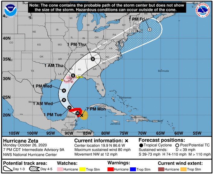
Two weeks ago computer models began hinting at an east coast storm or hurricane which would strike near Halloween then pull down cold air. Hurricane Zeta has formed but it will move a bit farther west than first thought.
Hurricane conditions and dangerous storm surge are expected in portions of the northern Yucatan Peninsula of Mexico through early Tuesday. Through Tuesday, heavy rainfall is expected across the Yucatan Peninsula, the Cayman Islands, and central to western Cuba, which could lead to flash flooding in urban areas.
Hurricane conditions and life-threatening storm surge are possible along portions of the northern Gulf Coast on Wednesday, and Storm Surge and Hurricane Watches are in effect. Residents in the watch areas should follow any advice given by local officials.
Meanwhile, a winter storm has settled into New Mexico, west Texas, and Oklahoma with winter storm and ice storm warnings, as well as winter weather advisories all the way south to the US-Mexico border.
After Zeta makes landfall, it will be shunted northeastward through the Tennessee valley and off the east coast while the southern plains low pivots eastward. The combination of Zeta moving in from the south and the southern plains low moving east will produce two swaths of very heavy rains, one from Louisiana into the Blue Ridge mountains and the other from Oklahoma and Kansas eastward into the Ohio valley, the mid-Atlantic and southern New England.
5 day Rainfall (melted snow) Forecast: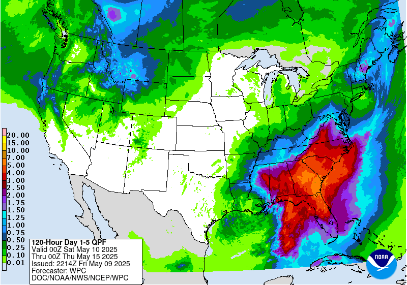
Rain and possibly a few thunderstorms will be in the offing for Thursday in the Ohio valley with significant rainfall amounts of 2-3″ expected, locally higher. The forecast is too far out to hone in on the specifics, but a steady moderate to heavy rainfall with some stronger showery elements will get wrung out along a warm front that will stall between the I-70 corridor and the Ohio River.
Between Tuesday night and Thursday, heavy rainfall is expected from portions of the central Gulf Coast into the southern Appalachians and Mid-Atlantic States near and in advance of Zeta. This rainfall will lead to flash, urban, small stream, and minor river flooding.
The good news is two fold. First, the more east to west trajectory will not drag down as much cold air. Second, all this will progress off the coast bringing a beautiful Halloween weekend to much of the country.
As we look ahead to early November, it is looking like a warming trend for much of the country as well as a return to dry weather.
8-14 Day Outlook:
Temperature Probability |
Precipitation Probability |