Sunday Night Snow Chances In Ohio Valley

A weather system will move across the Ohio valley Sunday night. The map below is the chance that 2 or more inches of snow will fall.


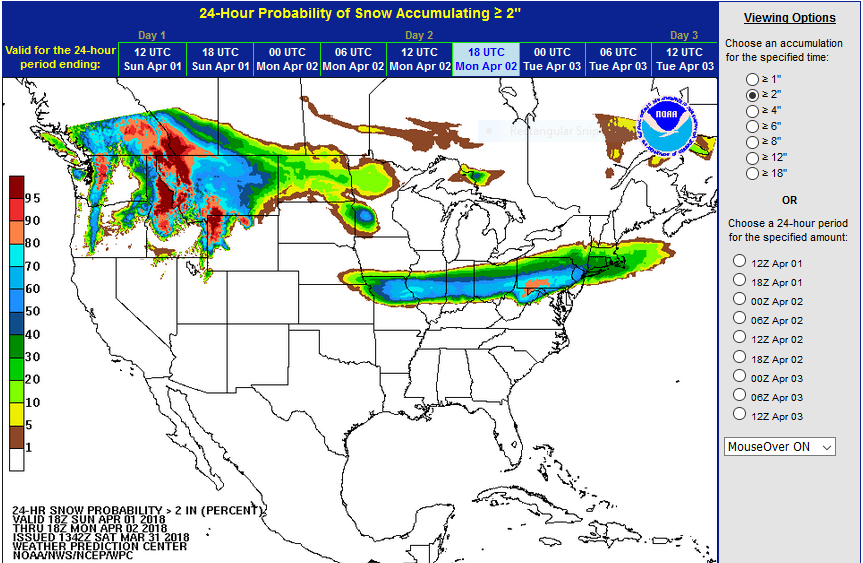
There are several variables in play. First, the chance of snow accumulation is not 100%. Second, temperatures will be marginal and some of the precipitation may fall as rain. Third, ground temperatures are also warm. Therefore, much of the snow would accumulate on natural surfaces. Temperatures will eventually fall to near or below freezing so some slick driving will be possible, especially on elevated surfaces. This is neither a sure thing nor a major winter storm, but it is something to be aware of.


Windy Saturday, Snow Chance Easter Sunday Night

Hazardous Weather Outlook
National Weather Service Wilmington OH
516 AM EDT Sat Mar 31 2018

This Hazardous Weather Outlook is for East Central Indiana,
Southeast Indiana, Northeast Kentucky, Northern Kentucky, 
Central Ohio, South Central Ohio, Southwest Ohio and West 
Central Ohio.

.DAY ONE...Today and Tonight.

Strong and gusty winds will develop this afternoon with the
approach of a deepening low pressure system. Wind gusts of 35 to 40
mph will be possible. The wind gusts will linger into the 
early evening hours.

.DAYS TWO THROUGH SEVEN...Sunday through Friday.

A fast moving upper level disturbance will bring a chance of 
rain and snow to the region Sunday night. At this time snow 
accumulations of less than inch are forecast.


.SPOTTER INFORMATION STATEMENT...

Spotter activation is not expected at this time.

Soil Moisture Condition Monitoring Weekly Report

 Station Number: OH-HM-24
Station Name: Cheviot 3.4 W
Report Date: 3/31/2018
Submitted: 3/31/2018 6:25 AM
Scale Bar: Severely Wet
Description:
 
2.95 inches of rain in the past 7 days. Soil is wet. Ground is completely saturated with water. Standing water is severe and abundant. Water bodies are very elevated.
 
Categories: General Awareness
Agriculture
Plants & Wildlife

This report is specifically for the Arbor Doctor’s location 3.4 miles west of Cheviot, OH, in the western suburbs of Cincinnati in southwest Ohio. This location is also an official cooperative observation site for the National Weather Service listed as Cheviot 3W.

What is the Condition Monitoring Report? See these links for more information:

https://www.cocorahs.org/Content.aspx?page=cm-scalebar

Search condition monitoring reports for the entire US>>>