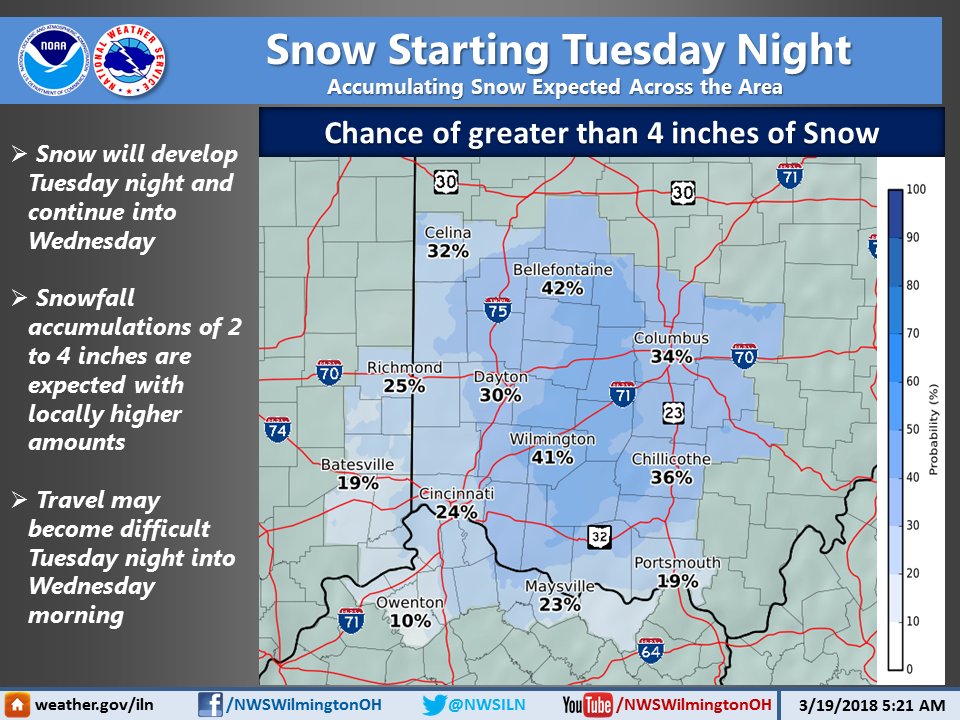
More snow is on the way starting tonight and continuing into Wednesday. Use caution if traveling as roads may become slick (especially Wednesday morning).
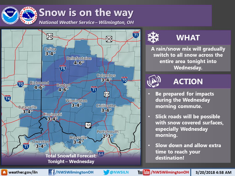
Snow, some heavy, is expected in Cincinnati and the Ohio valley Tuesday night and Wednesday. With the warm ground temperature and high sun angle, the greatest accumulation will occur at night and snow will have difficulty accumulating on pavement. Snow which does accumulate on pavement will be slushy and relatively short lived.
Arbor Doctor Snowfall Forecast On Natural Surfaces: 2-4 inches with isolated 4 -6 inch amounts possible.
Arbor Doctor Snowfall Forecast On Pavement: 1-2 slushy inches
Winter Weather Advisory
URGENT - WINTER WEATHER MESSAGE
National Weather Service Wilmington OH
624 AM EDT Tue Mar 20 2018
Franklin IN-Ripley-Dearborn-Ohio-Switzerland-Carroll-Gallatin-
Boone-Kenton-Campbell-Owen-Grant-Pendleton-Bracken-Robertson-
Mason-Lewis-Fayette OH-Pickaway-Fairfield-Butler-Warren-Clinton-
Ross-Hocking-Hamilton-Clermont-Brown-Highland-Adams-Pike-Scioto-
Including the cities of Brookville, Batesville, Milan,
Versailles, Lawrenceburg, Aurora, Rising Sun, Vevay, Carrollton,
Warsaw, Florence, Burlington, Oakbrook, Covington, Erlanger,
Independence, Newport, Alexandria, Owenton, Williamstown,
Crittenden, Dry Ridge, Falmouth, Butler, Augusta, Brooksville,
Mount Olivet, Maysville, Vanceburg, Tollesboro,
Washington Court House, Circleville, Lancaster, Pickerington,
Hamilton, Middletown, Fairfield, Oxford, Mason, Lebanon,
Springboro, Wilmington, Blanchester, Chillicothe, Logan,
Cincinnati, Milford, Georgetown, Mount Orab, Hillsboro,
Greenfield, West Union, Peebles, Waverly, Piketon, Portsmouth,
and Wheelersburg
624 AM EDT Tue Mar 20 2018

...WINTER WEATHER ADVISORY REMAINS IN EFFECT FROM 8 PM THIS
EVENING TO 8 PM EDT WEDNESDAY...

* WHAT...Snow expected. Total snow accumulations of 2 to 4
inches are expected. Some locally higher amounts will be
possible.

* WHERE...Portions of Southeast Indiana, Northeast and
Northern Kentucky and Central, South Central and Southwest
Ohio.

* WHEN...From 8 PM this evening to 8 PM EDT Wednesday.

* ADDITIONAL DETAILS...Plan on difficult travel conditions,
  including during the morning commute on Wednesday. Be
prepared for reduced visibilities at times.

PRECAUTIONARY/PREPAREDNESS ACTIONS...

A Winter Weather Advisory for snow means periods of snow will
cause primarily travel difficulties. Be prepared for snow covered
roads and limited visibilities, and use caution while driving.
Additional information can be found at www.weather.gov/iln as
well as on our Facebook and Twitter pages.