Early Alert on Weekend Snow Chance. Yes, Snow!

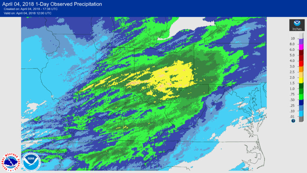
From the Wilmington OH National Weather Service:

Right now, the potential for 2-3" is very real through
early Saturday morning in Kentucky and southern portions of
Indiana and Ohio. These amounts will definitely be tweaked as
future forecasts hone in on the myriad of ingredients that are
combining to produce snow. There should be a sharp northern
boundary to the more significant snow accumulations, generally
found in Kentucky and then southern Ohio south of route 50.

April 3-4, 2018 Severe Thunderstorms, Flooding and Tornadoes

A weather system brought flooding rains, severe thunderstorms, damaging hail, and tornadoes to the Ohio valley on April 3, 2018. A summary from the Wilmington National Weather Service can be found here.

https://www.facebook.com/NWSWilmingtonOH/videos/1934814623256017/

[11:44 AM] Most of the area woke up on Monday with a fresh coating of snow on the ground. By Tuesday morning, rumbles of thunder likely woke some up as multiple rounds of heavy rain/thunderstorms created widespread flooding throughout parts of the area. By the afternoon, severe storms developed producing large hail, damaging winds, and even a few tornadoes. Last night and this morning, strong winds behind a cold front gusted in excess of 40 MPH and now much of the area is experiencing scattered snow showers with reduced visibility. Just another weather stretch in the Ohio Valley!

We’ve attached an animation of detected flashes from yesterday’s multiple rounds of storms — and as you can see, they were quite widespread and numerous. Lightning data is provided by Earth Networks and Vaisala.