Soil Moisture Condition Monitoring Weekly Report: Severely Wet

Station Number: OH-HM-24
Station Name: Cheviot 3.4 W
Report Date: 9/29/2018
Submitted: 9/29/2018 6:22 AM
Scale Bar: Severely Wet
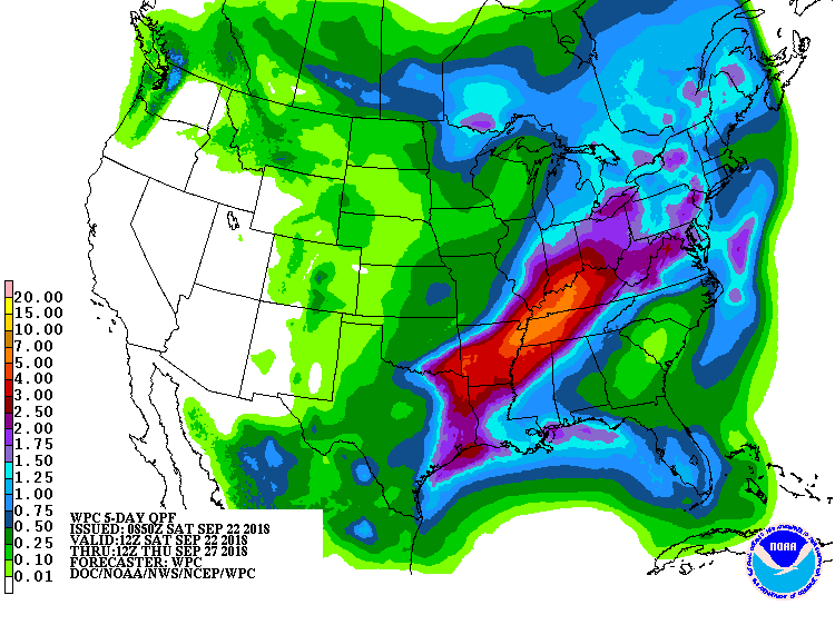
Description:
2.03 inches of rain in the past week, 11.49 inches of rain since September 1, 18.96 inches of rain in the past 60 days. Soil is wet. Ground is completely saturated with water. Standing water is abundant. Water bodies are very elevated. Lawns are lush and growing as if it’s spring with very wet swales and ditches. Fields are wet. Landscape plants are green and lush. Leaf diseases are prevalent due to the very high moisture. Very little early fall color due to warm and wet weather. Very unusual conditions for late September.

Categories: General Awareness
Agriculture
Plants & Wildlife

This report is specifically for the Arbor Doctor’s location 3.4 miles west of Cheviot, OH, in the western suburbs of Cincinnati in southwest Ohio. This location is also an official cooperative observation site for the National Weather Service listed as Cheviot 3W.

What is the Condition Monitoring Report? See these links for more information:

Explanation of scale bar>>>

Search condition monitoring reports for the entire US>>>

Heavy rain, flooding, severe storms all possible this week in Ohio Valley. September rainfall already 6.79 inches above normal.


Hazardous Weather Outlook National Weather Service Wilmington OH 504 AM EDT Sun Sep 23 2018

The potential exits for heavy rain with several rounds of showers and thunderstorms expected during the Monday through Wednesday time frame. Some of this heavy rain may lead to flooding. Strong to severe storms will be possible late Tuesday afternoon and Tuesday night ahead of a cold front.
The main threat will be damaging winds.

INZ050-058-059-066-073>075-080-KYZ089>093-OHZ026-034-035-042>046- 051>056-060>065-070>074-077-078-080-082-240915- Wayne-Fayette IN-Union IN-Franklin IN-Ripley-Dearborn-Ohio- Switzerland-Carroll-Gallatin-Boone-Kenton-Campbell-Hardin-Mercer- Auglaize-Darke-Shelby-Logan-Union OH-Delaware-Miami-Champaign-Clark- Madison-Franklin OH-Licking-Preble-Montgomery-Greene-Fayette OH- Pickaway-Fairfield-Butler-Warren-Clinton-Ross-Hocking-Hamilton- Clermont-Highland-Pike- 504 AM EDT Sun Sep 23 2018

This Hazardous Weather Outlook is for East Central Indiana, Southeast Indiana, Northern Kentucky, Central Ohio, South Central Ohio, Southwest Ohio and West Central Ohio.

September rainfall at Cheviot OH 3W is currently 9.62 inches compared to the average September rainfall of 2.83. 2018 rainfall to date is 49.79 inches. Normal annual rainfall through December 31 is 43.72 inches.


Soil Moisture Condition Monitoring Weekly Report: Mildly Wet

Station Number: OH-HM-24
Station Name: Cheviot 3.4 W
Report Date: 9/22/2018
Submitted: 9/22/2018 6:30 AM
Scale Bar: Mildly Wet
Description:
 
Only 0.19 inches of rain over the past 7 days with hot weather and fast drying rates. Surface moisture has really dried up. However, with 9.46 inches of rain for the month, grass continues to grow like it’s April and trees and shrubs are healthy and lush. The only plants which may be a bit dry are shallow rooted plants and annuals. More heavy rain is in the forecast so the prospect of moving into drought is very low.
 
Categories:
General Awareness
Agriculture
Plants & Wildlife

This report is specifically for the Arbor Doctor’s location 3.4 miles west of Cheviot, OH, in the western suburbs of Cincinnati in southwest Ohio. This location is also an official cooperative observation site for the National Weather Service listed as Cheviot 3W.

What is the Condition Monitoring Report? See these links for more information:

Explanation of scale bar>>>

Search condition monitoring reports for the entire US>>>