
Hazardous Weather Outlook National Weather Service Wilmington OH 504 AM EDT Sun Sep 23 2018
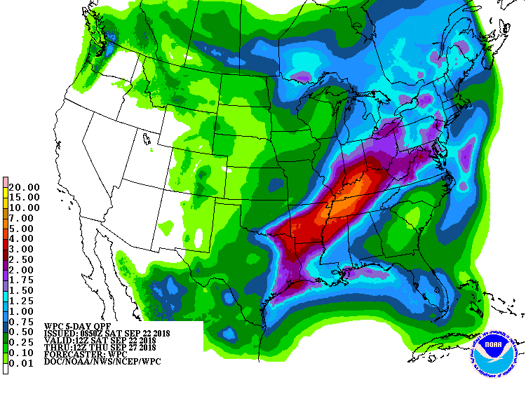
The potential exits for heavy rain with several rounds of showers and thunderstorms expected during the Monday through Wednesday time frame. Some of this heavy rain may lead to flooding. Strong to severe storms will be possible late Tuesday afternoon and Tuesday night ahead of a cold front.
The main threat will be damaging winds.
INZ050-058-059-066-073>075-080-KYZ089>093-OHZ026-034-035-042>046- 051>056-060>065-070>074-077-078-080-082-240915- Wayne-Fayette IN-Union IN-Franklin IN-Ripley-Dearborn-Ohio- Switzerland-Carroll-Gallatin-Boone-Kenton-Campbell-Hardin-Mercer- Auglaize-Darke-Shelby-Logan-Union OH-Delaware-Miami-Champaign-Clark- Madison-Franklin OH-Licking-Preble-Montgomery-Greene-Fayette OH- Pickaway-Fairfield-Butler-Warren-Clinton-Ross-Hocking-Hamilton- Clermont-Highland-Pike- 504 AM EDT Sun Sep 23 2018
This Hazardous Weather Outlook is for East Central Indiana, Southeast Indiana, Northern Kentucky, Central Ohio, South Central Ohio, Southwest Ohio and West Central Ohio.
September rainfall at Cheviot OH 3W is currently 9.62 inches compared to the average September rainfall of 2.83. 2018 rainfall to date is 49.79 inches. Normal annual rainfall through December 31 is 43.72 inches.