Soil Moisture Condition Monitoring Weekly Report: Severely Wet

Station Number: OH-HM-24
Station Name: Cheviot 3.4 W
Report Date: 2/16/2019
Submitted: 2/16/2019 7:26 AM
Scale Bar: Severely Wet
Description:

2.08 inches of liquid and melted precipitation over the past 7 days and 5.94 inches in February. Ground is completely saturated with water. Standing water is severe and abundant. Water bodies are very elevated. Flooding was widespread over the past week. Rivers are beginning to recede but are still near flood stage.

Categories:
General Awareness
Agriculture
Plants & Wildlife

This report is specifically for the Arbor Doctor’s location 3.4 miles west of Cheviot, OH, in the western suburbs of Cincinnati in southwest Ohio. This location is also an official cooperative observation site for the National Weather Service listed as Cheviot 3W.

What is the Condition Monitoring Report? See these links for more information:

Explanation of scale bar>>>

Search condition monitoring reports for the entire US>>>

Soil Moisture Condition Monitoring Weekly Report: Severely Wet

Station Number: OH-HM-24
Station Name: Cheviot 3.4 W
Report Date: 2/9/2019
Submitted: 2/09/2019 6:11 AM
Scale Bar: Severely Wet
Description:

3.87 inches of rain in the past 7 days. Ground is completely saturated with water. Standing water is severe and abundant. Most rivers near or above flood stage. Some roads are closed due to flooding. Many fields are partially or completely flooded.

Categories:
General Awareness
Agriculture
Plants & Wildlife

This report is specifically for the Arbor Doctor’s location 3.4 miles west of Cheviot, OH, in the western suburbs of Cincinnati in southwest Ohio. This location is also an official cooperative observation site for the National Weather Service listed as Cheviot 3W.

What is the Condition Monitoring Report? See these links for more information:
Explanation of scale bar>>>

Search condition monitoring reports for the entire US>>>

6 more weeks of winter? Yes, no, and maybe. The wild pattern continues for the rest of February.

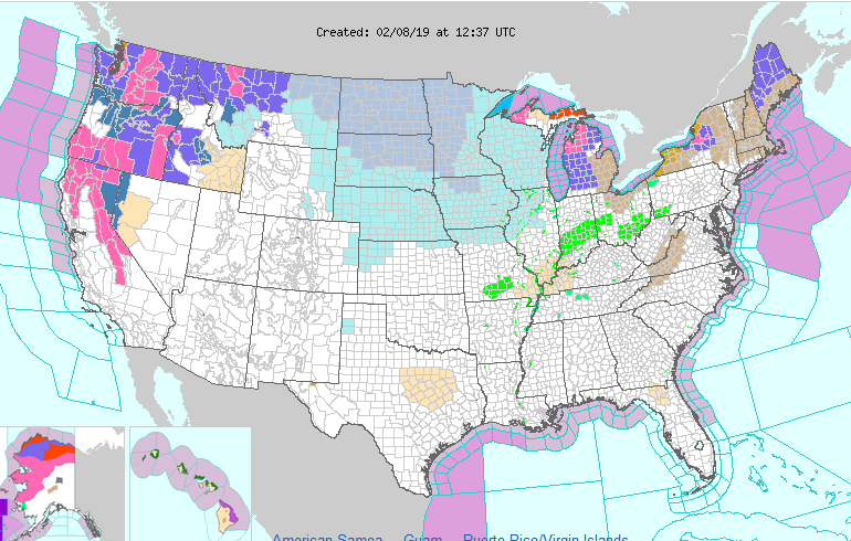
Yesterday it was 65 in Cincinnati, this morning it is 20. The promised return to winter is dominating the upper midwest, Great Lakes, and west as shown on this map. Winter storm warnings are up for the western mountains for a continual parade of winter storms while the blue shades in the upper midwest are wind chill advisories and warnings. The green in the Ohio valley is residual flooding concerns.

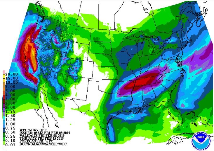
The 7 day liquid precipitation outlook shows storminess out west with an additional 10+ feet of snow possible in the Sierra Nevadas and more storminess in the southeast. Cincinnati will have a couple really cold, wintry days followed by several days of unsettled weather and precipitation. While no big snow is currently forecast, some accumulation cannot be ruled out from Sunday into next week.

The 6-10 day outlook shows real winter continuing in the northwest half of the country, spring-like weather in the southeast, and Cincinnati on the battleground border.

The battle between winter and spring will produce abundant storminess and precipitation where the two seasons meet. This means there is no end in sight to the precipitation train from the west coast into the Ohio valley and into New England. Precipitation type will depend on exactly where that battle line sits when any given storm goes through.

So, keep the snow shovel handy and the sump pump engaged. The wild February ride continues.