…WINTER WEATHER ADVISORY IN EFFECT FROM 10 AM FRIDAY TO 10 AM EST SATURDAY…

[3:51 PM] A Winter Weather Advisory has been issued for the upcoming winter system expected to move through late tonight and continue through the early hours of Saturday. Be prepared for winter driving conditions if you are planning travel Friday into Friday night.

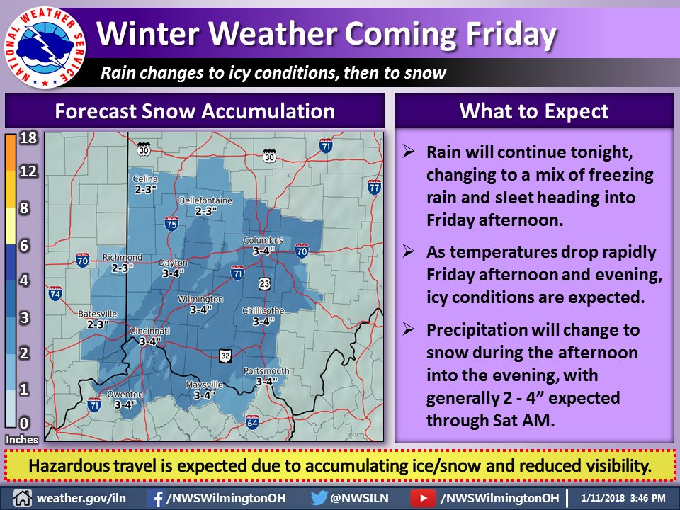
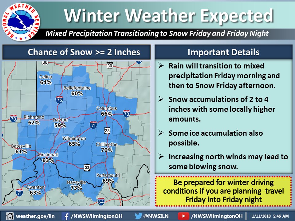
A winter weather advisory has been issued for Cincinnati. Total snow accumulations of 2 to 4 inches and ice accumulations of up to one tenth of an inch are expected. With warm ground temperatures, ice should not be a major problem on the ground. Most ice build up would be on trees and elevated surfaces such as bridges.

Trees do not have serious problems until 1/2 inch or ice accumulates and this storm should be much less. An extended period of sleet would increase icing issues but that does not currently appear to be a big concern. Storm total snow accumulations have not really changed but icing potential has lessened some.


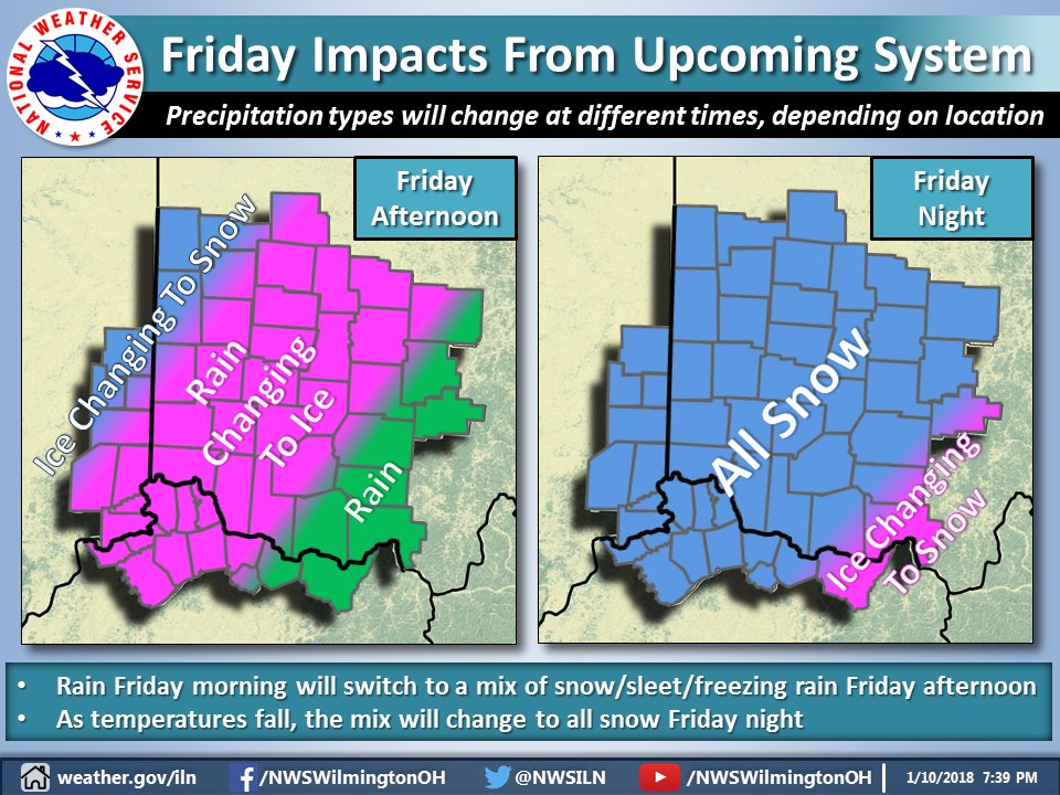
This storm came together a bit differently than earlier expected. It will still have a significant impact but much less than earlier expected. As usual, many people jumped on earlier computer models of 20 inches of snow. One internet weather service said this would be the “storm of a lifetime”. It won’t be. It will make a mess of evening rush hour in Cincinnati. Conditions may start deteriorating near or shortly after noon.

Temperatures will be frigid over the weekend with some wind on the back side of the storm Saturday morning. Another system could give us an inch or two of snow Monday with more arctic cold to follow. A significant warm-up is expected in about a week or so.

URGENT - WINTER WEATHER MESSAGE
National Weather Service Wilmington OH
323 PM EST Thu Jan 11 2018

Dearborn-Ohio-Switzerland-Carroll-Gallatin-Boone-Kenton-Campbell-
Owen-Grant-Pendleton-Bracken-Union OH-Delaware-Champaign-Clark-
Madison-Franklin OH-Licking-Montgomery-Greene-Fayette OH-Butler-
Warren-Clinton-Hamilton-Clermont-Brown-Highland-
Including the cities of Lawrenceburg, Aurora, Rising Sun, Vevay,
Carrollton, Warsaw, Florence, Burlington, Oakbrook, Covington,
Erlanger, Independence, Newport, Alexandria, Owenton,
Williamstown, Crittenden, Dry Ridge, Falmouth, Butler, Augusta,
Brooksville, Marysville, Delaware, Urbana, Springfield, London,
West Jefferson, Plain City, Columbus, Newark, Dayton, Kettering,
Beavercreek, Fairborn, Xenia, Washington Court House, Hamilton,
Middletown, Fairfield, Oxford, Mason, Lebanon, Springboro,
Wilmington, Blanchester, Cincinnati, Milford, Georgetown,
Mount Orab, Hillsboro, and Greenfield
323 PM EST Thu Jan 11 2018

...WINTER WEATHER ADVISORY IN EFFECT FROM 10 AM FRIDAY TO 10 AM
EST SATURDAY...

* WHAT...Mixed precipitation expected. Plan on difficult travel
  conditions. Total snow accumulations of 2 to 4 inches and ice
  accumulations of up to one tenth of an inch are expected.

* WHERE...Portions of Southeast Indiana, Northern Kentucky and
  Central, Southwest and West Central Ohio.

* WHEN...From 10 AM Friday to 10 AM EST Saturday.

* ADDITIONAL DETAILS...Be prepared for reduced visibilities at
  times.

PRECAUTIONARY/PREPAREDNESS ACTIONS...

A Winter Weather Advisory means that periods of snow, sleet or
freezing rain will cause travel difficulties. Be prepared for
slippery roads and limited visibilities, and use caution while
driving. Additional information can be found at
www.weather.gov/iln as well as on our Facebook and Twitter pages.

A winter weather advisory has been issued instead of a winter storm warning because of the peculiar and confusing nature of National Weather Service Wilmington’s advisory criteria. Even though the greatest number of accidents occur at lower accumulation amounts, lesser advisories are applied to lower amounts than higher amounts. Advisories and warnings are not generally tied to pavement temperatures and seasonal differences. A 6-inch snow in April which does not stick on pavement would have a warning while a 3-inch snow in January, which greatly affects roads, gets an advisory. Additionally, NWS Wilmington has divided their forecast area so different zones have different advisory criteria. Don’t try to figure it out. You’ll get a headache.

Image result for Wilmington OH NWS winter weather advisory criteria

watch2


Winter Storm Watch in effect from January 12, 07:00 AM EST until January 13, 10:00 AM EST

Winter Storm Watch

While total snow accumulations will be marginal for Winter Storm criteria, a lot of questions remain with this storm. Significant freezing rain and/or sleet may fall during transition from rain to snow. More freezing rain and sleet would cut down on snow totals. It is important to remember for those doing snow removal that sleet is very problematic.

You have heard that one inch of rain equals 10 inches of snow, a ratio which is often much higher. I know from past experience that one inch of sleet equals 10-20 inches of snow in weight because of its high density and lack of air pockets. If we get extended freezing rain we could have ice and power line problems. Extended sleet would cut down on snow totals but would be as problematic and as heavy to remove as heavy snow, 10-20 inches of snow weight if we get one inch of sleet. So, be prepared for significant driving and snow removal issues. Be careful with the ratios I discussed. I am not predicting 10-20 inches of snow (forecast is 2-4 inches), just the weight of such if we get an inch of sleet. 

Oh, and by the way, another couple inches of snow is possible Monday. Too early for details but it will be frigid for a few days before January thaw part II arrives.

–Ron Rothhaas

URGENT - WINTER WEATHER MESSAGE
National Weather Service Wilmington OH
411 AM EST Thu Jan 11 2018

Wayne-Fayette IN-Union IN-Franklin IN-Ripley-Dearborn-Ohio-
Switzerland-Carroll-Gallatin-Boone-Kenton-Campbell-Owen-Grant-
Pendleton-Bracken-Robertson-Mason-Lewis-Union OH-Delaware-Miami-
Champaign-Clark-Madison-Franklin OH-Licking-Preble-Montgomery-
Greene-Fayette OH-Pickaway-Fairfield-Butler-Warren-Clinton-Ross-
Hocking-Hamilton-Clermont-Brown-Highland-Adams-Pike-Scioto-
Including the cities of Richmond, Connersville, Liberty,
West College Corner, Brookville, Batesville, Milan, Versailles,
Lawrenceburg, Aurora, Rising Sun, Vevay, Carrollton, Warsaw,
Florence, Burlington, Oakbrook, Covington, Erlanger,
Independence, Newport, Alexandria, Owenton, Williamstown,
Crittenden, Dry Ridge, Falmouth, Butler, Augusta, Brooksville,
Mount Olivet, Maysville, Vanceburg, Tollesboro, Marysville,
Delaware, Troy, Piqua, Tipp City, Urbana, Springfield, London,
West Jefferson, Plain City, Columbus, Newark, Eaton, Camden,
Dayton, Kettering, Beavercreek, Fairborn, Xenia,
Washington Court House, Circleville, Lancaster, Pickerington,
Hamilton, Middletown, Fairfield, Oxford, Mason, Lebanon,
Springboro, Wilmington, Blanchester, Chillicothe, Logan,
Cincinnati, Milford, Georgetown, Mount Orab, Hillsboro,
Greenfield, West Union, Peebles, Waverly, Piketon, Portsmouth,
and Wheelersburg
411 AM EST Thu Jan 11 2018

...WINTER STORM WATCH IN EFFECT FROM FRIDAY MORNING THROUGH
SATURDAY MORNING...

* WHAT...Heavy mixed precipitation possible. Plan on difficult
  travel conditions, including through the Friday afternoon
  commute. Total snow accumulations of 2 to 4 inches and locally
  higher amounts. In addition ice accumulations of up to one
  tenth of an inch are possible.

* WHERE...Portions of East Central and Southeast Indiana,
  Northeast and Northern Kentucky and Central, Southwest and
  West Central Ohio.

* WHEN...From Friday morning through Saturday morning.

* ADDITIONAL DETAILS...Significant reductions in visibility are
  possible.

PRECAUTIONARY/PREPAREDNESS ACTIONS...

A Winter Storm Watch means there is potential for significant
snow, sleet or ice accumulations that may impact travel. Continue
to monitor the latest forecasts.

Day 7 image not available


Wednesday Evening Winter Storm Update

[7:54 PM] On Friday, we expect rain to change to a mix of freezing rain and sleet, before changing to snow. This changeover will happen at different times depending on your location. Everyone should be prepared for ice and snow accumulations Friday into Friday night.

[7:55 PM] Depending on the actual track and strength of the system, some areas will see heavier accumulations than others by Friday night. Stay tuned for further updates.

——————————————

This Hazardous Weather Outlook is for East Central Indiana,
Southeast Indiana, Northern Kentucky, Central Ohio, Southwest Ohio
and West Central Ohio.

.A low pressure system is forecast to move northeast from the
Tennessee Valley to the eastern Great Lakes Friday into Saturday.
Rain is expected to transition over to a wintry mix Friday afternoon
and then gradually change over to snow Friday night. Accumulating
snow will be likely along with some ice accumulation. Any slight
track differences with this system will have large implications on
the potential weather types and impacts. This weather event will have
to be watched carefully as the week progresses.

Point Forecast:
Mack North OH
39.16°N 84.69°W (Elev. 801 ft)
Friday
Rain before 4pm, then freezing rain and sleet. High near 39. North wind 11 to 16 mph. Chance of precipitation is 100%. New ice accumulation of less than a 0.1 of an inch possible. New sleet accumulation of less than one inch possible.
Friday Night
Snow, mainly before 4am. Low around 19. North wind 13 to 17 mph, with gusts as high as 28 mph. Chance of precipitation is 100%. New snow accumulation of 2 to 4 inches possible.
Saturday
A chance of snow, mainly before noon. Cloudy, with a high near 24. Chance of precipitation is 40%. New snow accumulation of less than a half inch possible.
Saturday Night
Mostly cloudy, with a low around 9.
Sunday
Mostly sunny, with a high near 23.

Day 7 image not available

Check back to the Arbor Doctor Weather Blog for future updates.