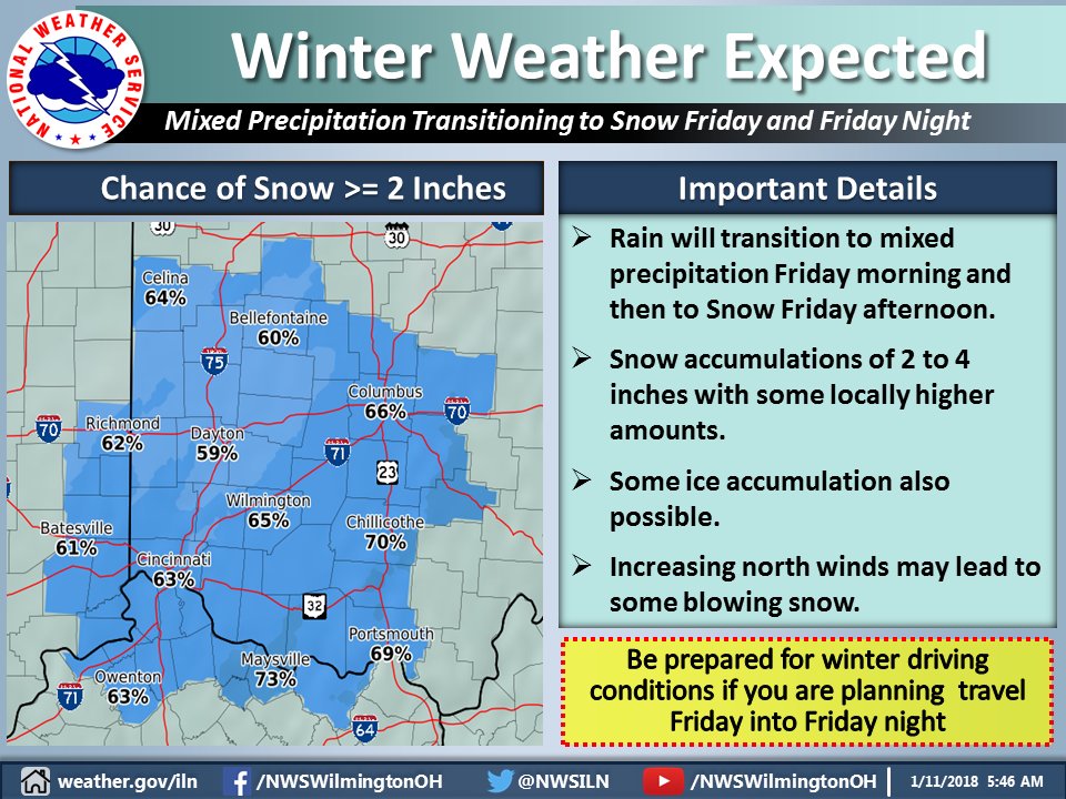
Winter Storm Watch
While total snow accumulations will be marginal for Winter Storm criteria, a lot of questions remain with this storm. Significant freezing rain and/or sleet may fall during transition from rain to snow. More freezing rain and sleet would cut down on snow totals. It is important to remember for those doing snow removal that sleet is very problematic.
You have heard that one inch of rain equals 10 inches of snow, a ratio which is often much higher. I know from past experience that one inch of sleet equals 10-20 inches of snow in weight because of its high density and lack of air pockets. If we get extended freezing rain we could have ice and power line problems. Extended sleet would cut down on snow totals but would be as problematic and as heavy to remove as heavy snow, 10-20 inches of snow weight if we get one inch of sleet. So, be prepared for significant driving and snow removal issues. Be careful with the ratios I discussed. I am not predicting 10-20 inches of snow (forecast is 2-4 inches), just the weight of such if we get an inch of sleet.
Oh, and by the way, another couple inches of snow is possible Monday. Too early for details but it will be frigid for a few days before January thaw part II arrives.
–Ron Rothhaas
URGENT - WINTER WEATHER MESSAGE
National Weather Service Wilmington OH
411 AM EST Thu Jan 11 2018

Wayne-Fayette IN-Union IN-Franklin IN-Ripley-Dearborn-Ohio-
Switzerland-Carroll-Gallatin-Boone-Kenton-Campbell-Owen-Grant-
Pendleton-Bracken-Robertson-Mason-Lewis-Union OH-Delaware-Miami-
Champaign-Clark-Madison-Franklin OH-Licking-Preble-Montgomery-
Greene-Fayette OH-Pickaway-Fairfield-Butler-Warren-Clinton-Ross-
Hocking-Hamilton-Clermont-Brown-Highland-Adams-Pike-Scioto-
Including the cities of Richmond, Connersville, Liberty,
West College Corner, Brookville, Batesville, Milan, Versailles,
Lawrenceburg, Aurora, Rising Sun, Vevay, Carrollton, Warsaw,
Florence, Burlington, Oakbrook, Covington, Erlanger,
Independence, Newport, Alexandria, Owenton, Williamstown,
Crittenden, Dry Ridge, Falmouth, Butler, Augusta, Brooksville,
Mount Olivet, Maysville, Vanceburg, Tollesboro, Marysville,
Delaware, Troy, Piqua, Tipp City, Urbana, Springfield, London,
West Jefferson, Plain City, Columbus, Newark, Eaton, Camden,
Dayton, Kettering, Beavercreek, Fairborn, Xenia,
Washington Court House, Circleville, Lancaster, Pickerington,
Hamilton, Middletown, Fairfield, Oxford, Mason, Lebanon,
Springboro, Wilmington, Blanchester, Chillicothe, Logan,
Cincinnati, Milford, Georgetown, Mount Orab, Hillsboro,
Greenfield, West Union, Peebles, Waverly, Piketon, Portsmouth,
and Wheelersburg
411 AM EST Thu Jan 11 2018

...WINTER STORM WATCH IN EFFECT FROM FRIDAY MORNING THROUGH
SATURDAY MORNING...

* WHAT...Heavy mixed precipitation possible. Plan on difficult
  travel conditions, including through the Friday afternoon
  commute. Total snow accumulations of 2 to 4 inches and locally
  higher amounts. In addition ice accumulations of up to one
  tenth of an inch are possible.

* WHERE...Portions of East Central and Southeast Indiana,
  Northeast and Northern Kentucky and Central, Southwest and
  West Central Ohio.

* WHEN...From Friday morning through Saturday morning.

* ADDITIONAL DETAILS...Significant reductions in visibility are
  possible.

PRECAUTIONARY/PREPAREDNESS ACTIONS...

A Winter Storm Watch means there is potential for significant
snow, sleet or ice accumulations that may impact travel. Continue
to monitor the latest forecasts.