
| < Previous MD |
 |
Mesoscale Discussion 0023 NWS Storm Prediction Center Norman OK 0158 PM CST Fri Jan 12 2018 Areas affected...Swrn through nern Ohio...nwrn Pennsylvania...wrn New York Concerning...Heavy snow Valid 121958Z - 130000Z SUMMARY...Moderate to heavy snow at up to 1 inch per hour rates may develop across areas near and southeast of Lake Erie through the 4-8 PM EST time frame. DISCUSSION...As large-scale upper troughing continues to dig into portions of the upper Great Lakes/Midwest region, and another trough pivots across and northeast of the Tennessee Valley, models indicate an area of strengthening lower/mid tropospheric frontogenetic forcing across parts of the lower Ohio Valley/Great Lakes region by early evening. Associated lift, including through the favorable dendritic growth zone, appears likely to be accompanied by a band of increasing precipitation rates across roughly the Interstate-71 corridor of Ohio, into the Cleveland metro area, and east northeastward through Buffalo and surrounding areas of western New York state. Coinciding with further low/mid-level cooling to sub-freezing temperatures, as a sharp cold front steadily advances southeastward, this is expected to become mostly moderate to heavy snow. This may include at least a couple hour period at rates near or in excess of 1 inch per hour, before heavier snow begins to develop/shift off to the east northeast of the lower Great Lakes region this evening. |
…WINTER WEATHER ADVISORY REMAINS IN EFFECT FROM 10 AM THIS MORNING TO 10 AM EST SATURDAY…
Or Maybe It’s A Winter Storm…
This is the type of thing which drives me nuts. No wonder the public gets impatient with weather forecasts. The National Weather Service has very confusing and contradictory headlines out right now on their website at the same time. Furthermore, just try to make sense of the warnings and advisories per the criteria at the bottom of this article.
Here’s the bottom line. Driving will get really bad, especially later this afternoon and tonight, with snow and ice covered roads and blowing snow.
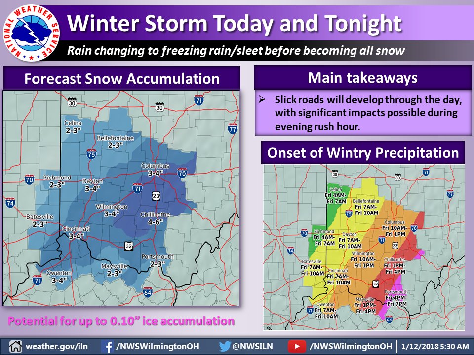
How much is expected? Take your pick:
NWS Wilmington Winter Weather Advisory wording for Hamilton County:
* WHAT…Mixed precipitation expected. Plan on difficult travel
conditions. Total snow accumulations of 2 to 4 inches and ice
accumulations of up to one tenth of an inch are expected.
NWS Wilmington Text Forecast wording for Hamilton County:
…WINTER WEATHER ADVISORY IN EFFECT FROM 10 AM THIS MORNING TO
10 AM EST SATURDAY…
.TODAY…Rain, freezing rain and sleet this morning, then sleet,
freezing rain, rain and snow this afternoon. Snow and sleet
accumulation an inch or less. Ice accumulation of up to a tenth
of an inch. Colder with highs in the lower 40s. North winds 15 to
20 mph with gusts up to 30 mph. Chance of precipitation
100 percent.
.TONIGHT…Snow, mainly in the evening. Total snow accumulation
of 3 to 5 inches. A trace of ice accumulation. Much colder with
lows around 15. North winds 15 to 20 mph with gusts up to 35 mph.
Chance of snow 100 percent.
If you don’t like those choices, here’s a third one from the same source:
Either way, expect it to get bad. That’s the take home message.
Frigid air for the next week with more accumulating snow likely Monday.
URGENT – WINTER WEATHER MESSAGE
National Weather Service Wilmington OH
403 AM EST Fri Jan 12 2018
INZ074-075-080-KYZ089>096-OHZ045-046-052>056-061-062-070-071-077-
078-121715-
/O.CON.KILN.WW.Y.0003.180112T1500Z-180113T1500Z/
Dearborn-Ohio-Switzerland-Carroll-Gallatin-Boone-Kenton-Campbell-
Owen-Grant-Pendleton-Union OH-Delaware-Champaign-Clark-Madison-
Franklin OH-Licking-Montgomery-Greene-Butler-Warren-Hamilton-
Clermont-
Including the cities of Lawrenceburg, Aurora, Rising Sun, Vevay,
Carrollton, Warsaw, Florence, Burlington, Oakbrook, Covington,
Erlanger, Independence, Newport, Alexandria, Owenton,
Williamstown, Crittenden, Dry Ridge, Falmouth, Butler,
Marysville, Delaware, Urbana, Springfield, London,
West Jefferson, Plain City, Columbus, Newark, Dayton, Kettering,
Beavercreek, Fairborn, Xenia, Hamilton, Middletown, Fairfield,
Oxford, Mason, Lebanon, Springboro, Cincinnati, and Milford
403 AM EST Fri Jan 12 2018
…WINTER WEATHER ADVISORY REMAINS IN EFFECT FROM 10 AM THIS
MORNING TO 10 AM EST SATURDAY…
* WHAT…Mixed precipitation expected. Plan on difficult travel
conditions. Total snow accumulations of 2 to 4 inches and ice
accumulations of up to one tenth of an inch are expected.
* WHERE…Portions of Southeast Indiana, Northern Kentucky and
Central, Southwest, and West Central Ohio.
* WHEN…From 10 AM this morning to 10 AM EST Saturday.
* ADDITIONAL DETAILS…Be prepared for reduced visibilities at
times.
PRECAUTIONARY/PREPAREDNESS ACTIONS…
A Winter Weather Advisory means that periods of snow, sleet or
freezing rain will cause travel difficulties. Be prepared for
slippery roads and limited visibilities, and use caution while
driving. Additional information can be found at
www.weather.gov/iln as well as on our Facebook and Twitter pages.
A winter weather advisory has been issued instead of a winter storm warning because of the peculiar and confusing nature of National Weather Service Wilmington’s advisory criteria. Even though the greatest number of accidents occur at lower accumulation amounts, lesser advisories are applied to lower amounts than higher amounts. Advisories and warnings are not generally tied to pavement temperatures and seasonal differences. A 6-inch snow in April which does not stick on pavement would have a warning while a 3-inch snow in January, which greatly affects roads, gets an advisory. Additionally, NWS Wilmington has divided their forecast area so different zones have different advisory criteria. Don’t try to figure it out. You’ll get a headache.

