Torrential rains, a rising Ohio River to the highest level seen in years, weekend chances for severe weather, and an encore of winter eventually. No boredom in the weather department!
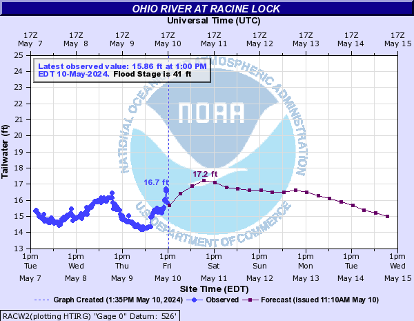
Despite the misprint, the Ohio River at Racine Lock on the Ohio-West Virginia border is projected to crest at a record high level of 60.5 feet:
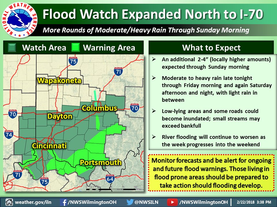
Ohio River Projected To Go Considerably Higher With Major Flooding At Some Points
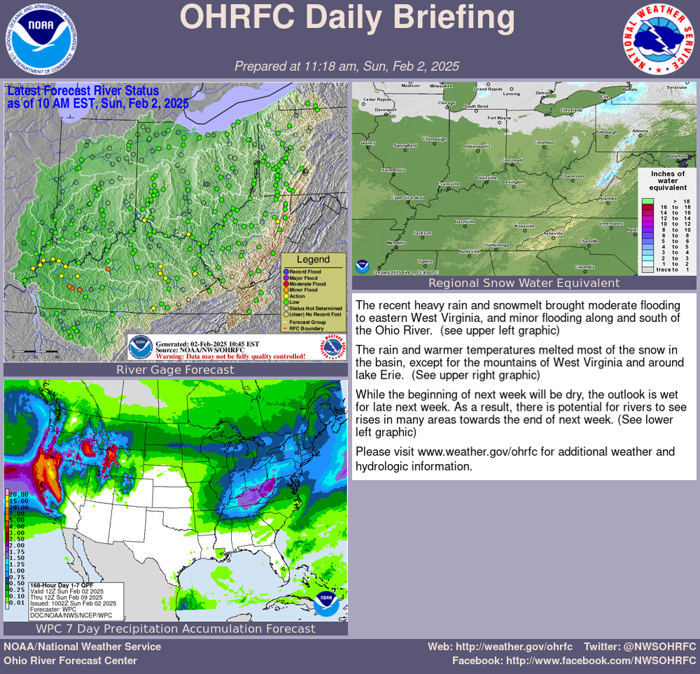
The updated Ohio River forecast would take the river to near 60 feet next week in Cincinnati. This is nearly 8 feet above flood stage and would have major impacts to the metro area. More heavy rains are forecast and a higher crest cannot be ruled out.
Additional rainfall over the Ohio River watershed will be 2-6 inches over the next 7 days.
Flood Watch
National Weather Service Wilmington OH
404 AM EST Thu Feb 22 2018

...MULTIPLE ROUNDS OF HEAVY RAINFALL EXPECTED INTO THE
WEEKEND...

INZ066-073>075-080-KYZ089>100-OHZ063>065-070>074-077>082-088-
221715-
/O.CON.KILN.FA.A.0003.000000T0000Z-180225T1500Z/
/00000.0.ER.000000T0000Z.000000T0000Z.000000T0000Z.OO/
Franklin IN-Ripley-Dearborn-Ohio-Switzerland-Carroll-Gallatin-
Boone-Kenton-Campbell-Owen-Grant-Pendleton-Bracken-Robertson-
Mason-Lewis-Fayette OH-Pickaway-Fairfield-Butler-Warren-Clinton-
Ross-Hocking-Hamilton-Clermont-Brown-Highland-Adams-Pike-Scioto-
Including the cities of Brookville, Batesville, Milan,
Versailles, Lawrenceburg, Aurora, Rising Sun, Vevay, Carrollton,
Warsaw, Florence, Burlington, Oakbrook, Covington, Erlanger,
Independence, Newport, Alexandria, Owenton, Williamstown,
Crittenden, Dry Ridge, Falmouth, Butler, Augusta, Brooksville,
Mount Olivet, Maysville, Vanceburg, Tollesboro,
Washington Court House, Circleville, Lancaster, Pickerington,
Hamilton, Middletown, Fairfield, Oxford, Mason, Lebanon,
Springboro, Wilmington, Blanchester, Chillicothe, Logan,
Cincinnati, Milford, Georgetown, Mount Orab, Hillsboro,
Greenfield, West Union, Peebles, Waverly, Piketon, Portsmouth,
and Wheelersburg
404 AM EST Thu Feb 22 2018

...FLOOD WATCH REMAINS IN EFFECT THROUGH SUNDAY MORNING...

The Flood Watch continues for

* Portions of Southeast Indiana, Kentucky, and Ohio, including
  the following areas, in Southeast Indiana, Dearborn, Franklin
  IN, Ohio, Ripley, and Switzerland. In Kentucky, Boone,
  Bracken, Campbell, Carroll, Gallatin, Grant, Kenton, Lewis,
  Mason, Owen, Pendleton, and Robertson. In Ohio, Adams, Brown,
  Butler, Clermont, Clinton, Fairfield, Fayette OH, Hamilton,
  Highland, Hocking, Pickaway, Pike, Ross, Scioto, and Warren.

* Through Sunday morning.

* Rain across the area will move off to the east during the
  morning. Additional rounds of rain will move across the region
  tonight through Sunday morning. Total rainfall amounts through
  Sunday morning are expected to be in the two to four inch range.

* Excessive rainfall will cause local rivers, creeks, and
  streams to rise. Those near streams and rivers should be
  especially cautious as streams and rivers can rise quickly.

PRECAUTIONARY/PREPAREDNESS ACTIONS...

People in the watch area, especially those living in areas prone
to flooding, should be prepared to take action should flooding
develop. Monitor the latest forecasts and be alert for possible
flood warnings.

&&

$$
Hazardous Weather Outlook
Hazardous Weather Outlook
National Weather Service Wilmington OH
501 AM EST Thu Feb 22 2018

INZ074-075-080-KYZ089>093-096-097-099-100-OHZ077>079-081-088-231015-
Dearborn-Ohio-Switzerland-Carroll-Gallatin-Boone-Kenton-Campbell-
Pendleton-Bracken-Mason-Lewis-Hamilton-Clermont-Brown-Adams-Scioto-
501 AM EST Thu Feb 22 2018

...FLOOD WATCH IN EFFECT THROUGH SUNDAY MORNING...

This Hazardous Weather Outlook is for Southeast Indiana, Northeast
Kentucky, Northern Kentucky, South Central Ohio and Southwest Ohio.

.DAY ONE...Today and Tonight.

Please listen to NOAA Weather Radio or go to weather.gov on the
Internet for more information about the following hazards.

   Flood Watch.

Ohio River flooding will persist. Please check our web site at
www.weather.gov/iln for more information on the river flooding.

.DAYS TWO THROUGH SEVEN...Friday through Wednesday.

Please listen to NOAA Weather Radio or go to weather.gov on the
Internet for more information about the following hazards.

   Flood Watch.

.SPOTTER INFORMATION STATEMENT...

Spotter activation is not expected at this time.

$$
Flood Warning
Flood Statement
National Weather Service Wilmington OH
1249 AM EST Thu Feb 22 2018

...The Flood Warning continues for the following rivers...

  Ohio River at Markland Dam

...The Flood Warning continues for the following rivers...
  Ohio River at Portsmouth
  Ohio River at Maysville
  Ohio River at Meldahl Dam
  Ohio River at Cincinnati

INC029-115-KYC015-037-117-OHC025-061-221348-
/O.CON.KILN.FL.W.0012.000000T0000Z-000000T0000Z/
/CCNO1.1.ER.180218T2154Z.180221T0245Z.000000T0000Z.NO/
1249 AM EST Thu Feb 22 2018

The Flood Warning continues for
  The Ohio River at Cincinnati
* until further notice.
* At 12 AM the stage was 54.1 feet.
* Flood stage is 52 feet.
* Minor flooding is occurring and forecast.
* The river will rise to near 54.3 feet by early Saturday afternoon.The
  river will then begin falling, but remain above flood stage for the
  next 5 days.
* At stages near 54 feet, backwater flooding continues to spread up the
  lower Little Miami River as far upstream as Newtown, California and
  Anderson Township. Low-lying areas near New Richmond in Clermont County
  are also flooding as well as East End. Flooding near Petersburg,
  Kentucky along Belleview Road near the Woolper Creek Bridge continues
  to occur, as well as near Old State Route 56 and Water Street near
  Aurora, Indiana.


