Wild Week of Winter Weather

Watch Out For Slick Spots and Reduced Visibilities in Cincinnati Tuesday

Scattered snow showers are expected Tuesday morning through afternoon, and it will impact the morning commute. Visibilities will be reduced and slick spots are possible, despite current snow accumulation forecasts of under an inch.

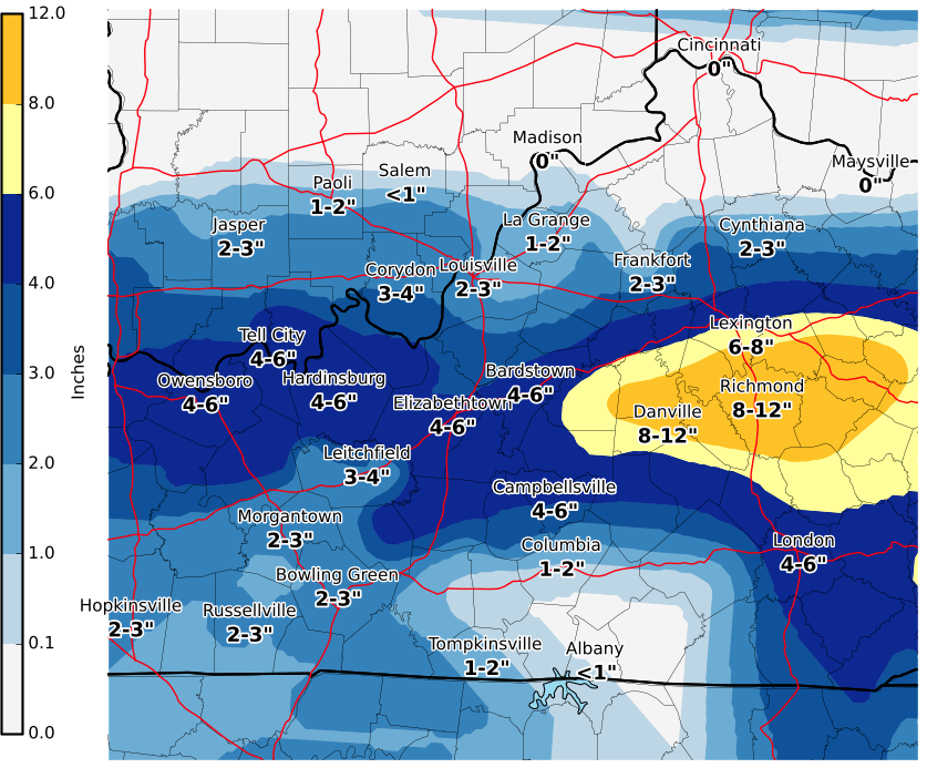
Sunday night into Monday morning, a real snow storm hit central Kentucky.  Some snowfall totals approached one foot of heavy, wet snow!
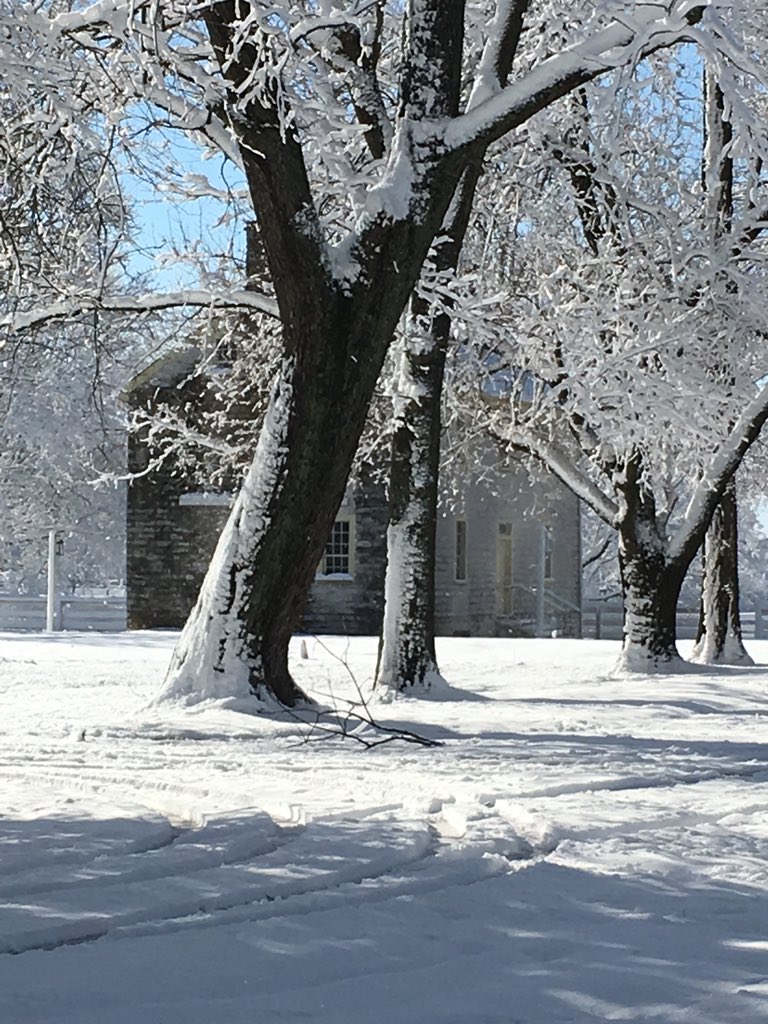
Shaker Villiage, KY Monday morning southwest of Lexington (from Twitter)
..SELECTED STORM TOTAL SNOWFALL IN INCHES FROM 700 AM EDT SUN MAR
11 THROUGH 1000 AM EDT MON MAR 12...

...KENTUCKY...
LEXINGTON 3 SSE                      10.5                    
BEREA                                10.0                    
KEENE 5 NE                            9.0                    
PAINT LICK                            9.0                    
STANTON 4 ESE                         8.5                    
CLOVER BOTTOM 1 WSW                   8.0                    
WINCHESTER 6.4 SE                     8.0                    
RICHMOND 4 E                          7.0                    
YELLOW ROCK                           7.0
A major noreaster is headed for New England, and the snow machine will be cranking up in the Sierra Nevada of California.
No automatic alt text available.

Another Winter Storm For Kentucky, the Central Appalachians, then New England

For those traveling south from Cincinnati, winter storm warnings and winter weather advisories have been hoisted for later tonight and Monday for as much as a half foot of heavy, wet snow in spots.
Southern Florida NE Gulf N of 25N E of 87W Gulf from 22N to 25N E of 87W including Straits of Florida NW Gulf including Stetson Bank N Central Gulf including Flower Garden Banks Marine Sanctuary W Central Gulf from 22N to 26N W of 94W Central Gulf from 22N to 26N between 87W and 94W Atlantic from 27N to 31N W of 77W Atlantic from 27N to 31N between 70W and 77W Atlantic from 27N to 31N between 65W and 70W Bahamas N of 22N including the Cay Sal Bank Atlantic from 22N to 27N E of Bahamas to 70W Tropical N Atlantic from 15N to 19N between 55W and 60W Caribbean N of 18N between 76W and 85W including the Cayman Basin Caribbean N of 18N between 76W and 85W including the Cayman Basin Caribbean approaches to the Windward Passage Atlantic S of 22N W of 70W including approaches to the Windward Passage Newport/Morehead City, NC Brownsville, TX Corpus Christi, TX Houston/Galveston, TX New Orleans, LA Lake Charles, LA Mobile, AL Tallahassee, FL Tampa, FL Miami, FL Key West, FL Florida Keys Miami, FL Melbourne, FL Jacksonville, FL Charleston, SC Wilmington, NC Baltimore/Washington, DC Wakefield, VA Philadelphia/Mt. Holly, PA/NJ New York, NY Boston, MA Gray/Portland, ME Intra Coastal Waters from Schoodic Point ME to Stonington ME Coastal Waters from Schoodic Point ME to Stonington ME out 25 NM Waters from Eastport ME to Stonington ME from 25 to 40 NM Northeast Minnesota and Northern Wisconsin Northern Michigan Northern Michigan Northern Michigan East Central Wisconsin - Green Bay East Central Wisconsin - Green Bay Southern and Southeastern Wisconsin Northeastern Illinois and Northwestern Indiana - Chicago Northern Indiana and Northwestern Ohio Southwestern Michigan Northeast Michigan - Gaylord Northeast Michigan - Gaylord Northeast Michigan - Gaylord Southeastern Michigan - Detroit Southeastern Michigan - Detroit Southeastern Michigan - Detroit Northern Ohio Western New York - Buffalo Western New York - Buffalo Northern Michigan Los Angeles, CA San Diego, CA San Francisco Bay Area/Monterey, CA Eureka, CA Medford, OR Portland, OR Seattle, WA Los Angeles Area Los Angeles Area Los Angeles Area Los Angeles Area Los Angeles Area Los Angeles Area South Central California San Francisco Area Western Nevada North Central California Northwest California Coast Southwest Oregon and Northern California Northeast Oregon and Southeast Washington Northwest Oregon Northwest Washington Eastern Washington and Northern Idaho Southern Nevada, Southeastern California and Northwestern Arizona - Las Vegas Southwestern California - San Diego Central Arizona and California Deserts Southeast Arizona Northern Arizona Utah Northern and Northeastern Nevada Southwestern Idaho and Eastern Oregon Southeastern Idaho Western Montana and Central Idaho Central Montana - Great Falls Northeastern Montana Southeastern Montana Western Wyoming Southeastern Wyoming and Western Nebraska Northeastern Colorado Western Colorado and Eastern Utah Southeastern Colorado Northern and Central New Mexico Southern New Mexico and extreme Western Texas - El Paso Texas and Oklahoma Lubbock and South Plains Texas Western Texas and Southeastern New Mexico Western South Dakota and Northeastern Wyoming Northwestern Kansas and East Central Colorado - Goodland Central Nebraska - North Platte North Central Kansas and South Central Nebraska Southeastern South Dakota, Southwestern Minnesota, and Northwestern Iowa Northern and Northeastern South Dakota Western North Dakota Eastern Nebraska and Southwestern Iowa - Omaha Valley Northeastern Kansas Southeastern Kansas Southwestern Kansas - Dodge City Central Oklahoma Eastern Oklahoma and Northwestern Arkansas Dallas and Fort Worth Central Texas - San Angelo Austin and San Antonio Texas Corpus Christi, Victoria, and Laredo Texas Southern Texas Texas - Houston/Galveston Southeast Texas and Southwest Louisiana Northern Louisiana and Eastern Texas - Shreveport Arkansas Southwestern Missouri Northwestern Missouri Central Iowa Southern Minnesota Northeastern North Dakota and Northwestern Minnesota Northeast Minnesota and Northern Wisconsin Southwestern Wisconsin, Southeastern Minnesota, and Northeast Iowa Eastern Iowa and Northwestern Illinois - Quad Cities Eastern Missouri - West Central Illinois Western Tennessee, Eastern Arkansas and Northern Mississippi - Memphis Central Mississippi Southeastern Louisiana Middle Tennessee Northern Alabama Central Alabama Mobile - Pensacola West Central Florida East Central Florida Panhandle of Florida and Southwestern Georgia Northeast Florida and Southeast Georgia Northern and Central Georgia Low Country of South Carolina and Georgia Northeastern South Carolina and Southeastern North Carolina - Wilmington Central South Carolina and CSRA Western North Carolina and Northwest South Carolina Eastern Tennessee Eastern Kentucky Central Kentucky Southern Illinois and Indiana, Southeastern Missouri and Western Kentucky Central and East Central Illinois Central Indiana Northeastern Illinois and Northwestern Indiana - Chicago Southern and Southeastern Wisconsin East Central Wisconsin - Green Bay Northern Michigan Northeast Michigan - Gaylord Northeast Michigan - Gaylord Southeastern Michigan - Detroit Southwestern Michigan Northern Indiana and Northwestern Ohio Southwestern Ohio Northern Kentucky West Virginia Western Virginia, Southeast West Virginia, and Northwest North Carolina Central North Carolina - Raleigh Eastern North Carolina Eastern Virginia, Southern Maryland and Northeast North Carolina Washington D.C., Central Maryland, Northern Virginia, Eastern West Virginia Western Pennsylvania, East Central Ohio and Extreme Western Maryland Northern Ohio Central Pennsylvania New Jersey, Delaware, and Southeastern Pennsylvania New York City and Surrounding Areas South Central New York and Northeastern Pennsylvania Western New York - Buffalo Eastern New York and Western New England Areas Boston and Surrounding Areas Northern Vermont and New York Southern Maine and New Hampshire Northern Maine Gulf of Maine to the Hague Line Georges Bank between Cape Cod and 68W north of 1000 fathoms South of New England between the Great South Channel and Montauk Point to 1000 fathoms South of Long Island between Montauk Point and Sandy Hook to 1000 fathoms Hudson Canyon to Baltimore Canyon to 1000 fathoms Baltimore Canyon to Cape Charles Light to 100 NM offshore Cape Charles Light to Currituck Beach Light to 100 NM offshore Currituck Beach Light to Cape Hatteras to 100 NM offshore Cape Hatteras to Cape Fear to 100 NM offshore Cape Fear to 31N to 1000 FM Georges Bank between 68W and the Hague Line East of 69W to the Hague Line between 1000 fathoms and 39N East of 69W and south of 39N to 250 NM offshore Between 1000 fathoms and 38.5N west of 69W Baltimore Canyon to 69W east of 1000 fathoms and south of 38.5N to 250 NM offshore Baltimore Canyon to Hatteras Canyon between 100 NM and 250 NM offshore Hatteras Canyon to Cape Fear 100 NM and 250 NM offshore Cape Fear to 31N east of 1000 fathoms to 250 NM offshore Cape Flattery to Cape Shoalwater between 60 NM and 150 NM offshore Cape Shoalwater to Cape Lookout between 60 NM and 150 NM offshore Cape Lookout to Florence, OR between 60 NM and 150 NM offshore Florence, OR to Point St. George between 60 NM and 150 NM offshore Point St. George to Point Arena between 60 NM and 150 NM offshore Point Arena to Pigeon Point between 60 NM and 150 NM offshore Pigeon Point to Point Piedras Blancas between 60 NM and 150 NM offshore Point Piedras Blancas to Santa Cruz Island, CA between 60 NM and 150 NM offshore Santa Cruz Island, CA to San Clemente Island, CA between 60 NM and 150 NM offshore Cape Flattery to Cape Shoalwater between 150 NM and 250 NM offshore Cape Shoalwater to Cape Lookout between 150 NM and 250 NM offshore Cape Lookout to Florence, OR between 150 NM and 250 NM offshore Florence, OR to Point St. George between 150 NM and 250 NM offshore Point St. George to Point Arena between 150 NM and 250 NM offshore Point Arena to Pigeon Point between 150 NM and 250 NM offshore Pigeon Point to Point Piedras Blancas between 150 NM and 250 NM offshore Point Piedras Blancas to Santa Cruz Island, CA between 150 NM and 250 NM offshore Santa Cruz Island, CA to 120W between 150 NM and 250 NM offshore San Clemente Island, CA to Guadalupe Island from 60 NM Offshore west to 120W Juneau, AK Fairbanks, AK Anchorage, AK Western US Arctic Offshore Eastern US Arctic Offshore Bering Sea offshore 171 degrees West to 180 degrees and north of 56 degrees North Bering Sea offshore 171 degrees West to 180 degrees and south of 56 degrees North Pribilof Islands (St. Paul and St. George) Bering Sea offshore east of 171 degrees West Gulf of Alaska offshore north of 57 degrees North and west of 144 degrees West Gulf of Alaska offshore south of 57 degrees North north of 55 degrees North and west of 144 degrees West Gulf of Alaska north of 55 degrees North and east of 144 degrees West Juneau, AK Honolulu, HI Hawaiian Offshore Waters

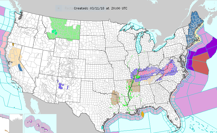
Winter Storm Warnings are in effect for parts of the Central/Southern Appalachians and Kentucky for Sunday into Monday. A new low will form off the Southeast Coast by Monday morning and bring a multitude of hazards to the Mid-Atlantic and New England through Tuesday, including snow, minor coastal flooding and the potential for strong winds.

Rain will change over to wet snow across southern Indiana and central Kentucky this evening, becoming heavy wet snow at times overnight. Accumulations of 3 to 6 inches are expected across central Kentucky with localized higher amounts possible. Across far southern Kentucky, north central Kentucky and portions of southern Indiana, 1 to 4 inches are expected.

Cold temperatures will prevail through the middle of the week, slowing down spring blooms and bringing the chance for a little snow in Cincinnati Tuesday night.

After that, the weather pattern will begin moderating in the eastern US with wet weather returning by next weekend.
Soil Moisture Condition Monitoring Weekly Report

Station Number: OH-HM-24
Station Name: Cheviot 3.4 W
Report Date: 3/10/2018
Submitted: 3/10/2018 6:26 AM
Scale Bar: Moderately Wet
Description:
Only 0.06 inch of liquid (mostly melted snow) in the past week. With cold temperatures, we are only slowly drying from the severely wet conditions of a week ago. Rivers are below flood stage, standing water has dried up some but soils are still wet and swales are still very wet or holding water.Categories: General Awareness
Agriculture
Plants & Wildlife

This report is specifically for the Arbor Doctor’s location 3.4 miles west of Cheviot, OH, in the western suburbs of Cincinnati in southwest Ohio. This location is also an official cooperative observation site for the National Weather Service listed as Cheviot 3W.

What is the Condition Monitoring Report? See these links for more information:

https://www.cocorahs.org/Content.aspx?page=cm-scalebar

Search condition monitoring reports for the entire US>>>