Thursday Morning’s Wintry Mess Was Foreseen…to an extent

Warnings Need To Be Better And More Clear

Thursday morning saw a mess of slippery roads and snow squalls in Cincinnati resulting in numerous accidents. There was not much snow, mostly a half inch or less with only a few hundreths of an inch of liquid. A summary of the event can be found at this link: https://www.weather.gov/iln/20180308

I have seen such conditions over the years. They are hard to predict and create some of the worst winter driving conditions we ever encounter. The night before, I sent out the following text to two of my employees at 8:11 PM: “The National Weather Service has put out a statement for the possibility of scattered snow amounts up to an inch tonight so you might want to be prepared to go out in the morning and put some salt down if need be. Just a possibility at this point especially with the warm ground temperatures.”

Unfortunately, probably the worst case scenario for roads is warm ground temperatures with a quick burst of snow when air temperatures are a few degrees below freezing. Snow initially melts on contact then re-freezes creating exactly the conditions we saw Thursday morning.

Such snow squalls can be rather localized and hard to predict and pinpoint. There was not a general, widespread snow that morning, but it did manage to rake across much of the metro area.  The snow squalls were predicted. Such squalls glaze roads so quickly that it is impossible for road crews to get out ahead of them. Salt will quickly blow off roads. Bad roads and accidents are inevitable when timing coincides with rush hour. It is nobody’s fault.

The National Weather Service began trialing snow squall warnings this year in limited markets. I have suggested such warnings for years and would suggest the roll out be expedited. It is the current practice of the National Weather Service to issue a Hazardous Weather Outlook when such conditions are foreseen. Unfortunately, this outlook is not widely disseminated and few even know it exists.

Considering the potential impact of this type of condition, more direct warnings and advisories would be a very good idea.

STORM SUMMARY NUMBER 7 FOR MID-ATLANTIC TO NORTHEAST WINTER STORM

NWS WEATHER PREDICTION CENTER COLLEGE PARK MD
400 PM EST THU MAR 08 2018

...MODERATE TO HEAVY SNOW CONTINUES FOR NORTHERN NEW YORK AND
NORTHERN NEW ENGLAND... 

WINTER STORM WARNINGS AND WINTER WEATHER ADVISORIES ARE IN EFFECT
FOR NORTHERN NEW YORK AND NORTHERN NEW ENGLAND...AS WELL AS
PORTIONS OF THE GREAT LAKES REGION AND THE CENTRAL APPALACHIANS.

FOR A DETAILED GRAPHICAL DEPICTION OF THE LATEST
WATCHES...WARNINGS AND ADVISORIES...PLEASE SEE WWW.WEATHER.GOV

AT 300 PM EST...THE CENTER OF A LOW PRESSURE SYSTEM WITH AN
ESTIMATED CENTRAL PRESSURE OF 988 MB...29.18 INCHES...WAS LOCATED
ABOUT 80 MILES SOUTH-SOUTHEAST OF BANGOR...MAINE. SURFACE
OBSERVATIONS AND NATIONAL WEATHER SERVICE DOPPLER RADARS INDICATED
MODERATE TO HEAVY SNOW WAS FALLING IN NORTHERN NEW YORK AND
NORTHERN PORTIONS OF NEW ENGLAND...WITH THE HEAVIEST SNOW FALLING
ACROSS MAINE. IN ADDITION...LIGHT TO MODERATE SNOW WAS FALLING
ACROSS PARTS OF THE GREAT LAKES REGION...WITH SNOW SHOWERS IN THE
CENTRAL APPALACHIANS AS WELL.  

...SELECTED STORM TOTAL SNOWFALL IN INCHES FROM 700 PM EST TUE MAR
06 THROUGH 300 PM EST THU MAR 08...

...MASSACHUSETTS...
CLARKSBURG                           32.0                    
CHESHIRE                             31.0                    
NORTH ADAMS                          30.0                    
BECKET 5.6 SSW                       23.3                    
PEPPERELL                            20.0                    
STERLING                             17.8                    
WESTBOROUGH                          16.9                    
WORCESTER                            16.2                    
CLINTON                              16.0                    
HEATH                                16.0                    
SHIRLEY                              16.0                    
BOSTON LOGAN ARPT                     5.9                    

...MAINE...
SANFORD                              19.0                    
SANDY BROOK 2 ESE                    17.1                    
HARTFORD                             16.5                    
SACO                                 16.0                    
WOOLWICH                             16.0                    
MILLBRIDGE 2 NNW                     15.0                    
ROCKLAND                             14.5                    
BAR HARBOR                           14.0                    
GREENE 4.5 NNW                       14.0                    
PORTLAND JETPORT                     14.0                    
STARKS                               14.0                    
TURNER 3 E                           14.0                    

...NEW HAMPSHIRE...
MADISON 1 N                          18.0                    
SUNAPEE                              18.0                    
DOVER                                17.7                    
GONIC                                17.2                    
DERRY                                16.5                    
LONDONDERRY                          16.0                    
MERRIMACK 3 NNW                      15.8                    
WEST HAMPSTEAD                       15.6                    
BROOKLINE 2.1 SW                     15.5                    
CHESTER 1 NW                         15.5                    
AUBURN 1.8 E                         15.3                    
ROLLINSFORD 2.0 WSW                  15.0                    

...NEW YORK...
MONROE                               26.0                    
SLOATSBURG                           26.0                    
HILLSDALE 4 N                        24.5                    
HIGHLAND MILLS                       24.3                    
AUSTERLITZ                           21.5                    
HIGHLAND                             21.0                    
TAGHKANIC                            20.3                    
ORANGE LAKE                          20.1                    
PETERSBURG                           20.0                    
CHESTNUT RIDGE                       19.5                    
PHILMONT 5 E                         19.3                    
MAHOPAC                              18.8                    
CENTRAL PARK                          3.2                    
NYC/JFK AIRPORT                       2.8                    
NYC/LA GUARDIA AIRPORT                1.7                    

...VERMONT...
WOODFORD                             36.0                    
SEARSBURG                            32.5                    
LONDONDERRY                          30.0                    
WEST DOVER 2 NNE                     30.0                    
PERU                                 28.0                    
WILMINGTON 0.6 WNW                   27.0                    
LANDGROVE                            26.5                    
WARDSBORO 2.6 SW                     26.4                    
BELMONT                              26.0                    
WESTON 1 WNW                         25.0                    

...SELECTED PEAK WIND GUSTS IN MILES PER HOUR EARLIER IN THE
EVENT...

...MASSACHUSETTS...
MASHAPEE                              59                    
HYANNIS 1 SE                          56                    
PLYMOUTH 7 N                          55                    
WESTERLY                              54                    
MARSTONS MILLS                        53                    
NANTUCKET                             52                    
BOSTON - LOGAN AIRPORT                51                    
ROCKPORT                              51                    
EDGARTOWN                             49                    
WESTPORT                              48                    
BOSTON                                46                    
EAST FALMOUTH                         46                    
WESTFIELD - BARNES                    45                    

...SELECTED STORM TOTAL SNOWFALL IN INCHES WHERE THE EVENT HAS
ENDED...

...CONNECTICUT...
WARREN                               28.0                    
NEW FAIRFIELD                        26.8                    
CORNWALL BRIDGE 4 SSW                25.5                    
NEWTOWN                              24.3                    
SHARON                               23.0                    
RIDGEFIELD                           19.0                    
WOLCOTT                              18.5                    
GERMANTOWN                           16.5                    
SOUTHINGTON                          16.5                    
NORTHFORD                            15.7                    
NEW HARTFORD CENTER 3.2 SW           12.3                    

...DELAWARE...
GREENVILLE                           10.4                    
BRANDYWINE                           10.0                    
HOCKESSIN                            10.0                    
NORTH WILMINGTON                      8.0                    
SMITH MILL FARMS                      7.6                    
TALLEY BROOK                          6.9                    
EDGEMOOR                              6.0                    
NEW CASTLE COUNTY AIRPORT             6.0                    
PRICES CORNER                         5.7                    
NEWARK                                5.6                    
BLACKBIRD                             4.2                    
CLAYMONT                              4.2                    
GLASGOW                               4.0                    
SMYRNA                                2.7                    
BEAR                                  2.0                    

...MARYLAND...
RISING SUN                            5.5                    
BELAIR                                4.5                    
CHURCHVILLE                           4.5                    
LONG GREEN                            4.0                    
TOWSON                                3.7                    
TOWSON 0.8 SW                         3.7                    
BEL AIR 1.7 W                         3.0                    
MILLINGTON                            3.0                    
ELKTON 4.8 NW                         2.5                    
KINGSVILLE 1.2 E                      2.4                    
ANNAPOLIS 1 NW                        2.0                    
BOWIE 3.9 S                           2.0                    
MARYDEL                               2.0                    
SUITLAND 2.1 SE                       2.0                    
BALTIMORE-WASHINGTON INTL ARPT        1.8                    
CROFTON 1 SSE                         1.5                    

...NEW JERSEY...
KINNELON 1.4 SE                      31.0                    
MONTVILLE                            26.8                    
MORRIS PLAINS                        26.0                    
OAKLAND 0.9 SSE                      26.0                    
BUTLER                               25.5                    
KINNELON                             25.0                    
PINE BROOK                           24.5                    
FRANKLIN LAKES                       24.0                    
GREEN POND                           24.0                    
NORTH CALDWELL                       23.0                    
WARREN TWP                           23.0                    
NEWARK AIRPORT                        4.6                    
ATLANTIC CITY INTL ARPT               2.5                    

...PENNSYLVANIA...
RICHBORO                             16.0                    
ROSEMONT                             14.3                    
MONTGOMERVILLE                       13.5                    
WRIGHTSTOWN TWP                      13.5                    
NEWTOWN GRANT                        13.2                    
WICKERTON 0.4 NW                     13.0                    
BOSSARDSVILLE                        12.4                    
BEDMINSTER                           12.0                    
BROOMHALL                            12.0                    
PHILADELHIA INTL AIRPORT              6.1                    

...RHODE ISLAND...
BURRILLVILLE                         13.0                    
NORTH FOSTER                         11.3                    
NORTH SMITHFIELD                      8.8                    
GREENVILLE 0.7 NNW                    7.8                    
WOONSOCKET                            7.0                    
NORTH PROVIDENCE                      6.5                    
GREENE                                6.0                    
WEST WARWICK                          5.0                    

...VIRGINIA...
FALLS CHURCH 1.6 W                    0.9                    
RONALD REAGAN NATIONAL ARPT           0.4                    


THE SURFACE LOW WILL START TO SLOWLY WEAKEN AS IT DRIFTS NORTH AND
WEST ACROSS MAINE ON THURSDAY NIGHT AND INTO SOUTHERN QUEBEC ON
FRIDAY. AS THE LOW LINGERS...SNOW WILL CONTINUE THROUGH FRIDAY AND
SATURDAY FOR NORTHERN MAINE...WITH AN ADDITIONAL 8 TO 12 INCHES
POSSIBLE. MEANWHILE...THE WEAKENING LOW PRESSURE SYSTEM OVER THE
LOWER GREAT LAKES PLUS LAKE ENHANCEMENT OF THE SNOW WILL BRING 6
TO 10 INCHES OF SNOW TO PORTIONS OF THE LOWER GREAT LAKES. 2 TO 6
INCHES OF SNOW IS FORECAST FOR PORTIONS OF THE CENTRAL
APPALACHIANS.

THE NEXT STORM SUMMARY WILL BE ISSUED BY THE WEATHER PREDICTION
CENTER AT 1000 PM EST. PLEASE REFER TO YOUR LOCAL NATIONAL WEATHER
SERVICE OFFICE FOR ADDITIONAL INFORMATION ON THIS EVENT.

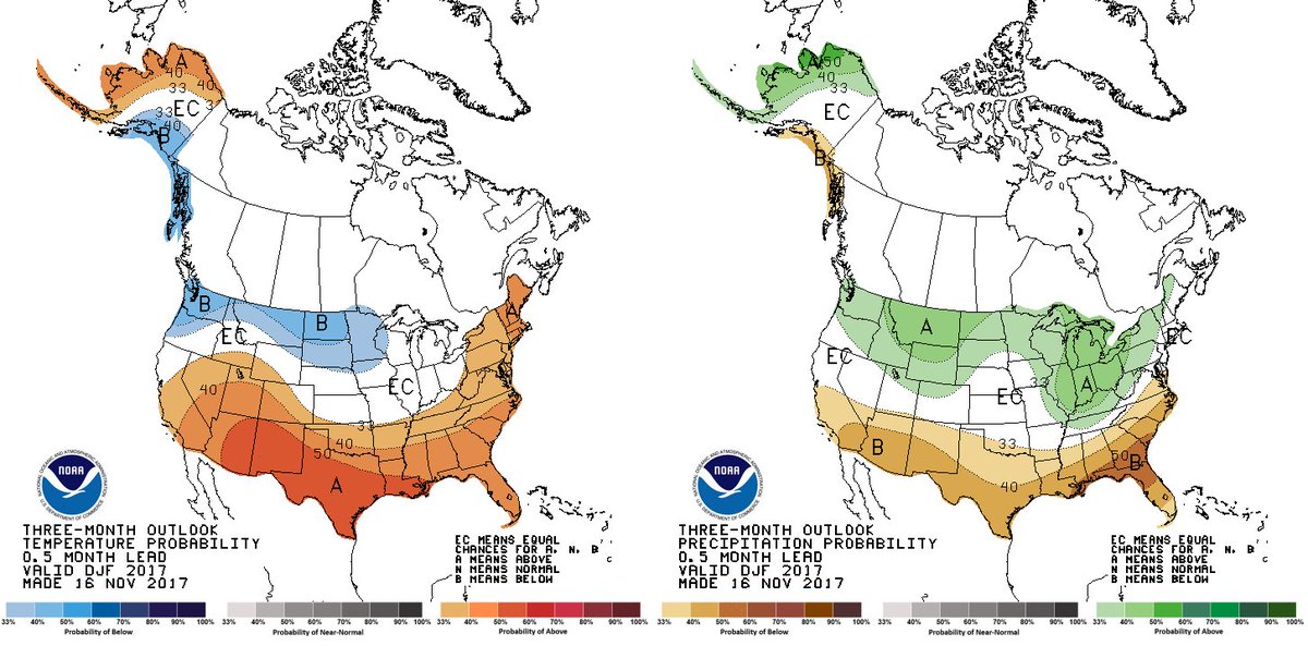
Winter 2017-2018

(This article was posted in December and is being kept up to see how we’re doing. As of early February, the beginning of the last month of meteorological winter, the temperature forecast is close, but with colder temperatures in the northeast. The precipitation forecast has not been as good. Yes, it has been dry in the south but the above normal precipitation in the Ohio valley is not verifying,)

Ready for ? Here is our latest and final DJF 2017-18 forecast. There are some subtle changes from previous months, but still heavily influenced by . Learn more…