A strong storm system is spreading precipitation across the area
this morning. Rain mixing with brief periods of freezing rain or
sleet is expected near and just to the south of the I-70 corridor
through the early evening, which may initially hold down snow
totals from east-central Indiana through parts of central Ohio.
Periods of snow north of I-70 will lead to accumulations through
this evening, with all rain during this period near and south of
the Ohio River.
By this evening, temperatures will plummet as an arctic cold
front sweeps through the area. There will be a sharp transition
from northwest to southeast of rain or freezing rain to snow with
very strong northwesterly winds for the overnight hours. Expect
winds of 20 to 30 mph tonight with wind gusts up to 45 mph to
overspread the entire area. Snow is expected to increase in
intensity with some locations observing near blizzard conditions
late this evening into the early overnight period. Travel
conditions, especially near and north of the I-71 corridor, will
quickly deteriorate late this evening, becoming hazardous and
potentially dangerous. Flash freeze will be possible on some
roads, with blowing and drifting snow causing brief whiteout
conditions late this evening through the early overnight period.
Snow is expected to diminish in coverage and intensity towards
daybreak Sunday. Wind chills will fall to the single digits below
zero and above zero by Sunday morning.
Try to avoid going outdoors late this evening through early
Sunday morning due to bitterly cold temperatures and hazardous
road conditions.
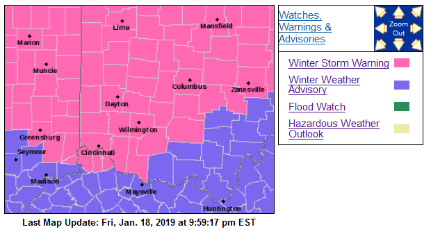
Ripley-Dearborn-Ohio-Boone-Kenton-Campbell-Ross-Hamilton-Clermont-
Brown-Highland-
Including the cities of Batesville, Milan, Versailles,
Lawrenceburg, Aurora, Rising Sun, Florence, Burlington, Oakbrook,
Covington, Erlanger, Independence, Newport, Alexandria,
Chillicothe, Cincinnati, Milford, Georgetown, Mount Orab,
Hillsboro, and Greenfield
352 AM EST Sat Jan 19 2019
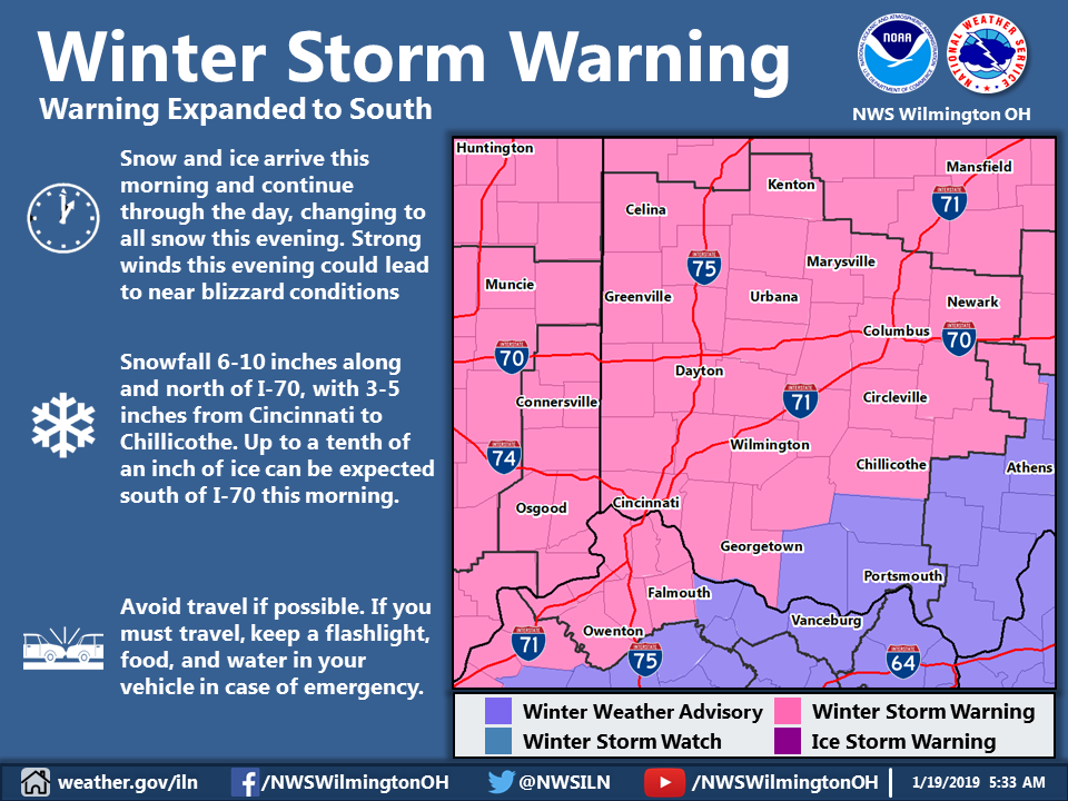
…WINTER STORM WARNING REMAINS IN EFFECT FROM 2 PM THIS
AFTERNOON TO 8 AM EST SUNDAY…
* WHAT…Heavy mixed precipitation expected. Total snow
accumulations of 3 to 5 inches and ice accumulations of around
one tenth of an inch expected. Winds gusting as high as 45 mph.
* WHERE…Portions of Southeast Indiana, Northern Kentucky and
South Central and Southwest Ohio.
* WHEN…From 2 PM this afternoon to 8 AM EST Sunday.
* ADDITIONAL DETAILS…Travel could be very difficult.
Widespread blowing snow could significantly reduce visibility.
PRECAUTIONARY/PREPAREDNESS ACTIONS…
A Winter Storm Warning means significant amounts of snow, sleet
and ice will make travel very hazardous or impossible.
Wayne-Darke-Shelby-Logan-Union OH-Delaware-Miami-Champaign-Clark-
Madison-Franklin OH-Licking-
Including the cities of Richmond, Greenville, Sidney,
Bellefontaine, Marysville, Delaware, Troy, Piqua, Tipp City,
Urbana, Springfield, London, West Jefferson, Plain City,
Columbus, and Newark
352 AM EST Sat Jan 19 2019
…WINTER STORM WARNING REMAINS IN EFFECT UNTIL 4 AM EST SUNDAY…
* WHAT…Heavy mixed precipitation expected. Total snow
accumulations of 6 to 8 inches and ice accumulations of a light
glaze expected. Winds gusting as high as 45 mph.
* WHERE…Portions of East Central Indiana and Central and West
Central Ohio.
* WHEN…Until 4 AM EST Sunday.
* ADDITIONAL DETAILS…Travel could be very difficult to
impossible. Widespread blowing snow could significantly reduce
visibility.
PRECAUTIONARY/PREPAREDNESS ACTIONS…
A Winter Storm Warning means significant amounts of snow, sleet
and ice will make travel very hazardous or impossible.