
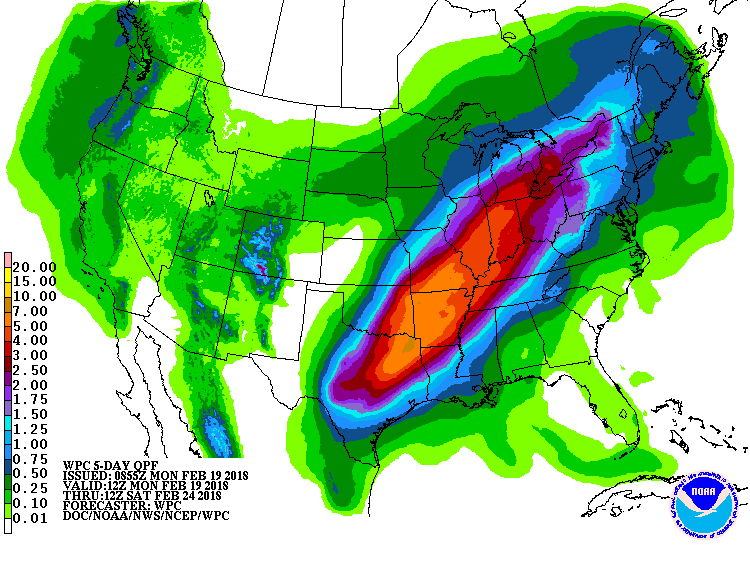
A strong southwest to northeast flow of warm, moist air between a very warm southeast US high pressure ridge and a western US trough will efficiently guide round after round of moisture up the Mississippi and Ohio River valleys. The Ohio River is already forecast to go well over flood stage and continued heavy rainfall will only exacerbate the flooding. We are likely entering a period of significant, long term flooding and accelerated spring warm up and green up. In addition to the heavy rain and flooding, growing degree accumulation will accelerate and an early spring will accelerate.
Growing Degree Day Accumulation: 
Rainfall through Monday Feb. 26, 2018

Flood Warning
Flood Warning
National Weather Service Wilmington OH
1009 AM EST Mon Feb 19 2018

...Forecast flooding changed from Minor to Moderate severity for the
following rivers...

  Ohio River at Cincinnati

PRECAUTIONARY/PREPAREDNESS ACTIONS...

Safety message...Do not drive your car through flooded roadways. The
water depth may be deeper than it appears.


Stay tuned to developments by listening to NOAA Weather All Hazards
radio. For additional details on river forecasts, visit
water.weather.gov/ahps2/index.php?wfo=iln

&&

INC029-115-KYC015-037-117-OHC025-061-200309-
/O.EXT.KILN.FL.W.0012.000000T0000Z-180224T0600Z/
/CCNO1.2.ER.180218T2154Z.180221T0600Z.180224T0000Z.NO/
1009 AM EST Mon Feb 19 2018

...Forecast flooding has increased from Minor to Moderate severity...
The Flood Warning continues for
 The Ohio River at Cincinnati

* until late Friday night.
* At 9 AM the stage was 53.6 feet.
* Flood stage is 52 feet.
* Minor flooding is occurring and Moderate flooding is forecast.
* The river will continue rising to just above 56 feet by early Wednesday
  morning.The river will fall below flood stage Friday evening.
* At stages near 56 feet, Widespread backwater flooding along creeks
  and streams occurs, with Route 8 in Kentucky, Route 56 in Indiana and
  both Route 52 and old Route 52 flooded in areas. Backwater flooding
  also affects Anderson Township, flooding numerous roads and basements.
  Locations most affected include low-lying areas near New Richmond, the
  East End, California and Anderson and Pierce Townships.


&&

LAT...LON 3890 8418 3885 8429 3903 8449 3903 8494
      3916 8490 3914 8437

$$
Hazardous Weather Outlook
Hazardous Weather Outlook
National Weather Service Wilmington OH
459 AM EST Mon Feb 19 2018

INZ074-075-080-KYZ089>100-OHZ077>079-081-088-201000-
Dearborn-Ohio-Switzerland-Carroll-Gallatin-Boone-Kenton-Campbell-
Owen-Grant-Pendleton-Bracken-Robertson-Mason-Lewis-Hamilton-Clermont-
Brown-Adams-Scioto-
459 AM EST Mon Feb 19 2018

This Hazardous Weather Outlook is for Southeast Indiana, Northeast
Kentucky, Northern Kentucky, South Central Ohio and Southwest Ohio.

.DAY ONE...Today and Tonight.

Some river flooding will persist. Please check our web site at
www.weather.gov/iln for more information on the river flooding.

.DAYS TWO THROUGH SEVEN...Tuesday through Sunday.

Several rounds of enhanced rainfall will occur through the week. This
will lead to rises on area creeks and streams, along with the
potential for flooding, including at locations along the Ohio River.

.SPOTTER INFORMATION STATEMENT...

Spotters are asked to report rainfall totals and flooding to the
National Weather Service.