
Do Not Travel Tonight In Cincinnati Area. Many roads are flooded and dangerous areas of standing water. As of 8:40 PM, huge amount of rain on radar still to move through.


| 58 | Numerous homes and businesses are either surrounded by water, water in basements or on main levels. Backwater flooding occurs along the Little Miami flooding low lying streets and properties. East End, California, New Richmond, Bromley, Ludlow, and Aurora and areas near Lawrenceburg outside the floodwall are most impacted. Buildings at Coney Island flood. The area around Freeman Avenue and along Mehring Way floods, as well as between Gest and Elm on Pete Rose Way. |
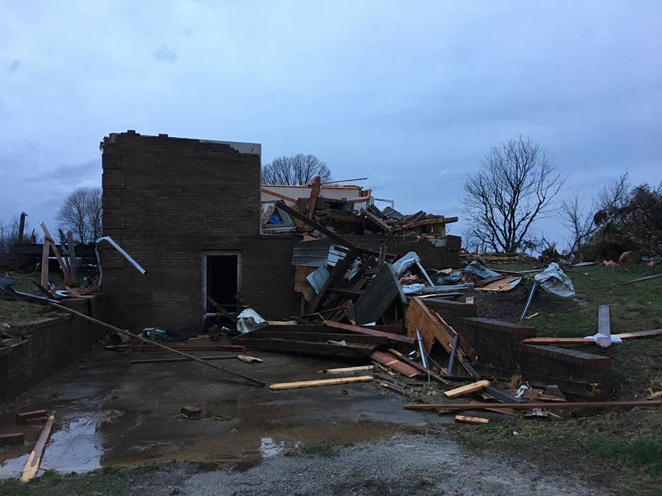
The first #tornado related deaths in the US since May 16th, 2017 tonight in Logan County, Kentucky. 283 days since the last #tornadodeath, a record. Photo from News Democrat & Leader:
BULLETIN - EAS ACTIVATION REQUESTED
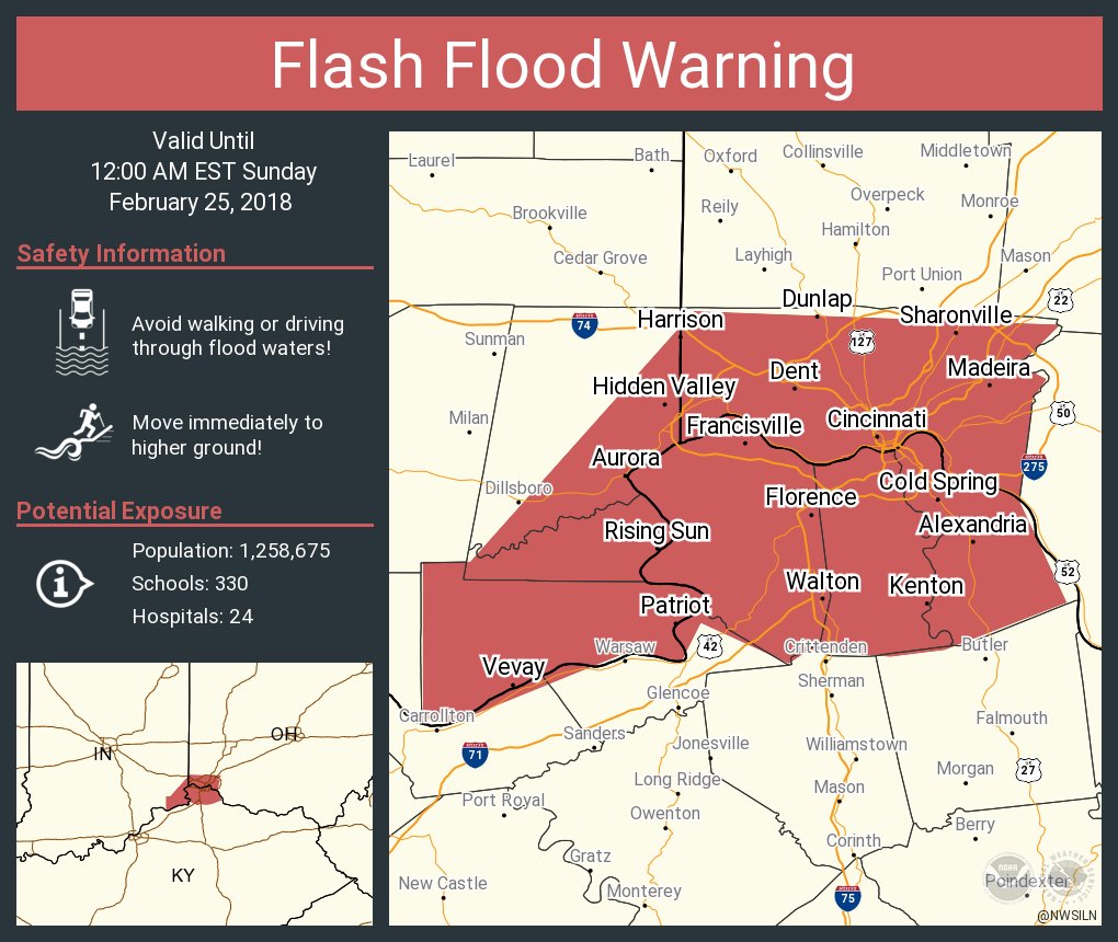
Flash Flood Warning
National Weather Service Wilmington OH
836 PM EST SAT FEB 24 2018
The National Weather Service in Wilmington has issued a
* Flash Flood Warning for...
Bracken County in northern Kentucky...
Pendleton County in northern Kentucky...
Clermont County in southwestern Ohio...
Brown County in southwestern Ohio...
* Until 130 AM EST.
* At 835 PM EST, radar indicated that heavy rain had fallen across
the warned area. Up to one inch of rain has already fallen. Heavy
rain continues to fall with another 1 to 2 inches possible. Runoff
from this excessive rainfall will cause flash flooding to occur.
* Some locations that will experience flooding include...
Loveland, Milford, Georgetown, Falmouth, Amelia, Mount Orab,
Bethel, New Richmond, Williamsburg, Batavia, Augusta, Sardinia,
Felicity, Brooksville, Butler, Withamsville, Camp Dennison, Morgan,
Woodville and Owensville.
PRECAUTIONARY/PREPAREDNESS ACTIONS...
Move to higher ground now. Act quickly to protect your life.
To report flash flooding, go to our website at weather.gov/iln and
submit your report via social media, when you can do so safely.
&&
LAT...LON 3854 8447 3879 8453 3881 8440 3887 8423
3902 8432 3916 8430 3920 8428 3922 8432
3927 8426 3925 8387 3902 8387 3902 8375
3860 8399 3861 8408 3855 8414 3855 8421
3858 8421 3856 8441
$$
AR
Flash Flood Warning
INC029-115-155-KYC015-037-041-077-117-OHC061-250500-
/O.NEW.KILN.FF.W.0003.180225T0104Z-180225T0500Z/
/00000.0.ER.000000T0000Z.000000T0000Z.000000T0000Z.OO/

BULLETIN - EAS ACTIVATION REQUESTED
Flash Flood Warning
National Weather Service Wilmington OH
804 PM EST SAT FEB 24 2018

The National Weather Service in Wilmington has issued a

* Flash Flood Warning for...
  Ohio County in southeastern Indiana...
  Central Dearborn County in southeastern Indiana...
  Switzerland County in southeastern Indiana...
  Central Carroll County in northern Kentucky...
  Kenton County in northern Kentucky...
  Campbell County in northern Kentucky...
  Boone County in northern Kentucky...
  Gallatin County in northern Kentucky...
  Hamilton County in southwestern Ohio...

* Until midnight EST.

* At 801 PM EST, radar indicated that heavy rain was falling across
  the warned area. Heavy rain will continue to fall with another 1
  to 2 inches possible. This rainfall on very saturated ground will
  cause flash flooding to occur.

* Some locations that will experience flooding include...
  Cincinnati, Covington, Florence, Independence, Norwood, Forest
  Park, Erlanger, Fort Thomas, Newport, Sharonville, Blue Ash,
  Loveland, Springdale, Reading, Montgomery, Harrison, North College
  Hill, Madeira, Edgewood and Alexandria.

PRECAUTIONARY/PREPAREDNESS ACTIONS...

Move to higher ground now. Act quickly to protect your life.

To report flash flooding, go to our website at weather.gov/iln and
submit your report via social media, when you can do so safely.

&&

LAT...LON 3893 8520 3893 8513 3930 8480 3928 8426
      3922 8432 3920 8428 3917 8430 3902 8432
      3887 8425 3880 8443 3879 8451 3880 8463
      3878 8466 3884 8479 3878 8482 3880 8489
      3869 8516 3870 8520

$$

AR
Flash Flood Warning
KYC041-077-081-187-250315-
/O.NEW.KILN.FF.W.0002.180225T0024Z-180225T0315Z/
/00000.0.ER.000000T0000Z.000000T0000Z.000000T0000Z.OO/

BULLETIN - EAS ACTIVATION REQUESTED
Flash Flood Warning
National Weather Service Wilmington OH
724 PM EST SAT FEB 24 2018

The National Weather Service in Wilmington has issued a

* Flash Flood Warning for...
  Carroll County in northern Kentucky...
  Grant County in northern Kentucky...
  Owen County in northern Kentucky...
  Gallatin County in northern Kentucky...

* Until 1015 PM EST.

* At 718 PM EST, radar indicated that heavy rain was falling across
  the warned area. This rain will produce 1 to 1.5 inches. This
  excessive rainfall on very saturated ground will cause flash
  flooding to occur.

* Some locations that will experience flooding include...
  Carrollton, Williamstown, Crittenden, Dry Ridge, Warsaw, Owenton,
  Florence, Kentucky Speedway, Glencoe, Ghent, Sanders, Corinth,
  Sparta, Worthville, Prestonville, Monterey, Brooksburg, Gratz,
  Stewartsville and Elk Lake.

PRECAUTIONARY/PREPAREDNESS ACTIONS...

Move to higher ground now. Act quickly to protect your life.

To report flash flooding, go to our website at weather.gov/iln and
submit your report via social media, when you can do so safely.

&&

LAT...LON 3838 8490 3842 8488 3846 8492 3843 8496
      3852 8498 3851 8503 3856 8501 3860 8508
      3858 8521 3872 8532 3874 8526 3869 8517
      3880 8489 3878 8482 3884 8479 3878 8466
      3880 8463 3878 8454 3852 8448 3834 8479

$$

AR
Flash Flood Statement
National Weather Service Louisville KY
841 PM EST SAT FEB 24 2018

INC019-077-KYC103-185-223-250345-
/O.CON.KLMK.FF.W.0003.000000T0000Z-180225T0345Z/
/00000.0.ER.000000T0000Z.000000T0000Z.000000T0000Z.OO/
Jefferson IN-Clark IN-Oldham KY-Trimble KY-Henry KY-
841 PM EST SAT FEB 24 2018

...THE FLASH FLOOD WARNING REMAINS IN EFFECT UNTIL 1045 PM EST FOR
SOUTH CENTRAL JEFFERSON...NORTHEASTERN CLARK...OLDHAM...TRIMBLE AND
WESTERN HENRY COUNTIES...

At 837 PM EST, NWS Doppler radar indicated that most of the heavy
rain had moved out of the warned area for the time being, although a
few heavier showers remained. Nevertheless, some roads remain
flooded across the area.

National Weather Service employees reported 2.9 inches of rain in
Centerfield and 3.57 inches in Pewee Valley, both in Oldham County
since this morning.

Additional heavy rain, and likely additional flash flooding, will
occur later this evening as thunderstorms to the west move east into
the area.

PRECAUTIONARY/PREPAREDNESS ACTIONS...

Turn around, don`t drown when encountering flooded roads. Most flood
deaths occur in vehicles. Be especially cautious at night when it is
harder to recognize the dangers of flooding.

&&

LAT...LON 3877 8541 3871 8532 3863 8523 3862 8523
      3860 8521 3858 8521 3859 8510 3857 8507
      3830 8535 3831 8539 3831 8541 3829 8541
      3830 8542 3829 8543 3830 8545 3829 8546
      3841 8568

$$

TWF
Flash Flood Statement
National Weather Service Louisville KY
835 PM EST SAT FEB 24 2018

INC019-043-KYC029-111-250245-
/O.CON.KLMK.FF.W.0002.000000T0000Z-180225T0245Z/
/00000.0.ER.000000T0000Z.000000T0000Z.000000T0000Z.OO/
Clark IN-Floyd IN-Jefferson KY-Bullitt KY-
835 PM EST SAT FEB 24 2018

...THE FLASH FLOOD WARNING REMAINS IN EFFECT UNTIL 945 PM EST FOR
SOUTHWESTERN CLARK...FLOYD...JEFFERSON AND NORTHWESTERN BULLITT
COUNTIES...

At 830 PM EST, NWS Doppler radar indicated that heavy rain had ended
for the time being across the warned area. However, there have been
reports of water over roads, especially over parts of south-central
and eastern Jefferson County, Kentucky. Some creeks and small
streams are out of their banks.

Additional heavy rain, and likely additional flash flooding, will
occur in the warned area later this evening as a band of
thunderstorms moves in from the west.

PRECAUTIONARY/PREPAREDNESS ACTIONS...

Turn around, don`t drown when encountering flooded roads. Most flood
deaths occur in vehicles. Be especially cautious at night when it is
harder to recognize the dangers of flooding.

&&

LAT...LON 3840 8593 3841 8569 3835 8558 3834 8558
      3834 8556 3829 8547 3826 8541 3812 8543
      3798 8577 3794 8590 3799 8591 3800 8595
      3803 8592 3809 8591 3814 8591 3818 8590
      3842 8603

$$

TWF
Flash Flood Warning
INC019-025-043-061-117-123-143-175-KYC163-250630-
/O.NEW.KLMK.FF.W.0005.180225T0135Z-180225T0630Z/
/00000.0.ER.000000T0000Z.000000T0000Z.000000T0000Z.OO/

BULLETIN - EAS ACTIVATION REQUESTED
Flash Flood Warning
National Weather Service Louisville KY
835 PM EST SAT FEB 24 2018

The National Weather Service in Louisville has issued a

* Flash Flood Warning for...
  Harrison County in south central Indiana...
  Northwestern Clark County in south central Indiana...
  Crawford County in south central Indiana...
  Perry County in south central Indiana...
  Western Floyd County in south central Indiana...
  Eastern Orange County in south central Indiana...
  Scott County in south central Indiana...
  Washington County in south central Indiana...
  Meade County in central Kentucky...

* Until 130 AM EST/1230 AM CST/

* At 834 PM EST/734 PM CST/, Doppler radar indicated thunderstorms
  producing heavy rain across the warned area. Given already
  saturated soil conditions, flash flooding will begin shortly.

* Some locations that will experience flooding include...
  Tell City, Scottsburg, Salem, Corydon, Brandenburg, English, New
  Providence Town, Carefree Town, Mount Pleasant and Vienna.