

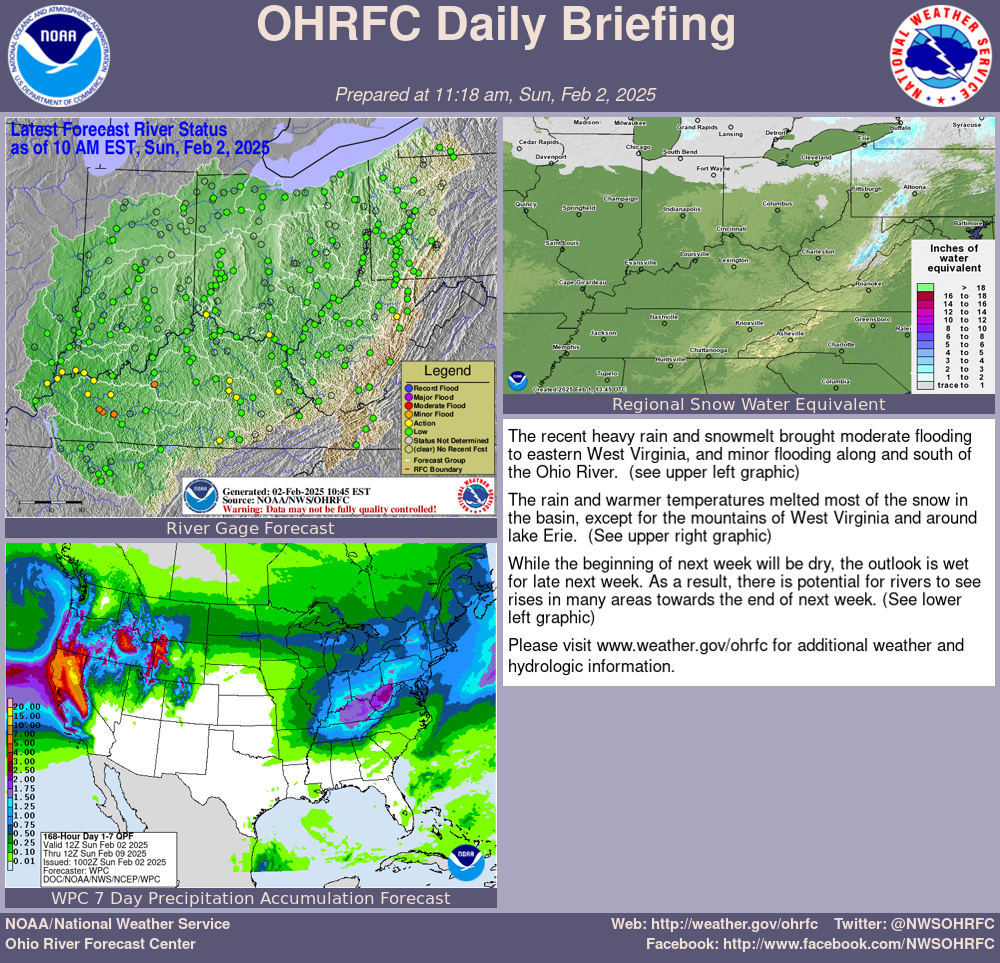
The rain has ended but the flooding will continue. At my Cheviot 3W site I had a 3 day storm total of 4.16 inches of rain with a February total to date now at 8.24 inches. A winter which had been running a bit below normal in precipitation is now well above normal.
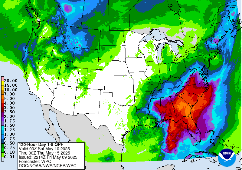
Expect a period of strong wind Sunday morning in Cincinnati, followed by a couple days of cooler and dryer weather. Another less robust weather system will bring more rain later this week. Here is the Wednesday-Friday rainfall outlook:

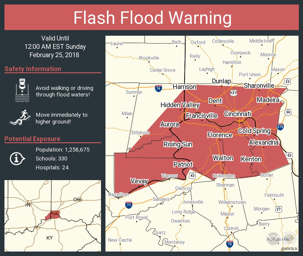
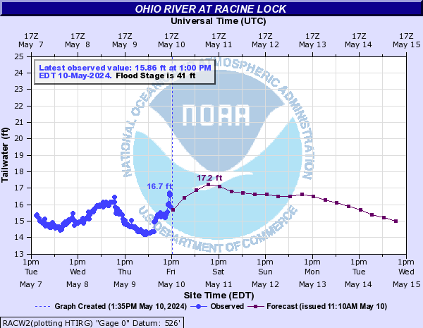
The Flood Warning continues for the Ohio River at Cincinnati until further notice. At 6 AM the stage was 59.8 feet. Flood stage is 52 feet. Moderate flooding is occurring and is forecast to continue. The river will rise to near 60.6 feet by this afternoon. The river will then begin falling, but remain above flood stage for the next 5 days. At stages near 61 feet, flooding worsens in the East End, as well as along the riverfront. Pete Rose Way becomes flooded and Kellogg Road flooding worsens. Homes and businesses in the East End and California are significantly flooded. Much of Route 52 continues to flood between Cincinnati and New Richmond. Backwater flooding up the Little Miami River affects Anderson Township up to Newtown. Low-lying roads in Newport, Ludlow and Bromley, Kentucky flood, as well as portions of Lawrenceburg and Aurora, Indiana.
...A PERIOD OF STRONG WINDS EXPECTED THIS MORNING...

Winds will turn to the west and will gust to around 40 mph later
this morning with the passage of a cold front.

Unsecured outdoor items may be blown around. High profile
vehicles should use caution.

$$
Flood Warning
Flood Statement
National Weather Service Wilmington OH
653 AM EST Sun Feb 25 2018

...The Flood Warning continues for the following rivers...
  Ohio River at Cincinnati

INC029-115-KYC015-037-117-OHC025-061-251953-
/O.CON.KILN.FL.W.0012.000000T0000Z-000000T0000Z/
/CCNO1.2.ER.180218T2154Z.180225T1800Z.000000T0000Z.NO/
653 AM EST Sun Feb 25 2018

The Flood Warning continues for
  The Ohio River at Cincinnati
* until further notice.
* At 6 AM the stage was 59.8 feet.
* Flood stage is 52 feet.
* Moderate flooding is occurring and is forecast to continue.
* The river will rise to near 60.6 feet by this afternoon. The river will
  then begin falling, but remain above flood stage for the next 5 days.
* At stages near 61 feet, flooding worsens in the East End, as well as
  along the riverfront.  Pete Rose Way becomes flooded and Kellogg Road
  flooding worsens.  Homes and businesses in the East End and California
  are significantly flooded.  Much of Route 52 continues to flood
  between Cincinnati and New Richmond.  Backwater flooding up the Little
  Miami River affects Anderson Township up to Newtown.  Low-lying roads
  in Newport, Ludlow and Bromley, Kentucky flood, as well as portions of
  Lawrenceburg and Aurora, Indiana.


&&

LAT...LON 3890 8418 3885 8429 3903 8449 3903 8494
      3916 8490 3914 8437

$$
Flood Warning
Flood Warning
National Weather Service Wilmington OH
636 AM EST SUN FEB 25 2018

OHC017-061-252330-
/O.NEW.KILN.FA.W.0006.180225T1136Z-180225T2330Z/
/00000.0.ER.000000T0000Z.000000T0000Z.000000T0000Z.OO/
Hamilton OH-Butler OH-
636 AM EST SUN FEB 25 2018

The National Weather Service in Wilmington has issued a

* Flood Warning for Mill Creek in...
  North central Hamilton County in southwestern Ohio...
  Southeastern Butler County in southwestern Ohio...

* Until 630 PM EST Sunday.

* At 635 AM EST, the river gage near Glendale Milford indicated that
  flooding was occurring along Mill Creek.

* Flooding will occur near the Sharon and Mosteller Road
  intersection, as well as along Canal Road. Flood waters will begin
  to enter some businesses near the creek in Reading, Evendale and
  Sharonville.

PRECAUTIONARY/PREPAREDNESS ACTIONS...

Do not drive your vehicle into areas where water covers the roadway.
The water depth may be too great to allow your vehicle to cross
safely and the road beneath may not be intact.

&&

LAT...LON 3934 8446 3934 8437 3929 8437 3922 8443
      3922 8446

$$

Sites
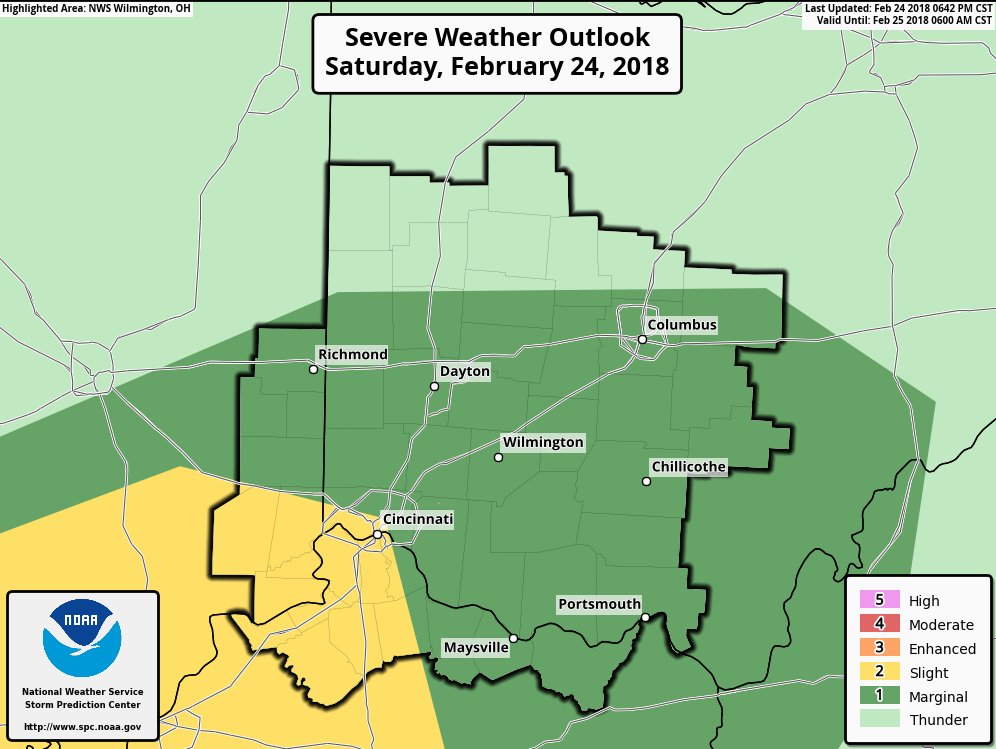
Hazardous Weather Outlook
National Weather Service Wilmington OH
619 AM EST Sun Feb 25 2018

INZ066-073>075-080-KYZ089>100-OHZ070>074-077>082-088-261130-
Franklin IN-Ripley-Dearborn-Ohio-Switzerland-Carroll-Gallatin-Boone-
Kenton-Campbell-Owen-Grant-Pendleton-Bracken-Robertson-Mason-Lewis-
Butler-Warren-Clinton-Ross-Hocking-Hamilton-Clermont-Brown-Highland-
Adams-Pike-Scioto-
619 AM EST Sun Feb 25 2018

This Hazardous Weather Outlook is for Southeast Indiana, Northeast
Kentucky, Northern Kentucky, Central Ohio, South Central Ohio and
Southwest Ohio.

.DAY ONE...Today and Tonight.

Strong gusty winds behind a cold frontal passage will gust to around
40 mph this morning.

River flooding will persist. Please check our web site at
www.weather.gov/iln for more information on the river flooding.

.DAYS TWO THROUGH SEVEN...Monday through Saturday.

River flooding will persist. Please check our web site at
www.weather.gov/iln for more information on the river flooding.

.SPOTTER INFORMATION STATEMENT...

Spotter activation is not expected at this time.

$$
Flood Advisory
Flood Advisory
National Weather Service Wilmington OH
415 AM EST SUN FEB 25 2018

INC029-115-137-155-KYC015-037-077-117-OHC061-251515-
/O.NEW.KILN.FA.Y.0018.180225T0915Z-180225T1515Z/
/00000.N.ER.000000T0000Z.000000T0000Z.000000T0000Z.OO/
Ohio IN-Ripley IN-Dearborn IN-Switzerland IN-Kenton KY-Campbell KY-
Boone KY-Gallatin KY-Hamilton OH-
415 AM EST SUN FEB 25 2018

The National Weather Service in Wilmington has issued a

* Flood Advisory for...
  Ohio County in southeastern Indiana...
  Ripley County in southeastern Indiana...
  Dearborn County in southeastern Indiana...
  Switzerland County in southeastern Indiana...
  Kenton County in northern Kentucky...
  Campbell County in northern Kentucky...
  Boone County in northern Kentucky...
  Gallatin County in northern Kentucky...
  Hamilton County in southwestern Ohio...

* Until 1015 AM EST.

* At 415 AM EST, minor flooding was reported across the region with
  several roads closed due to high water.

* Minor flooding of low-lying and poorly drained streets, highways
  and underpasses will continue as the water gradually recedes this
  morning. In addition, farmland near creeks, streams and drainage
  ditches will continue to experience minor flooding.

Some locations that will experience minor flooding include...
Cincinnati, Covington, Florence, Independence, Norwood, Forest Park,
Erlanger, Fort Thomas, Newport, Sharonville, Blue Ash, Loveland,
Springdale, Reading, Montgomery, Harrison, North College Hill,
Madeira, Edgewood and Alexandria.

PRECAUTIONARY/PREPAREDNESS ACTIONS...

Turn around, don`t drown when encountering flooded roads. Most flood
deaths occur in vehicles.

To report flooding, go to our website at weather.gov/iln and submit
your report via social media, when you can do so safely.

&&

LAT...LON 3920 8544 3931 8522 3928 8426 3922 8432
      3920 8428 3902 8432 3887 8425 3881 8442
      3879 8453 3880 8463 3878 8466 3884 8479
      3878 8482 3880 8489 3875 8502 3876 8504
      3869 8516 3870 8520 3891 8520 3892 8545

$$

Franks
Flood Warning
Flood Statement
National Weather Service Wilmington OH
235 AM EST Sun Feb 25 2018

...The Flood Warning continues for the following rivers...

  Little Miami River at Kings Mills
  Little Miami River at Milford
  Great Miami River near Middletown
  Great Miami River at Miamitown
  Scioto River at Piketon

...The Flood Warning continues for the following rivers...
  Great Miami River at Sidney
  Scioto River at Circleville
  Big Darby Creek at Darbyville

OHC025-061-165-251535-
/O.EXT.KILN.FL.W.0020.180225T0732Z-180225T2337Z/
/KIMO1.1.ER.180225T0504Z.180225T1200Z.180225T1737Z.NO/
235 AM EST Sun Feb 25 2018

...Flooding now expected to continue until this evening...
The Flood Warning continues for
  The Little Miami River at Kings Mills
* until this evening.
* At 10 PM the stage was 16.3 feet.
* Flood stage is 17 feet.
* Minor flooding is forecast.
* The river will rise above flood stage early this morning and
  continue to rise to near 20.0 feet later this morning. The river will fall
  below flood stage this afternoon.
* At stages near 19.5 feet, flooding can be expected near Turtle Creek
  in South Lebanon.  Roads affected by the flooding include Broadway,
  McKinley and Pike Streets.


&&

LAT...LON 3941 8409 3936 8408 3933 8421 3927 8425
      3929 8428 3937 8426

$$
Flood Warning
Flood Statement
National Weather Service Wilmington OH
235 AM EST Sun Feb 25 2018

...The Flood Warning continues for the following rivers...

  Little Miami River at Kings Mills
  Little Miami River at Milford
  Great Miami River near Middletown
  Great Miami River at Miamitown
  Scioto River at Piketon

...The Flood Warning continues for the following rivers...
  Great Miami River at Sidney
  Scioto River at Circleville
  Big Darby Creek at Darbyville

OHC025-061-251535-
/O.EXT.KILN.FL.W.0021.180225T0732Z-180226T0505Z/
/MLGO1.1.ER.180225T0425Z.180225T1200Z.180225T2305Z.NO/
235 AM EST Sun Feb 25 2018

...Flooding now expected to continue until late tonight...
The Flood Warning continues for
  The Little Miami River at Milford
* until late tonight.
* At 1 AM the stage was 19.4 feet.
* Flood stage is 17 feet.
* Minor flooding is occurring and minor flooding is forecast.
* The river will continue rising to near 21.0 feet by this morning. The
  river will fall below flood stage this evening.
* At stages near 21.0 feet, flooding can be expected in low areas
  between Main Street and the river in Milford.  Lowland flooding occurs
  along the river in Clermont and Hamilton Counties.


&&

LAT...LON 3929 8428 3929 8426 3927 8425 3916 8428
      3907 8443 3910 8443

$$
Flood Warning
Flood Statement
National Weather Service Wilmington OH
235 AM EST Sun Feb 25 2018

...The Flood Warning continues for the following rivers...

  Little Miami River at Kings Mills
  Little Miami River at Milford
  Great Miami River near Middletown
  Great Miami River at Miamitown
  Scioto River at Piketon

...The Flood Warning continues for the following rivers...
  Great Miami River at Sidney
  Scioto River at Circleville
  Big Darby Creek at Darbyville

OHC061-251534-
/O.EXT.KILN.FL.W.0017.000000T0000Z-180228T0048Z/
/MIAO1.1.ER.180225T0057Z.180225T1800Z.180227T1848Z.NO/
235 AM EST Sun Feb 25 2018

The Flood Warning continues for
  The Great Miami River at Miamitown
* until Tuesday evening.
* At 1 AM the stage was 19.6 feet.
* Flood stage is 16 feet.
* Minor flooding is occurring and minor flooding is forecast.
* The river will continue rising to near 23.7 feet by this afternoon.
  The river will fall below flood stage early Tuesday afternoon.
* At stages near 24.0 feet, moderate flooding occurs along the Great
  Miami River south of Miamitown over southwest Miami Township.
  Flooding also occurs along the river from New Baltimore to Cleves.


&&

LAT...LON 3930 8467 3931 8463 3931 8460 3920 8469
      3911 8482 3915 8482

$$
Flood Advisory
Flood Advisory
National Weather Service Wilmington OH
1259 AM EST Sun Feb 25 2018

...The National Weather Service in Wilmington has issued a Flood
Advisory for the following locations...

  Whitewater River at Brookville


INC029-047-OHC061-251359-
/O.NEW.KILN.FL.Y.0003.180225T0559Z-180226T1759Z/
/BRKI3.N.ER.000000T0000Z.000000T0000Z.000000T0000Z.OO/
1259 AM EST Sun Feb 25 2018

The National Weather Service in Wilmington has issued a
* Flood Advisory for
  The Whitewater River at Brookville,
* until Monday afternoon.
* At 11 PM the stage was 12.8 feet.
* Flood stage is 20 feet.
* The river will continue rising to near 15.0 feet after midnight this
  morning then begin falling.
* At stages near 15.0 feet, The river overflows into some yards, as well
  as campgrounds near Cedar Grove and New Trenton, with lowland flooding
  also occurring in West Harrison, Indiana and Harrison, Ohio,
  especially near the Lawrenceburg Road area.


