This Hazardous Weather Outlook is for Southeast Indiana, Northern
Kentucky, South Central Ohio and Southwest Ohio.
.DAY ONE…Today and Tonight.
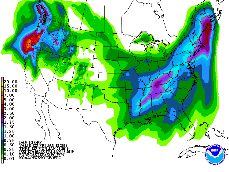
Rain will develop late tonight. This rain may begin as a wintery
mix at some locations at the onset prior to changing to all rain.
.DAYS TWO THROUGH SEVEN…Saturday through Thursday.
Rain will develop early Saturday. This rain may begin as a wintery
mix at some locations at the onset prior to changing to all rain
across the region Saturday morning. Rainfall may cause localized
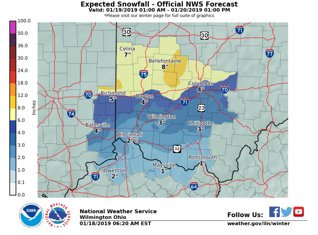
flooding to occur. The rain will change back to snow by Saturday
evening with some accumulations likely. Wind chills may fall to
around 10 below zero Sunday night.
346 AM EST Fri Jan 18 2019
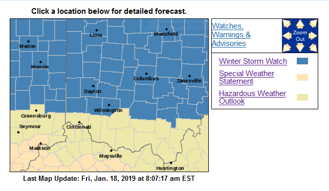
…WINTER STORM WATCH REMAINS IN EFFECT FROM LATE TONIGHT THROUGH LATE SATURDAY NIGHT…
* WHAT…Heavy mixed precipitation possible. Total snow
accumulations of 4 to 7 inches and ice accumulations of around
one tenth of an inch possible. Winds could gust as high as 40
mph Saturday night.
* WHERE…Portions of East Central and Southeast Indiana and
Central, Southwest and West Central Ohio.
Wayne-Fayette IN-Union IN-Franklin IN-Darke-Union OH-Delaware-
Miami-Champaign-Clark-Madison-Franklin OH-Licking-Preble-
Montgomery-Greene-Fayette OH-Butler-Warren-Clinton-
Including the cities of Richmond, Connersville, Liberty,
West College Corner, Brookville, Greenville, Marysville,
Delaware, Troy, Piqua, Tipp City, Urbana, Springfield, London,
West Jefferson, Plain City, Columbus, Newark, Eaton, Camden,
Dayton, Kettering, Beavercreek, Fairborn, Xenia,
Washington Court House, Hamilton, Middletown, Fairfield, Oxford,
Mason, Lebanon, Springboro, Wilmington, and Blanchester
* WHEN…From late tonight through late Saturday night.
* ADDITIONAL DETAILS…Travel could be very difficult.
PRECAUTIONARY/PREPAREDNESS ACTIONS…
A Winter Storm Watch means there is potential for significant
snow, sleet or ice accumulations that may impact travel. Continue
to monitor the latest forecasts.